Today started off much nicer than I thought it would! This morning we had abundant sunshine as the sun came up over the horizon. A weak inverted ridge of high pressure built over New England this morning and that allowed the low overcast to dry out.
Unfortunately the bright sunshine isn’t going to be a permanent fixture today as the atmosphere remains unstable thanks to a pool of cold air sitting over us. As the sun comes up the atmosphere will destabilize and clouds will form. Still, we should have a mix of sun and clouds which is better weather than we’ve had. It’s also possible that a shower or two will develop but I’ve left that out of the forecast this morning hoping that the relatively dry air mass will suppress any shower development.
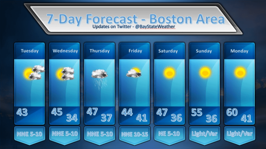
Looking at Wednesday, that should be a dry and partly cloudy day for the most part. A storm system will be sliding south of us through the day on Wednesday but, initially, this storm will be too far to the south to throw any rainfall our way. By Wednesday evening, however, this storm will stall out over the ocean and then perform a loop around. While this loop is happening it looks like we’re going to have some rainfall thrown our way. It appears Thursday will be fairly gloomy once again with rain, drizzle and fog as the ocean storm continues to throw moisture back at us from the east.
This storm will shove off by Friday and, going into the weekend it looks like our weather will get better and better each day. By next Monday I’m looking at the possibility of 60 or better! That should make everyone feel a little more optimistic. ![]()
