Issued April 2 2020 – 10:30am
Good morning!
This is primarily an update to yesterday’s forecast so I am going to keep the discussion brief. The forecast is working out more or less as expected.
The storm that slid by to the south yesterday blew up into a monster out at sea overnight.

If you look carefully at the storm you can make out an eye like feature at its center. This is normally seen with hurricanes but it can also manifest in fairly intense mid-latitude cyclones. Observations indicate that this system has a central pressure below 980 mb. By comparison, Superstorm Sandy had a central pressure of 945.5 mb over Atlantic City when it made landfall back in 2012. So while this storm is a bit weaker it still packs quite a punch.
This system will impact New England but not in the same way that Sandy tore into the Mid-Atlantic coast 8 years ago. This storm will generate some pretty rough weather conditions along the coast tonight and on Friday. The low pressure area is currently performing a loop and is, at this moment, moving in a westerly direction. This is called retrograde motion. The storm will continue to retrograde back toward the New England coast through Friday morning. As it does so it will wrap some fairly hefty rainfall and wind back toward New England.
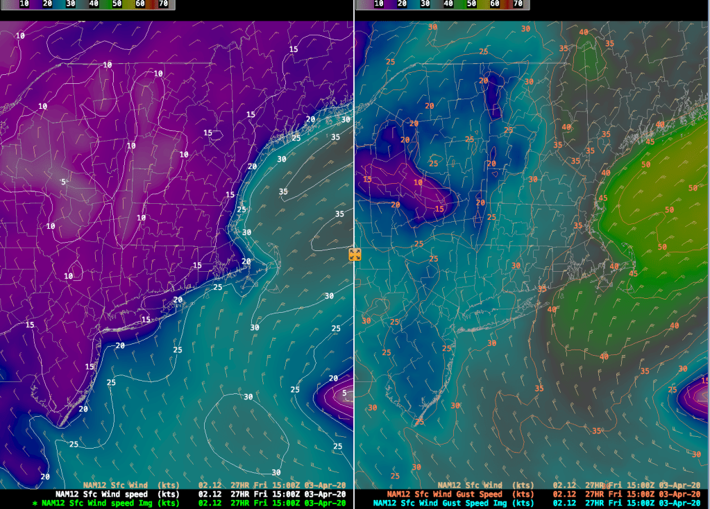
The image above is the wind speed and direction and wind gust speed forecast from the 12km North American Model (NAM-12). This forecast is for 11am Friday. As you can see, sustained winds (on the left) in Boston are going to be from the NE at 15-25 kt (1 kt = 1.15 mph in case you want to convert). Out on Cape Cod, however, you will be contending with 20-35 kt sustained winds out of the NE. What’s worse are the wind gusts. In the Boston area we are looking at 35-40 kt gusts and out on the Cape and Islands 40-50 kt gusts are not out of the question. One way or the other, if you are planning to venture out tomorrow for any reason, it’s not going to be pleasant, especially in the morning hours when the storm is making its closest pass.
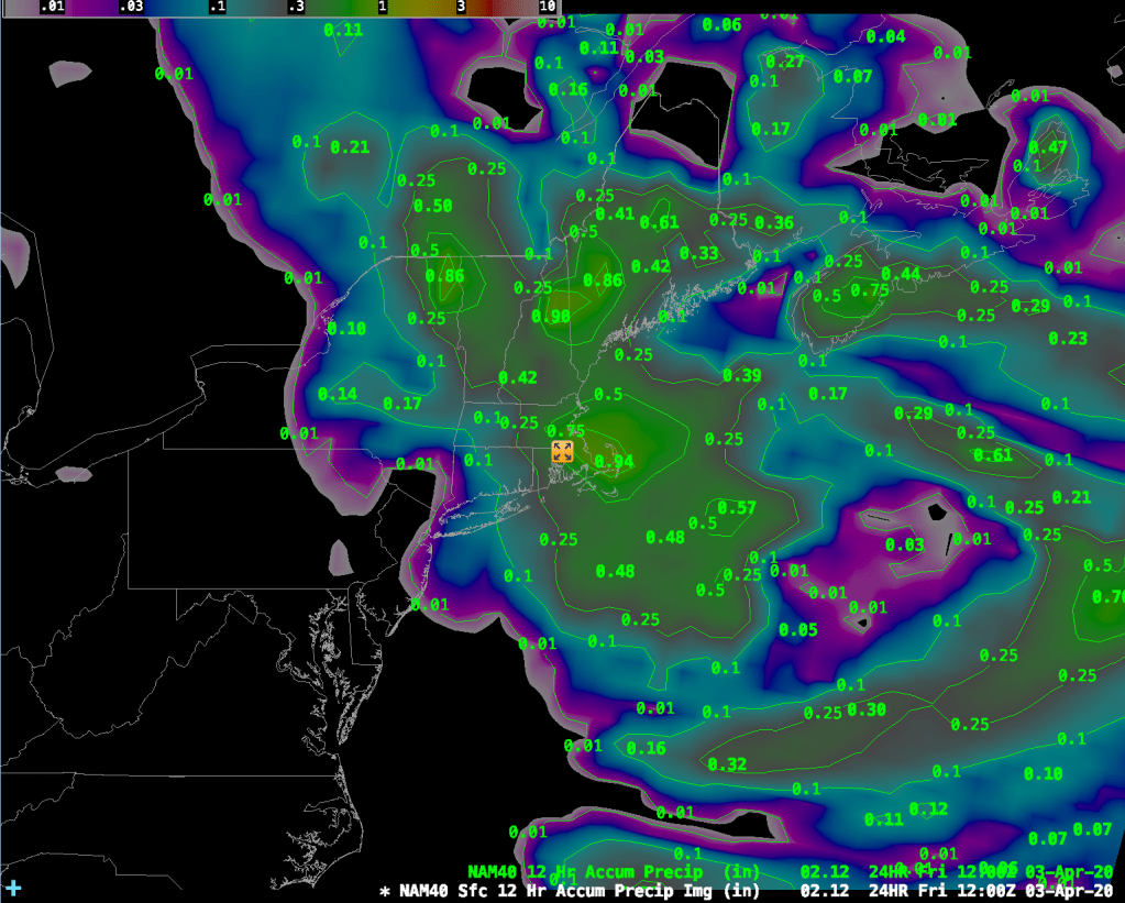
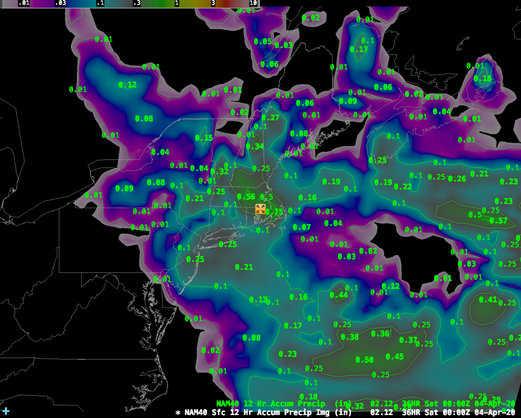
In addition to the wind, we are also going to get quite a bit of rainfall during the next 48 hours or so. The images above show the 12 hour rainfall amounts from the 40km NAM (NAM-40). The image on the left runs from 8pm tonight through 8am tomorrow morning and the image to the right shows total precipitation from 8am Friday – 8:00pm Friday. The totals over Boston add up to about 1.20″ of rainfall from 8pm tonight through 8pm Friday night. The GFS model shows about 1.30″ for the same time period so, all in all, we are looking at a pretty good soaking from this system on top of the wind. Great day to say socially distanced and indoors.
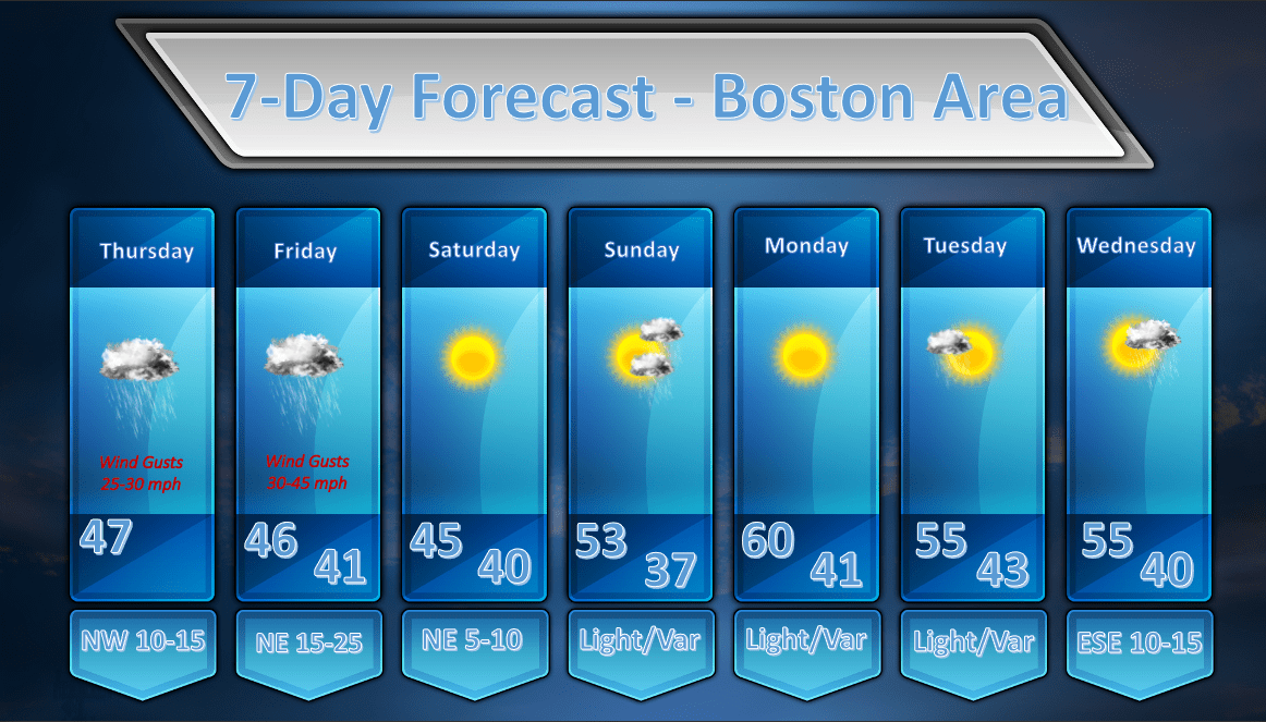
As for the remainder of the forecast:
Once the storm gets out of here on Saturday the sun should return and it looks like we will see a gradual warming trend into next week. Sunday may feature a shower or two as a weak front slides by but I’m not totally sure we’ll even see rain at all from that system. Tuesday may bring along a morning shower and we may see late day showers on Wednesday, but again, these are iffy chances of precipitation at this point.
That’s all for today!
