Issued April 9 2020 – 6:00 pm
FORECAST DISCUSSION:
REMAINDER OF THURSDAY: The forecast is working out quite well today. While there doesn’t appear to have been any thunderstorm activity north of the MA pike and east of I-91, a few thunderstorms did move through far western MA earlier today and several thunderstorms, some requiring severe thunderstorm warnings, did move through Long Island sound, coastal CT, coastal RI and south coastal MA. These storms more or less developed right in the area of most instability right on schedule. The last of the severe thunderstorm warnings will expire out on Cape Cod @ 5:30pm.
Strong and gusty winds, associated with the frontal passage, are on the way into our area. Wind gusts of 25-35 mph are showing up in eastern NY, western MA and CT. These wind gusts will progress to the east along with the clearing. It should be a rather breezy and gusty night tonight as the front pulls away. Gusts upward of 25-35 mph will be possible in metro Boston and possibly upwards of 35-45 mph on the Cape and Islands.
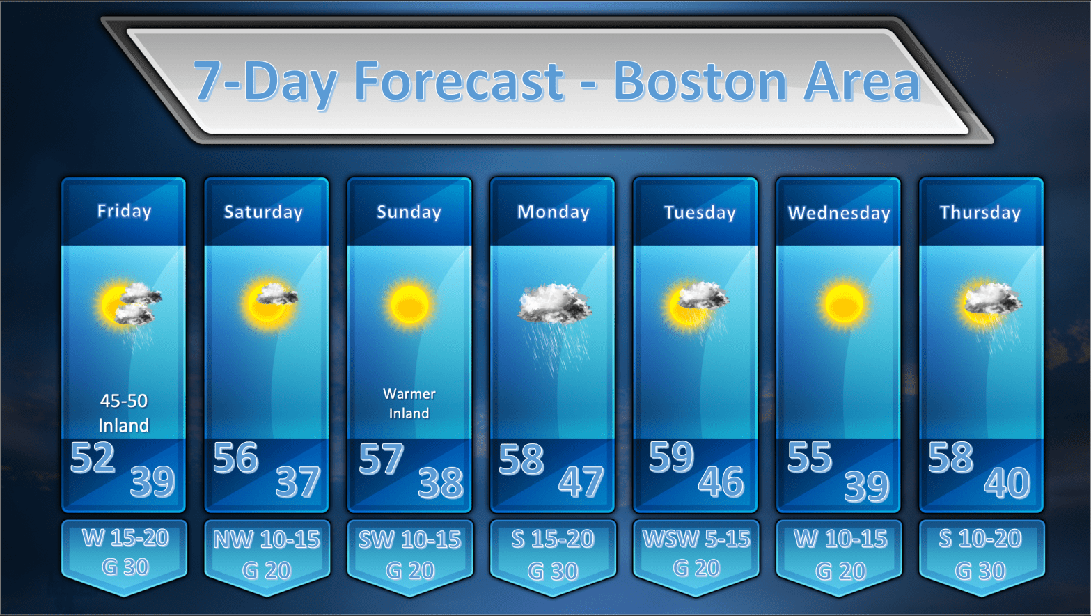
FRIDAY: Not much change to the Friday forecast. Yesterday’s discussion follows:
The front/storm that passes through Thursday will blow up in to a pretty good sized storm to our northeast. This should allow the pressure gradient to remain pretty tight which should lead to another breezy and gusty day on Friday with westerly winds 15-25 mph sustained along with gusts up to 35 mph strongest along with south coast, Cape and Islands. It will be unsettled as an upper low remains close to New England. Clouds and the risk of a shower will be around for the balance of the day. I think it will be a bit on the cool side as well, and I am going to undercut guidance by a bit on Friday. I’m going to go with highs predominantly in the lower 50’s for much of the area.
SATURDAY: Saturday looks less unsettled to me. It looks like the upper low is going to lift out fairly quickly and the mid levels of the atmosphere are going to dry out fairly well. I am removing any mention of shower activity from Saturday’s forecast. If any showers are going to develop they would be over northern New England. Expect a mostly sunny day with a few afternoon fair weather clouds.
SUNDAY: Sunday looks like a nice days with a mid level high pressure ridge building over the top of us. The models are indicating quite a bit of moisture streaking in at mid-levels so I’m not entirely convinced that it’s going to be a perfectly clear day like the models are suggesting but that’s what I’m going with for now. It should be pretty mild as well with temperatures at the coast in the mid-upper 50’s. Inland, temperatures should reach the low to mid 60’s. Winds will be fresh out of the SW with occasional gusts.
MONDAY: The models continue to advertise a fairly vigorous low pressure area rolling up into the Great Lakes on Monday and this should still lead to a burst of rainfall moving up into New England. The models have become less aggressive about developing a secondary coastal low pressure area and this has had the effect of focusing the heavier rainfall back toward the western part of New England. PWAT values are still above 1.00″ so there is plenty of moisture to wring out of the atmosphere. Eastern portions of MA/RI/CT could get 0.50″ – 1.00″ of rain while western New England could see in excess of 1.00″. There is decent agreement between the ECMWF and GFS on this idea so I am going to buy into it. I expect this is going to shift around a little more before we get to Monday.
TUESDAY: No change to the previous forecast here. Monday’s storm rolls up into James Bay and drier air briefly works into New England allowing for morning and early afternoon sunshine. It appears that a surface trough of low pressure is going to be rotating around the storm and it looks like this is going to provide the focus for some clouds and perhaps a few showers late on Tuesday.
WEDNESDAY: Nothing remarkable about Wednesday’s weather. High pressure building in from the west will clear us out and it should be a rather pleasant day with a mix of sun and clouds with highs in the mid 50’s.
THURSDAY: A weak trough of low pressure looks like it may generate a few showers over the western part of MA/SE VT/West NH/NW CT during the late morning. Otherwise nothing very interesting happening on Thursday the 16th.
