Issued April 10 2020 – 8:00 PM
FORECAST DISCUSSION:
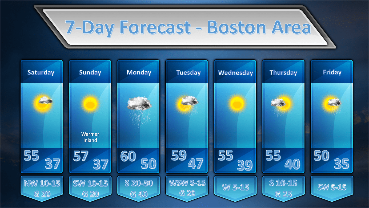
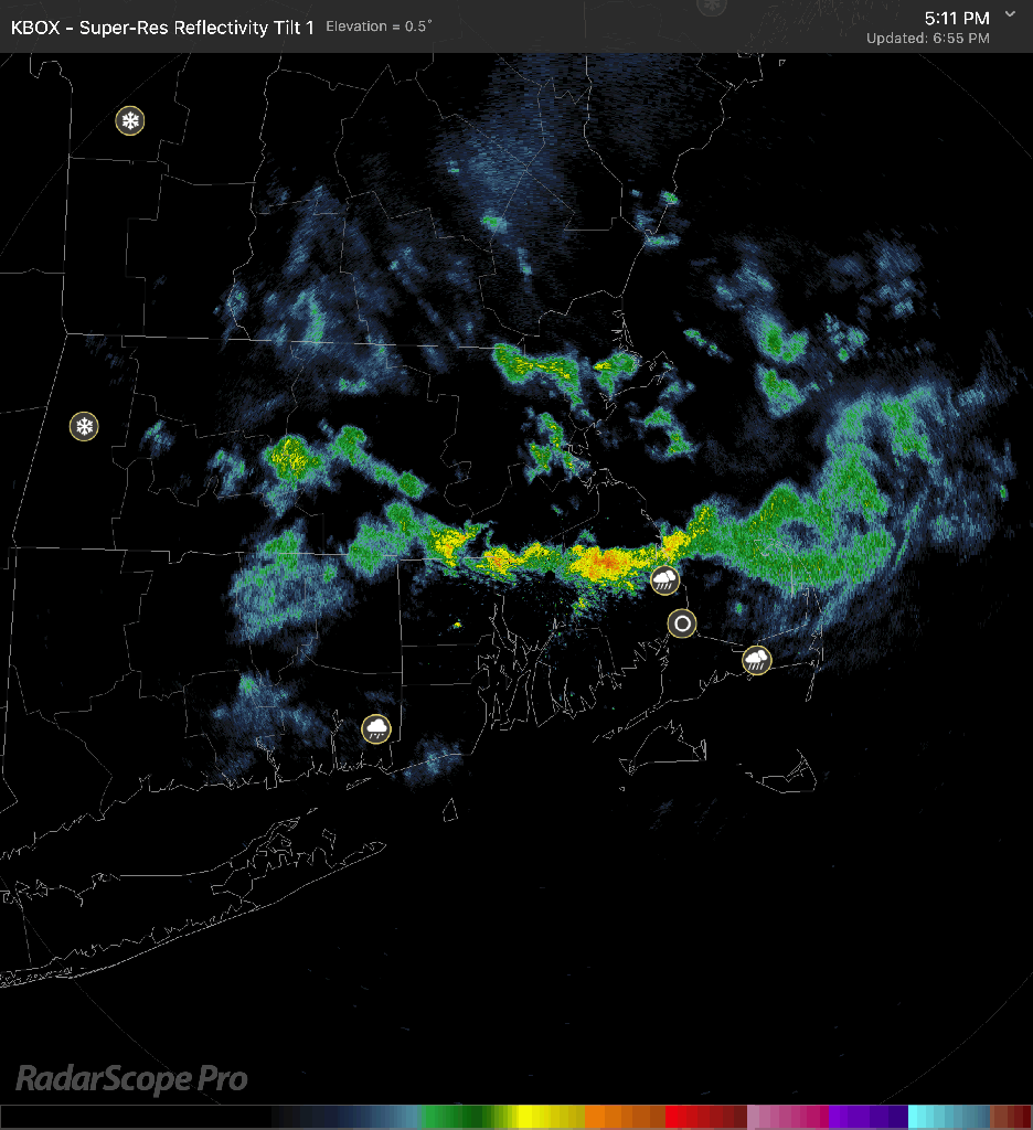
REMAINDER OF FRIDAY: So the weather worked out pretty much as expected today with a sunny start then clouds and showers. In fact as of this writing showers are still pinwheeling through SNE and will continue to do so for another hour or perhaps two. These showers are forming in response to a large upper level low over our area right now. Spokes of upper level energy rotating around the low tend to spark a shower or two here and there. A line of showers that moved from southern NH through MA and exited just south of Cape Cod had the most potent of the showers. There was even a little frozen precipitation (graupel) mixed in with the strongest of these showers.
All this activity will come to an end as the atmosphere stabilizes as the sun goes down and the upper level low pulls away to our north.
SATURDAY: The upper low is going to lift out fairly quickly and the mid levels of the atmosphere are going to dry out fairly well. There should be much more sunshine tomorrow with some fair weather clouds forming in the afternoon. Since there will be less mid level moisture available I don’t think we will see much in the way of shower activity if anything at all. At this point, I am still leaving showers out of tomorrow’s forecast.
SUNDAY: Sunday looks like a nice day with a mid level high pressure ridge building over the top of us through the morning hours. The models are indicating quite a bit of moisture streaking in at mid-levels so some cloudiness is likely to develop on Sunday. I think they will hold off until early afternoon as we remain east of the 700 mb ridge axis until about then. Once the ridge axis slides by I think middle clouds will build throughout New England say around 1-2pm as the warm advection associated with an approaching warm front starts being felt at that level of the atmosphere. Lower cloudiness will work in later in the afternoon as the warm frontal boundary advances. I don’t see much in the way rainfall on Sunday however. I expect we will stay dry.
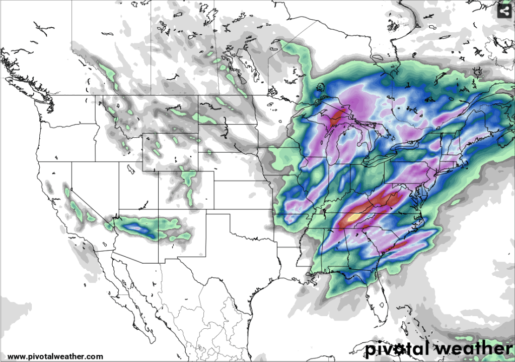
GFS 24 h Precipitation Forecast 8pm Sunday – 8pm Monday 
ECMWF 24 h Precipitation Forecast 8pm Sunday – 8pm Monday
MONDAY: Low pressure which will cause a fairly significant severe weather outbreak down in the south on Sunday will then move toward our area on Monday with the promise of some heavy rainfall. Precipitable water values as high as 1.4″ will transit across New England on Monday along with a strongly diffluent 500 mb flow. This should allow for periods of heavy precipitation throughout New England. Rainfall amounts of .80 – 1.20″ will be possible generally across southern New England but I wouldn’t be surprised to see locally higher amounts in heavier downpours. The model output above shows the GFS and Euro 24h total precipitation amounts. The two models are in fairly good agreement so it looks pretty certain that we will see a pretty good rain event. There is also some indication of elevated instability associated with this system which could spawn the chance of a few rumbles of thunder but that appears to me to be a low risk situation at this time.
TUESDAY: Monday’s storm rolls up into James Bay and drier air works into New England allowing for fairly abundant sunshine for most of the day. It had looked like there might be a chance of showers on Tuesday but that risk seems to have fallen to the wayside.
WEDNESDAY: Nothing remarkable about Wednesday’s weather. Weak low pressure will be tracking far to our south but it may throw some clouds into southern RI, CT and the Cape. For the rest of us there will be abundant sunshine and seasonable temperatures.
THURSDAY: A weak area of low pressure looks like it may generate clouds and a few showers during Thursday. A few hundredths of an inch of precipitation may be possible with this system as it passes through.
FRIDAY: On balance friday should be an ok day for much of New England but a weak upper level disturbance riding along in the flow may generate some showery rainfall, especially late in the day to the south of Boston. A couple of tenths of an inch may possible in E CT, RI and SE MA late in the day.
