Issued: April 13, 2020 at 9:00pm
FORECAST DISCUSSION:
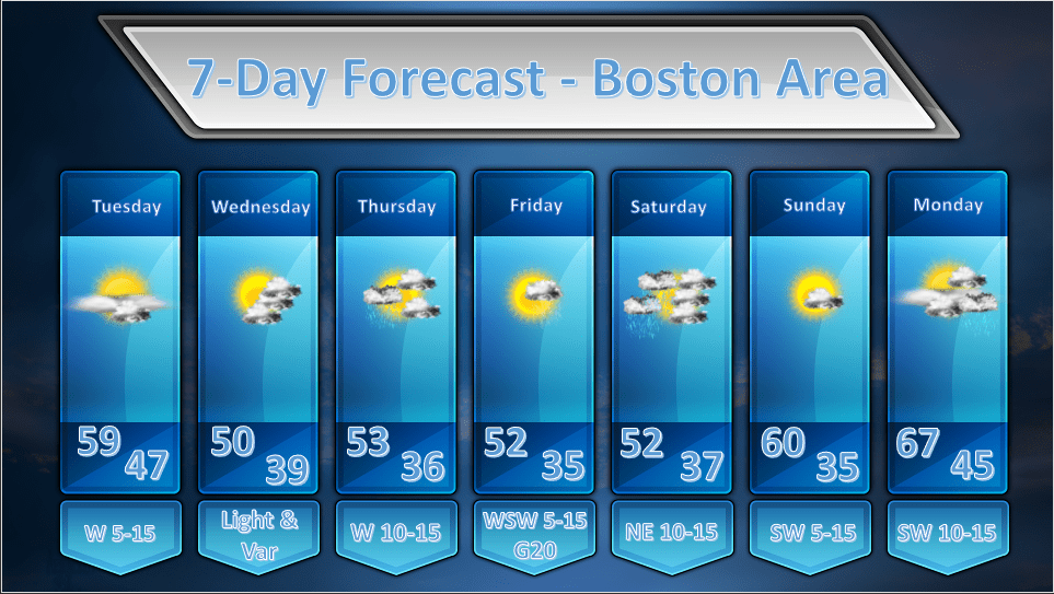
TUESDAY: We should start of mostly sunny on Tuesday as a surface high pressure ridge builds in from the west. Some mid/high level moisture will transit across New England and may generate some wispy high clouds or some middle level clouds. I am not generally expecting overcast conditions however. Partly sunny skies should prevail in the afternoon. It looks like a rather mild day as well with high temperatures around 60 degrees.
WEDNESDAY: A very weak wave of low pressure will track south of us on Wednesday and this should yield partly cloudy skies for the morning hours. As the low pressure wave pulls away some drier air will work in a mid levels and that should largely evaporate any cloud cover for the afternoon. As a weak surface trough of low pressure approaches from the west we could see a little more cloud cover develop toward sunset but it should, generally remain dry.
THURSDAY: During the early morning hours of Thursday an upper level disturbance will be transiting across the area and this may generate a shower or two in the morning. This will be a quick moving event and we should remain largely dry and the sun should break out for a bit during the late morning. Unsettled weather will move in for the second half of Thursday as we remain under the influence of a weak upper level trough. No rain should fall but there will be in and out sunshine especially in the areas where the sun is able to break through and warm the atmosphere which will cause the development of fair weather cumulus clouds.
FRIDAY: Friday should start off as a fairly nice day with mostly sunny skies. There will be a wave of low pressure approaching the region by afternoon and this will throw a shield of cloudiness over the top of us. It does not appear, however, that this low pressure wave will be close enough to throw any rainy weather our way until well after dark on Friday.
SATURDAY: As the wave of low pressure that passed south of New England during Friday night exits we may have some showers still hanging out on Saturday morning. It looks like clouds will hang back after rainfall exits but we could see a few breaks of sun before the sun sets.
SUNDAY: Looks like a nice day with no weather systems immediately threatening the area. It should be mostly sunny and mild.
MONDAY: A cold frontal boundary will be approaching from the north and a brisk southwesterly flow will push some clouds and rather warm air into New England. It will be mostly cloud but temperatures will be in the mid to upper 60’s for much of the region. There may be a late day shower or two as the front slides through.
