Issued: April 15, 2020 at 11:00am
FORECAST DISCUSSION:
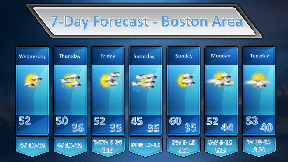
WEDNESDAY: A weak wave of low pressure is sliding south of New England this morning. Along with this low are variable amounts of cloudiness from the South Shore northwestward, and overcast skies to the southeast with some light rain out over Cape Cod. As all of this is pulling away drier air will continue to advect in from the west and should tend to clear us out and dry out the air so no further rainfall should be coming down anywhere in New England by the afternoon. High temperatures today will be on the cool side but more or less seasonable for mid-April. Expect highs 50-55 throughout much of MA. In far NW MA temperatures will be a shade cooler in the 45-50 degree range.
THURSDAY: During the early morning hours of Thursday an upper level disturbance will be transiting across the area and this may generate a shower or two in the morning. This will be a quick moving event and we should remain largely dry and the sun should break out for a bit during the late morning. Unsettled weather will move in for the second half of Thursday as we remain under the influence of a weak upper level trough. No rain should fall but there will be in and out sunshine especially in the areas where the sun is able to break through and warm the atmosphere which will cause the development of fair weather cumulus clouds.
FRIDAY: Friday should start off as a fairly nice day with mostly sunny skies. There will be a wave of low pressure approaching the region by afternoon and ascent caused by weak overrunning will throw a shield of cloudiness over the top of us by afternoon. As the day wears on showers and light rain with some snowflakes mixing in should start moving in after the dinner hour and the evening and overnight hours of Friday look miserable and cold.
SATURDAY: Saturday looks to start off wet and possibly a little white north and west of the city as the low pressure area exits the region. Fortunately by afternoon any rain or snow falling across the region should largely be over. The Cape and Islands may still be catching some drizzle and fog by Saturday afternoon. By evening, everyone is out of the precipitation shield. As it dries out it will also get a bit chilly overnight on Saturday.
SUNDAY: Looks like a nice day with no weather systems immediately threatening the area. It should be mostly sunny and mild. By later in the day on Sunday clouds will advance from the north so as the sun is going down, skies will be probably be mostly overcast at that hour.
MONDAY: Monday’s forecast has changed a bit as it appears the colder air banked off to our north is going to win out by dropping a back door cold front through the region on Monday morning. It looks like cloudy and cool conditions will prevail as E-SE winds blow in off of the cold Atlantic Ocean holding temperatures in the 50’s.
TUESDAY: The cold fronts and low pressure areas finally exit the area on Tuesday and we are just left with a kind of cool NW flow and clear skies. Once again high temperatures will be a wee bit below normal for this time of year, in the low to middle 50’s.
