WEATHER SUMMARY:
…ONE DOWN, 2 TO GO. A STORMY PERIOD AHEAD…
The first of 3 storms that will impact us this week is moving out to sea tonight and a bubble of high pressure is coming along to take it’s place. This should allow us to have a fairly nice day on Saturday.
Light winds and left over low level moisture over interior New England has led to the development of some fog in spots in CT and western MA. These patchy areas of light fog will burn off quickly in the morning as the temperatures rise.
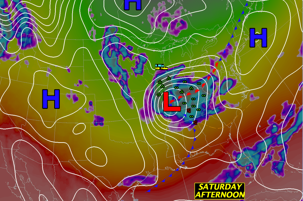
As high pressure traverses the area to our south we should see mostly sunny skies through most of the daylight hours tomorrow. But some high clouds will advance into the area toward sunset and that will be the harbinger of deteriorating weather conditions for Sunday.
Winds will turn into the SE at all levels and this will set up decent isentropic lift, north of a warm front, over all of New England. This will in turn allow quite a bit of cloudiness to develop quickly on Sunday morning.
By Sunday afternoon this boundary will sharpen up even further and allow some pretty heavy rainfall to develop especially as upper level support arrives to further increase the upward motion in the atmosphere. Combining all of these factors it looks like we could see up to an inch of rainfall across New England Sunday afternoon through the evening and overnight. It will also be quite windy by Sunday afternoon through Monday afternoon. Gusts of up to 40 mph could occur along the coast and on the Cape.
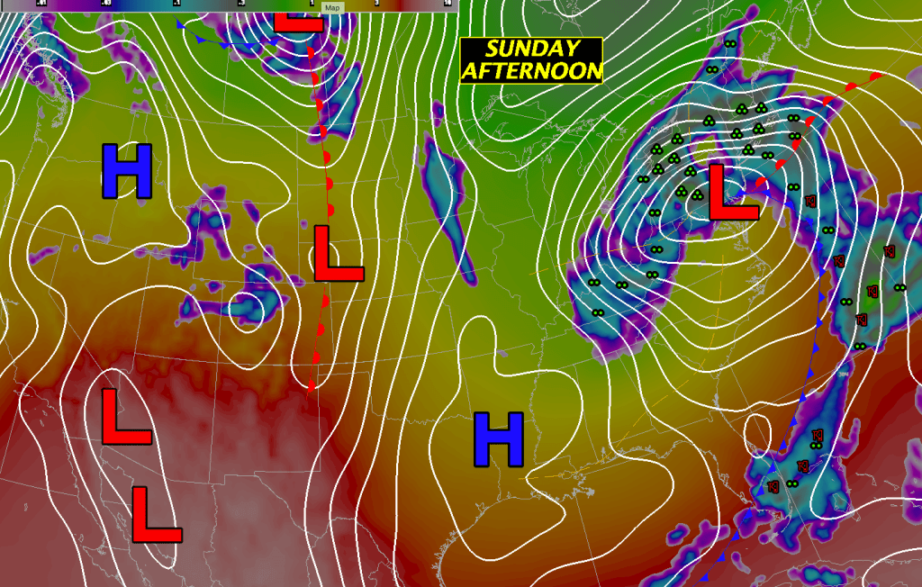
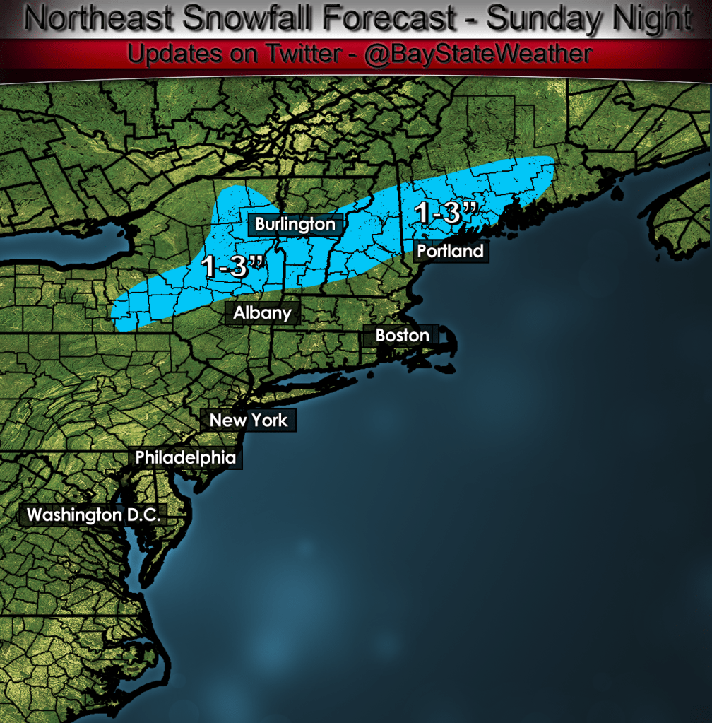
After the sun goes down on Sunday temperatures look like they may cool off quite a bit across southern and central VT, central and northern NH and Maine. This cooling may allow any rainfall that remains in New England overnight Sunday into Monday to change to snow. Right now I’m thinking that 1-3″ of snow may be possible from southern VT northeastward into central NH into interior Maine.
This storm will not get out of here quickly as the upper level low cuts off right on top of New England and allows clouds, showers and some steadier rain to linger through Tuesday morning.

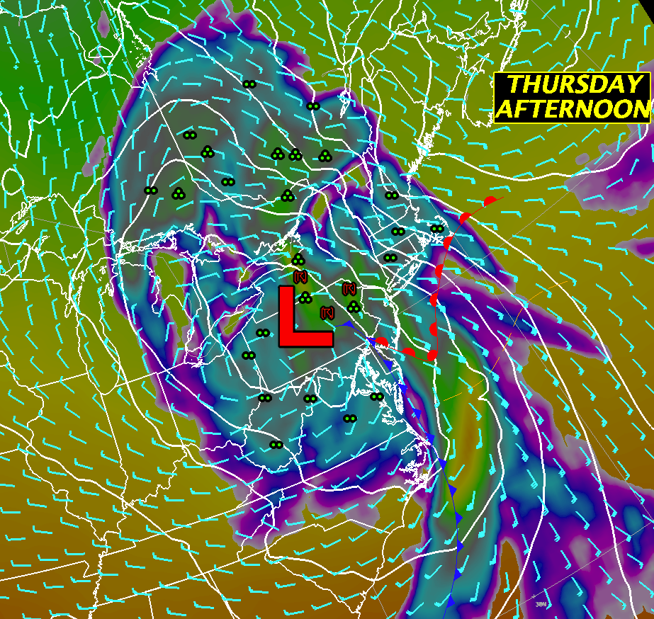
The Sun-Tue system finally gets out of here by Wednesday and will be replaced by a ridge of high pressure which will crest over us by Wednesday evening. After the crest of the high moves by, clouds will once again press into New England ahead of the next weather system which will bring yet another slug of about .50″ to .80″ of rainfall through us. There might be more unstable air associated with this system so we might hear a rumble of thunder or see a flash of lightning on Thursday evening.
By Friday there will be yet another upper level low lagging behind the Thursday system which will make our weather fairly unsettled with showers likely especially in the afternoon.
DETAILED FORECAST:
SATURDAY MORNING: Any localized fog in western MA and CT will burn off, becoming mostly sunny everywhere. Winds light and variable. Temperatures starting off in the low to middle 40’s rising into the 50’s toward the afternoon.
SATURDAY AFTERNOON: Mostly sunny everywhere. Winds SE 5-10 mph. High temperatures in the low to middle 50’s north, near 60 in Most of Maine, central and southern VT/NH and MA away from the coast and in the low 60’s CT/RI and SE MA. High Temperatures will hold in the low to mid 50’s along the coast from Boston to Portsmouth, NH.
SATURDAY NIGHT: Clouds moving in overnight. Winds light and variable. Low temperature 40-45 across central and southern New England. Low temperatures 32-40 across Maine and northern VT/NH.
SUNDAY: Cloudy with showers developing in the morning, steadier rain developing by afternoon. Rain becoming heavy at times. Winds E-NE 10-20 mph gusting 25-30 Boston and inland. E winds 15-30 mph gusting 35-45 mph Cape and Islands. High temperature 45-50.
SUNDAY NIGHT: Rain tapering off to showers or light rain in the evening and overnight. Cloudy and raw. Any left over rain may change to snow across southern VT, central NH and downeast ME. 1-3″ of accumulation are possible. Winds NE 10-25 gusting to 25-40 overnight strongest winds along the MA east coast and downeast ME. Low temperatures 30-40 degrees. Warmest across southern CT, RI, and Eastern MA. Coldest readings through central New England and Maine.
MONDAY: Cloudy with showers and light rain. It will be breezy and raw. Winds NE to N 10-20 gusting 20-30 mph with highest winds along the coast. High 40-45 except 45-50 in central and western CT. 32-40 south central NH into ME. Coldest temps in NW Maine.
MONDAY NIGHT: Showers and rain tapering off and ending toward morning. Winds N 5-15 mph gusting to 20-25 mph mostly in eastern sections. Light and variable winds west of the CT river valley. Low temperatures 32-40 except 25-30 in NW Maine.
TUESDAY: Cloudy with showers or light rain redeveloping. High in the mid 50’s east, low to mid 60’s in central and western MA. Winds 5-10 mph with gusts to 20 mph along south and east coasts of MA and ME. High temperatures 45-52, warmest SW CT.
TUESDAY NIGHT: Showers/rain ending with clouds thinning out and clearing overnight. Light and variable winds. Low temperature 35-40 in southern New England. 30-35 central New England. 25-30 across northern VT and NH and interior Maine.
WEDNESDAY: Sunny start with clouds increasing through the day. High temperatures 50-55 along the coast, 60-65 well inland.
THURSDAY: Cloudy with heavy rain especially later in the afternoon. Rumble of thunder? High temperature 50-55.
FRIDAY: Cloudy with showers likely. High temperature 60-65.
