Thursday Afternoon Weather Map
Issued Thursday April 30th @ 3:00 pm
WEATHER SUMMARY:
….ONE MORE STORM TO GO AND THEN SPRING FINALLY ARRIVES….
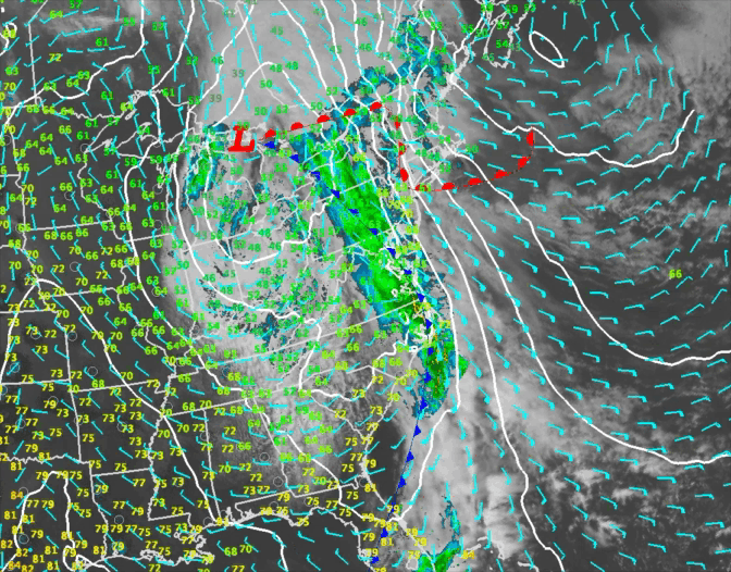
Low pressure, surface and aloft, moving through the Ohio Valley will push an area of rainfall into New England this evening and overnight. This should be a decent rain event with precip. water values of over 1.00″ advecting into New England by early Friday morning.
Rainfall amounts should be in the half to one inch range for much of SNE. There was disagreement among the models as to how progressive this system would be but that disagreement seems to have largely resolved and it appears this system is going to be out of here by Saturday morning. Once it’s gone, the weather settles down for a bit (finally!) and we get a stretch of mostly sunny days with seasonable or slightly above average temperatures over much of New England.
DETAILED FORECAST:
THIS AFTERNOON: Overcast with a few showers possible especially. through central MA. Steadier rain can be found in spots on a line from Rumford to Allagash, ME Highs 43-52 throughout New England except 53-60 over SW CT. Winds E- SE 10-20 mph with gusts up to 30 mph.
THIS EVENING/OVERNIGHT: Cloudy with spotty showers, especially to the north. Rain overspreading CT/VT and western MA by midnight. Into Eastern MA/NH/RI by 3-5 am. Winds SE 10-20 mph. Gusts 30-45 mph along the New England south coast and in northern ME, NH, VT, 25-35 mph across most of MA, central VT/NH, and along the Maine coast. Low temperatures 35-40 across interior ME/N. NH. 45-50 S NH/coastal ME and S VT 48-53 MA/RI/CT.
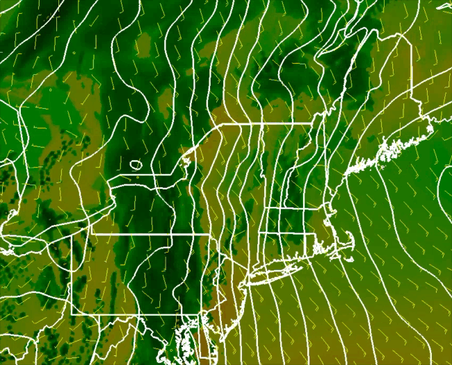
FRIDAY: Rain heavy at times especially in the morning NH/CT/VT/RI/MA. Rain developing and becoming heavy at times by afternoon in ME. Rain tapering off and ending by afternoon in VT/MA/CT/RI/NH. .50 – 1.15″ possible. SE winds 5-10 mph over CT/W MA/NH/ and interior ME. SE winds 15-25 mph along the MA/RI/ME coastline. SE winds 25-30 mph over Cape Cod. Gusts 25-35 RI/E MA/SE ME. Gusts 40-60 mph on the Cape. Highest winds through early afternoon diminishing after 2pm. High Temperatures 55-60 south and east facing coastal areas. 60-65 inland.
FRIDAY NIGHT: Rain tapering off and ending by early evening just about everywhere. Remaining mostly cloudy. Winds light and variable. Lows 45-50.
SATURDAY: Mostly Sunny. Highs 55-60 in northern ME, 60-65 across central and southern ME/N NH/N VT, 65-70 for the rest of the region.
SUNDAY: Mostly Sunny. Highs 60-65 throughout ME, 65-70 VT/NH/MA/RI, 70-75 in CT.
MONDAY:Mostly Sunny. 65-70 for southern New England, 62-67 across central New England, 60-65 N NH/VT, 55-60 Central and Northern Maine and northern VT/NH.
TUESDAY: Mostly sunny start, with some clouds moving in by afternoon. High temperatures in the mid 50-‘s north, low 60’s throughout SNE.
WEDNESDAY: Mostly sunny with highs near 60 in southern New England, mid 50’s in central New England and near 50 in northern New England.
THURSDAY: Partly cloudy, risk of a shower. Highs in the low 50’s across northern Maine, middle 50’s to near 60 from Portland, ME over to Concord, NH to Montpelier, VT. Low to middle 60’s across all of southern New England.
