Issued Monday May 4th @ 6:00 pm
WEATHER SUMMARY:
After a beautiful sparkling start to the day today, as forecast, we got stuck with cloudy overcast skies by afternoon. This was due to the movement of an upper level disturbance over New England. Combine that with unstable air and you’ve got clouds and even a few showers. As the sun goes down in the next 2 hours or so the overcast will begin to diminish and ultimately clear out, especially across southern New England. For northern New England the clouds will hang in a little longer.
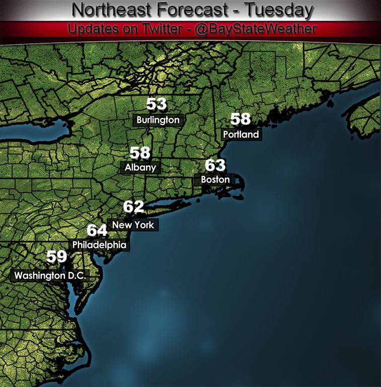
By tomorrow the cycle will start over again but mainly in northern New England. Southern New England should be mostly sunny and temperatures will rise to or slightly above 60 degrees.
Wednesday should be a pleasant day as well but clouds will be on the increase starting in SW sections in the morning advancing to the NH/VT/MA border by evening.
The next weather maker will be a coastal storm that will make its way across the waters SE of Cape Cod on Thursday morning. Looking it over this morning it seemed to me that there could be the potential for some frozen precipitation during Thursday but at this point I am reasonably sure that won’t happen. Looking at the model soundings during the time that the storm will pass SE of New England the air column throughout Southern New England (where most of the precipitation will fall) will be too warm especially in the lower 2000 feet of the atmosphere. In areas where we get some rainfall intensity there could be some mixing in of ice pellets but I think for the most part we are looking at some rain and not much beyond that.
Generally, beyond Thursday, it looks like weather systems riding along the jet stream will be on the weaker side and I’m not expecting any weather extremes.
DETAILED FORECAST:
THIS EVENING/OVERNIGHT: Decreasing clouds with skies clearing overnight in Southern and central New England. Mostly cloudy across NH, VT and ME. Rain or snow showers across northern sections. Winds NW 5-15 mph with gusts 20-30 mph. Low temperatures 35-40 most inland areas. 30-35 across far northern New England, 40-43 in the coastal cities.
TUESDAY MORNING: Mostly Sunny across southern New England, mostly cloudy everywhere else. Winds NW 10-20 mph with some higher gusts. Temperatures starting off in the low to mid 30’s at sunrise, rising through the middle to upper 40’s to near 50 across SE New England by late morning. Temps will hang back in the mid 30’s across northwestern parts of New England.
TUESDAY AFTERNOON: Continued mostly sunny across southern New England. Partly to mostly cloudy across central and northern NH/VT. Overcast across much of Maine. Rain/Snow showers possible across northern Maine. Winds NW 10-15 gusting 20-30 across the higher elevations of NH and ME. Highs near 60 in southern New England, upper 40’s to low 50’s through central sections. Low to middle 40’s through northern VT/NH. Around 50 for southern ME. 45-50 through central ME, near 40 through northern and western ME near the Canadian border.
TUESDAY NIGHT: Mostly clear to partly cloudy south to north. Winds light and variable just about everywhere. Low temperatures 25-30 across northern New England and the northern 2/3rds of Maine. 30-35 through much of VT/NH and western MA. 35-40 for the coastal plain.
WEDNESDAY: Sunny skies through the morning hours. Increasing clouds across CT/RI by late morning, clouds moving NE into the Boston area by late afternoon. Remaining partly to mostly sunny across NH/VT/ME. Winds E 10-15 mph in southern New England, light and variable, central and northern sections. High temperatures 55-60 along coastal locations, 60-65 away from the coast.
WEDNESDAY NIGHT: Overcast throughout all of southern New England. Mostly cloudy across central sections, clear in Maine north and west of Portland. Rain developing across CT/RI and SE MA. N-NE 10-15 mph except along the coast where winds should be 15-25 mph. Low temperatures 35-40.
THURSDAY: Cloudy with rain likely. Winds NNW 10-20 mph. High temperatures 50-55
FRIDAY: Partly Sunny. Highs in the mid 40’s north to the mid and upper 50’s south.
SATURDAY: Cloudy with showers. Highs 45-55.
SUNDAY: Partly Sunny, highs 40-50 north to south.
