Issued Monday May 11, 2020 9:30pm
WEATHER SUMMARY:
..BELOW NORMAL TEMPS TO START THE WEEK, WARMING UP BY THE WEEKEND…
…WARMER STILL NEXT WEEK?…
So we managed to squeeze out a few showers today as a storm system passed through northern New England. On the back side of this system we are going to have an anomalously cold system slide over us for a couple of days holding temperatures below normal for this time of year. We should have high temperatures near 70 around now but for Tuesday and Wednesday I think we’re going be lucky to crack 60, especially tomorrow as the core of the cooler air passes through.
Once we’re past Wednesday, we are in store for a major change in the weather pattern that will favor much above average temperatures in the eastern United States. Let’s dig into how that’s going to transpire.
To do this we have to look at the major features that drive how we experience our overall weather pattern here at the surface of the earth. To do that we need to look up. Our weather is largely driven by the high speed rivers of wind that blow at or above 18,000 ft. At that level there are eddies and waves that control the evolution of weather features near the surface. The eddies are often called “shortwaves” and the larger more dominant waves are called “longwaves”.
The distinction between long and short waves is very important. Short waves are small perturbations in the overall flow. Think of a flowing river. The river on a large scale is flowing from left to right (let’s say). As the river flows there will be small swirls that form in the larger flow. These eddies are relatively equivalent to “shortwaves” in the sense that we are talking about. The river itself is the long wave, or the generalized flow from left to right. When you take this and translate it onto a rotating frame (the earth) and then add the uneven heating of the earth between the equator and the poles the river tends to bend and weave. This bending and weaving is the attempt to balance the temperature differences. Those big bending and weaving waves (known formally as Rossby waves) are the “LONGwaves” that we refer to. Basically we are damping out all the shortwaves to reveal the undisturbed river aloft.
Whew, so what does that mean for the warm up Brian! I’m getting there. :). Lets look at a chart that damps out all the shortwaves:

Looking at the chart above you can see that we have a bunch of these waves. There are a lot fewer of them then you’d normally see on a 500 mb chart. That’s because we took away all the shortwaves.
You can see a large trough over the eastern half of the United States extending from a center over Hudson’s Bay in Canada and a ridge over the west. Troughs in this pattern are caused by the advection of cold air at the lower levels of the atmosphere which lowers the “height” of the atmosphere. When you analyze the data you get a chart that looks a lot like a topographical map where you have peaks and valleys of height.
The valleys in this context are created by cold air “lowering” the height and by warm air “raising” the height of the 500mb surface from the bottom up. These charts are very important to us weather geeks. They tell us, in large scale terms, where the colder and stormier and dry and sunnier weather will be.
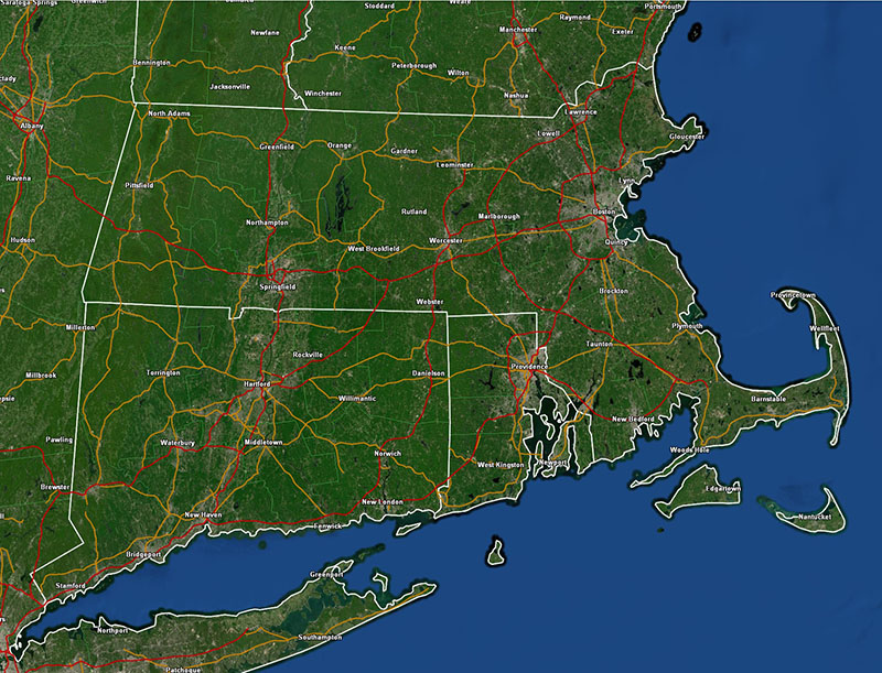
This chart, for Tuesday afternoon paints a very cool picture over the northern and eastern portion of the country.
So, after all that, we understand that the big trough over Hudson’s Bay in Canada means colder weather for us. Now, let’s fast forward to Thursday of this week.
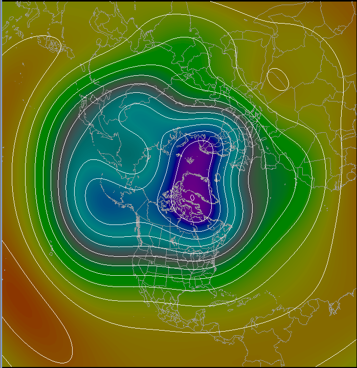
Looking at this chart we’ve got a big change on the way. The large cold trough over Hudson’s bay has diminished and retreated northward into Greenland. This has also allowed the heights to rise across the northern United States. As a result, moderating temperatures are allowed to move into the Great Lakes states and will begin to move into New England as the days go by. Now, let’s go out 10 days from today.
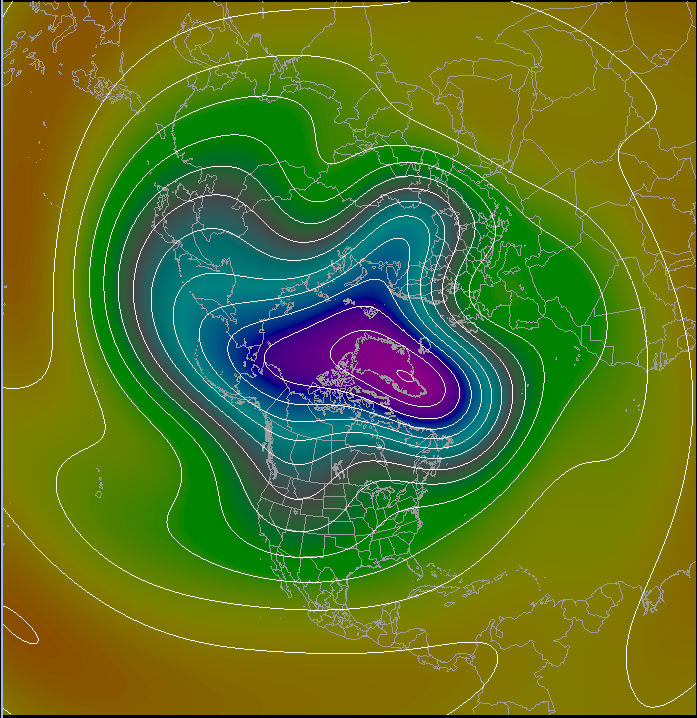
Wow, what a difference 10 days makes. The upper level pattern has completely changed around. The major trough that was keeping us cold has advanced out over the North Atlantic and Greenland. A ridge has replaced the trough in the eastern US and a trough has started digging in over the Western US. This pattern indicates a much warmer picture for the eastern US, with cooler temperatures for the west.
Now it’s important to remember that this is a 10 day forecast which are notoriously dodgy. The advantage, however, of using these 5 wave charts is that we are damping out all of the small features and we are just looking at the longwave pattern at 500 mb. Longwave features tend to be more stable and hold on for periods of a week or two as opposed to the more transient shortwave features. Forecasts of 500 mb height also tend to be a bit more reliable since you don’t need to contend with as much of the physics of the lower part of the atmosphere.
So the upshot of all of this explanation is that we are starting to look at a more spring/summer pattern as opposed to all this chilly stormy weather that we’ve had the last couple of weeks.
DETAILED FORECAST:
TONIGHT/OVERNIGHT: Cloudy with showers possible early. Shower activity ending by midnight. Becoming mostly clear toward sunrise. Winds W-NW 5-15 mph. Low temperature 35-40, near freezing in the Berks.
TUESDAY MORNING: Mostly Sunny and cool. Winds NW 5-10 mph. Temperatures starting in the mid 30’s to around 40 at sunrise, rising to 45-50 by noon.
TUESDAY AFTERNOON: Sunny. Winds W-NW 10-20 mph. High temperature 55-60.
TUESDAY NIGHT: Mostly clear to partly cloudy and cold for this time of year with risk of an overnight shower. Winds NW 10-20 with higher gusts. Low temperature 35-40 in the major cities, 30-35 outside of the major cities.
WEDNESDAY: Mostly Sunny. Winds NW 10-20 G 25-30. High temperature 55-60.
WEDNESDAY NIGHT: Clear winds W 5-10 mph. Low temperature 35-40.
THURSDAY: Mostly sunny. Winds W-NW 10-15 mph G 20. High temperature 65-70.
THURSDAY NIGHT: Increasing clouds, risk of showers overnight. Winds W turn SW then S overnight 10-15 mph. Low temperature 48-53.
FRIDAY: Partly cloudy and warm. Risk of a shower. Highs 65-70.
SATURDAY: Sunny and warm. Highs 70-75.
SUNDAY: Partly sunny and warm. Highs 70-75.
