Issued Wednesday May 13, 2020 6:00pm
WEATHER SUMMARY:
An upper level low exiting the northeast this evening is taking the core of this rather coolish air that we’ve had over us over the last few days with it. Replacing it is an area of high pressure building in from the Ohio Valley that will control our weather over the next 24 hour. As this high pressure area slides out over the Atlantic Ocean it will turn our winds into the SW by later on Thursday and this will allow a rather warm flow to set up over the East Coast on Friday.
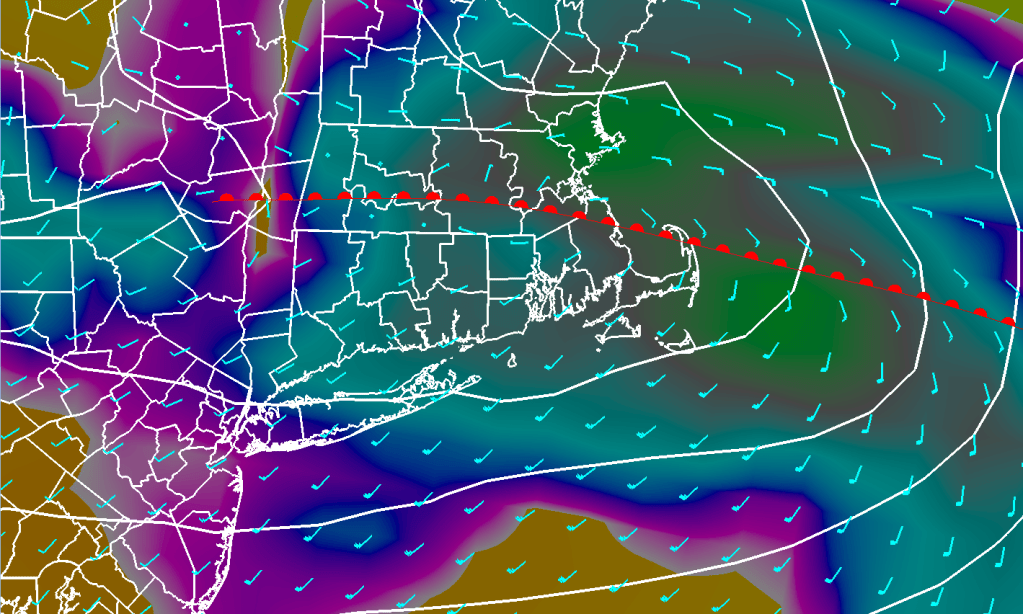
The forecast for Friday is a little bit tricky as there will be a warm front approaching during the early morning hours which will trigger showers and rain across much of SNE. The tricky part will be figuring if the warm front will make it north of SNE to allow us to break into the warm SW flow or keep us stuck in a considerably cooler E-SE flow Friday afternoon.

Based on the strength of the high pressure area out over the Atlantic on Friday and a strong west wind aloft I think this ought to help the warm front push through at least SNE. So, I’m going with highs in the low to middle 70’s on Friday with the full realization that the forecast could bust badly. I’m an optimist. :O). Obviously I’ll have to keep an eye on this and potentially make forecast revisions based on tomorrow’s model runs.
By late Friday into Saturday morning we can expect a period of rain as low pressure tracks across central New England. Once this low exits New England on Saturday morning we should dry out and clear out for Saturday. We should have a beautiful day with highs reaching the low 70’s over inland areas but holding in the low to middle 60’s near the east facing coastal areas. The remainder of the weekend should be OK with, once again, warmer temps inland and cooler temperatures along the coastline.
As we get toward Monday/Tuesday we are going to have to keep an eye on two major weather features. One is a storm system that will move through the Upper Great Lakes on Sunday and then into the northeast by Monday. This system may team up with what appears to be a sub tropical low pressure area moving northward parallel to the east coast during Monday. These two features could team up to give us a rather significant rainfall event toward the beginning of next week. The details of this are foggy and rely on a lot of small scale features that the models aren’t great at handling. We will be monitoring this in the coming days.
DETAILED FORECAST:
TONIGHT/OVERNIGHT: Clear winds W 5-10 mph. Low temperature 30-35 in the suburbs, 38-43 near Boston/Providence.
THURSDAY MORNING: Mostly sunny. Winds W 5-10 mph. Temperatures starting off in the 40’s just after sunrise, surging to near 60 by late morning.
THURSDAY AFTERNOON: Increasing cloudiness especially later in the afternoon toward evening. Winds SW turning S toward sunset 10-15 mph G 20-25. High temperature 65-70.
THURSDAY EVENING: Cloudy with rain developing toward midnight, continuing overnight. Winds S-SE overnight 10-15 mph. Low temperature 48-53.
FRIDAY: Mostly cloudy and warm. Risk of showers or thunderstorms especially by late afternoon. Winds S 10-20 with higher gusts. Highs 70-75.
FRIDAY NIGHT: Risk of a shower early in the evening then cloudy. Winds S-SE 10-15 shifting to the NW 5-10 after sunset. Low temperatures 52-57.
SATURDAY: Sunny and warm. Winds NW 12-18 mph turning E toward evening with a few higher gusts. Highs 70-75 inland, 60-65 by the coast.
SATURDAY NIGHT: Clear and cool. E-NE winds 5-10. Lows 43-48
SUNDAY: Mostly to Partly sunny and warm. Highs 55-60 at the coast 60-65 inland.
MONDAY: Rain, possibly heavy at times. Highs 50-55.
TUESDAY: Cloudy with showers. Highs 55-60.
