Issued Monday May 18, 2020 5:30pm
WEATHER SUMMARY:

Looking at the weather map this afternoon there isn’t too much on it of any concern. The devil, however, is always in the details. High pressure over southern Canada is pressing toward the southeast and will eventually push a backdoor cold front, now draped across central New England, to the south through Southern New England by tomorrow morning. When the backdoor front passes through it will turn winds everywhere into the NE and, hopefully also allow some slightly drier air to filter down from Canada. The east component of the wind may, however, keep Atlantic moisture and some level of low clouds in especially at the coastline during the next 48 hours or so. Temperatures will also be a challenge to forecast as where you are relative to the coast will determine just where your high temperatures will go each day. Areas close to the coast will hug the 50’s and perhaps low 60’s at times while interior New England should easily reach the mid 60’s and, especially by Wed/Thu, the low 70’s.
This cool maritime air mass will eventually be replaced by a warmer continental air mass by Friday as winds turn into the SW. I expect that 70’s to even the low 80’s will prevail across much of SNE then. That will be a treat.
Saturday and especially Sunday look to be cooler as clouds increase along with the increasing chance of a shower by Sunday.
For those of you wondering, Tropical Storm Arthur was off the NC coast this afternoon. Arthur is moving toward the NE and will continue to move in that direction through the next 24 hours. Arthur is not expected to represent a direct threat to land, but it will cause choppy 7-9′ seas along the southern New England coast as the storm passes to the south on Tuesday and Wednesday.

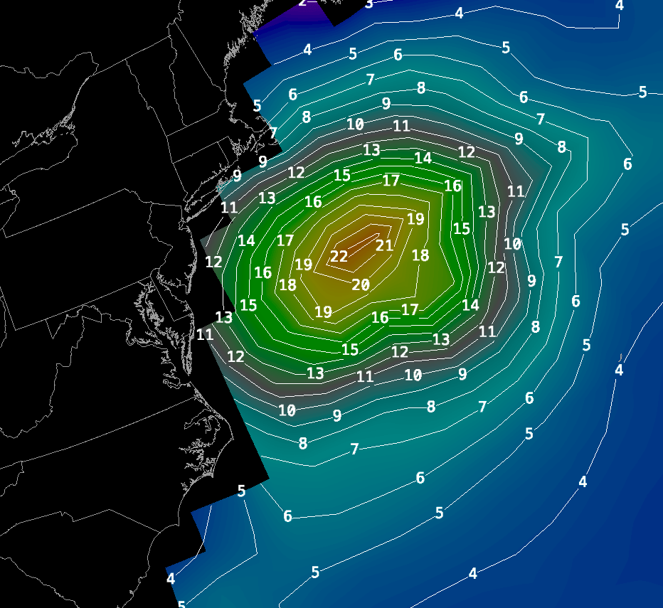
Right: Output from the WaveWatch model for Tuesday 2pm.
DETAILED FORECAST:
REMAINDER OF THIS AFTERNOON: Mostly cloudy. Winds E 5-10 mph. High temperatures 52-60 along the east facing coast, 60-65 inland, cooler in the Berks.
TONIGHT: Partly cloudy. Winds NE 5-10 mph. Low temperatures 45-52.
TUESDAY: A mix of sun and clouds. Winds NE 10-20 mph with gusts to 30 mph. Highs near 50 along the east facing coast. Mid 50’s to around 60 in eastern MA and along the south facing SNE coast, 60-65 central MA/CT/RI 55-60 in the Berks.
TUESDAY NIGHT: Partly to Mostly Cloudy. Winds NE 5-15 mph. Lows 42-47.
WEDNESDAY: A mix of sun and clouds near the coast, mostly clear everywhere else. Winds E 5-15 mph. High Temperatures 50-55 along the coast except 47-52 on the Cape, mid 50’s to lower 60’s east of Worcester and along the SNE south coast, mid 60’s central MA, low to mid 60’s in the Berks.
WEDNESDAY NIGHT: Mostly cloudy along the MA E coast/Cape Cod/Islands. Mostly clear skies inland areas. Winds calm. Lows 40-45 coastal areas, 30-40 across interior MA/CT/RI.
THURSDAY: Mostly Sunny and warm. S 10-15 mph. Highs 50-55 on the Cape, 55-60 along the south facing coast. 65-70 inside 128 and 70-75 through most of Central MA, 65-70 in the Berks.
THURSDAY NIGHT: Mostly clear. Winds SW 5-10 mph. Lows 42-47.
FRIDAY: Mostly Sunny. Highs 75-80.
SATURDAY: Partly cloudy. Highs 65-70.
SUNDAY: Cloudy with showers. Highs 55-60.
