Tropical Storm Cristobal continues its journey through the middle of the Gulf of Mexico on its way to the Louisiana coastline. The latest advisory from the National Hurricane Center indicates that Cristobal is 210 mi S-SW of the mouth of the mouth of the Mississippi River.
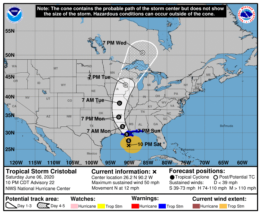
Cristobal has maximum winds of 50 mph and it is moving northward at 12 mph.
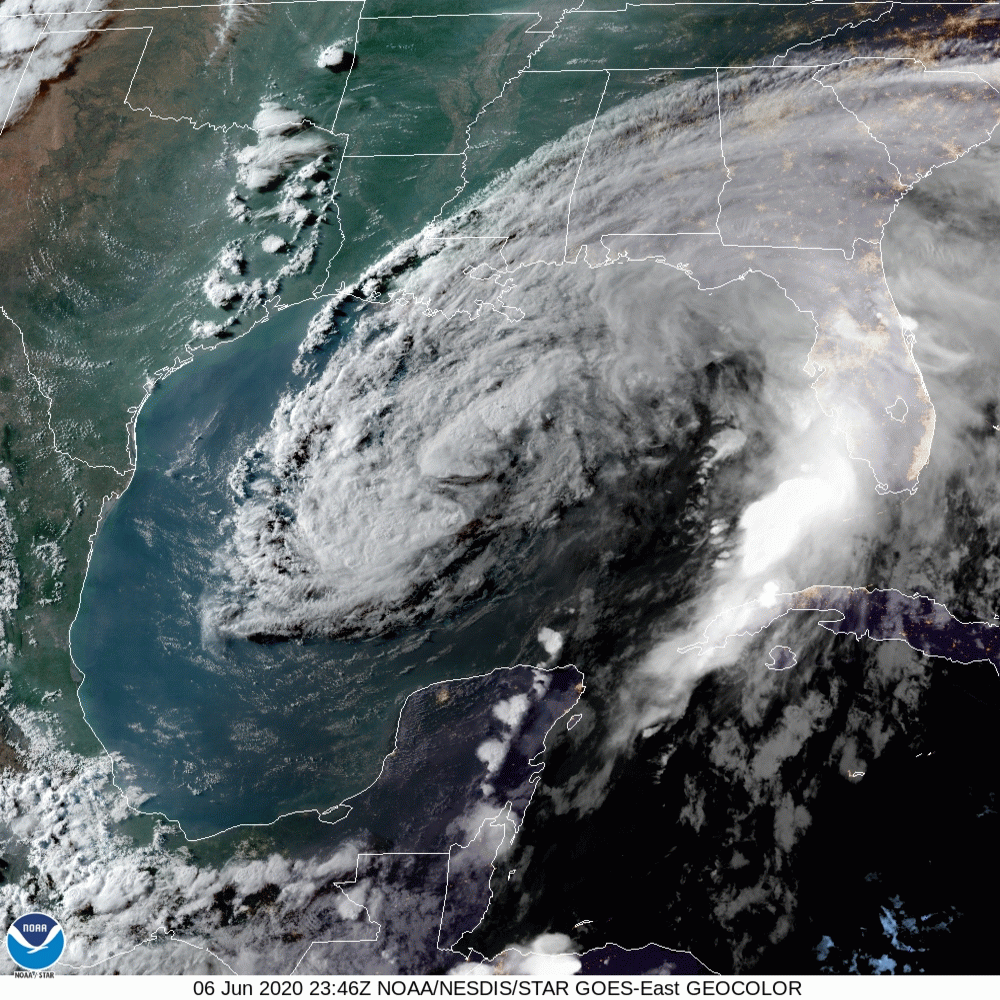
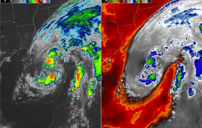
Looking at the satellite loop Cristobal is not a very impressive system. He does have a fairly well structured low level circulation but not very well organized deep convection near the center of the circulation. You need this to allow a tropical system to intensify, hurricanes are essentially large convection driven heat engines. The fact that there isn’t much organized convection near the center argues for a weaker system at landfall.
The other thing that Cristobal is fighting off is dry air to the west and south of the storm that is entrained into the circulation of the storm. This is also preventing Cristobal from becoming better organized as the dry air inhibits the formation of thunderstorms and starves the storm of the heat energy that is generated by that process.
Further, the sea surface temperatures that Cristobal is moving over are around 27C which is the minimum temperature needed to maintain a tropical system. Lastly, there is wind shear in the vicinity of Cristobal. If you look at the northern portion of the storm’s circulation you can see the wind blowing the cloud formation rapidly from southwest toward the northeast. This wind shear is disrupting Cristobal’s circulation. Hurricanes cannot develop in an atmosphere with large amounts of wind shear in the environment.
The end result will be that Cristobal will not strengthen very much, if at all, before he reaches the Louisana coast. Cristobal should be a 50-60 mph tropical storm at most as it makes landfall.
So, what will the ultimate impacts of Cristobal be?
TIMING: I believe that Cristobal will reach the south coast of Louisiana by 7-9pm on Sunday. The models are in pretty unanimous agreement on this timing so I feel pretty confident in that forecast.
STORM SURGE: The storm surge guidance is indicating that 3-5′ storm surge is likely especially from the mouth of the Mississippi River up the coastline to Ocean Springs, MS. This is reflected in the 10pm CDT NHC advisory. It seems like the focus of the surge will be from 5pm Sunday – 5am Monday from Pearlington, MS to Biloxi, MS.
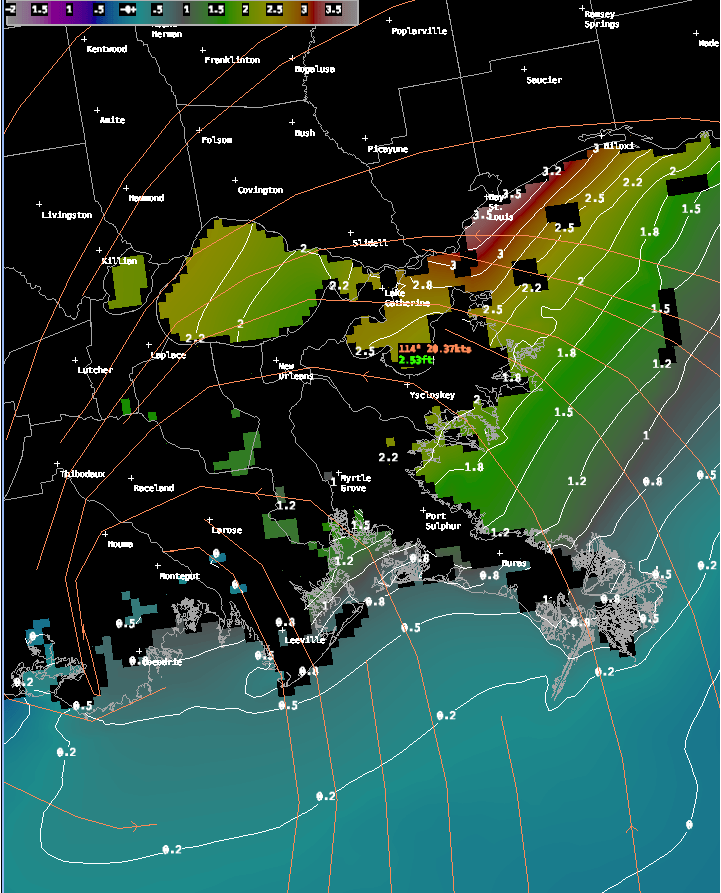
In particular it looks like Bay St. Louis will pile up the water most efficiently as the wind direction will be blowing right into the mouth of the bay during landfall. Dangerous coastal inundation is possible. The other area of concern will be on the north side of Lake Pontchartrain during Monday morning where 2-4′ storm surge is possible. If this area is not well protected flooding may be possible in that area as well.
WINDS: Wind should not be a major factor with this storm system. This system is rather atypical of a stronger tropical storm or hurricane in that the strongest winds are displaced far out from the center of circulation. This is due to the disorganized state of this storm and I don’t expect that will improve much by tomorrow night. Winds along the coast may reach 40-50 mph east of the storm center along the MS coast with higher gusts up to 55-65 mph possible.
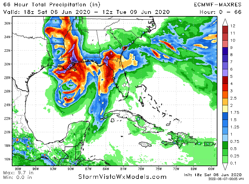
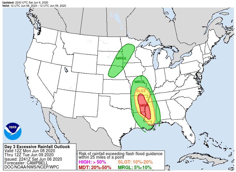
RAINFALL: Excessive rainfall is likely with Cristobal. The models have been bouncing back and forth on where the bullseye of the heaviest rain will be. It appears that there will be a general area of 5-8″ of rainfall focused on the eastern portion of Louisana around New Orleans eastward to the MS/AL border. Locally higher amounts, up to 10″ may be possible within this area. There is significant flooding potential with this kind of rainfall.
TORNADOES: Landfalling tropical systems tend to spawn tornadoes as the circulation interacts with the land and frictional forcing causes turbulence and rotation. These spin ups are scattered in nature and can take place at any time. The greatest risk for these spin up storms are on the west coast of the Florida panhandle and the SE portion of Louisana close to the mouth of the Mississippi River. This risk may spread into interior Mississippi during Monday.
INLAND EFFECTS: Heavy rain will move inland after Cristobal comes ashore and vast swaths of the midsection of the country could see rainfall amounts in excess of 4″ especially from southern Mississippi through southern Missouri. The potential for flash flooding will be elevated throughout this area.
Stay tuned for further blog updates. If you are reading this from a threatened area, please consult official sources if you need to make decisions concerning life and property.
