Forecast Issued Monday December 30th, 2024 @ 9:15 am
****FORECAST UPDATE****
Issued Friday 20 Dec 2024 @ 5:00pm
Southern New England Forecast December 19, 2024

Forecast Issued: December 19, 2024 @ 2:00am
Detailed Forecast:
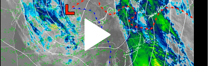
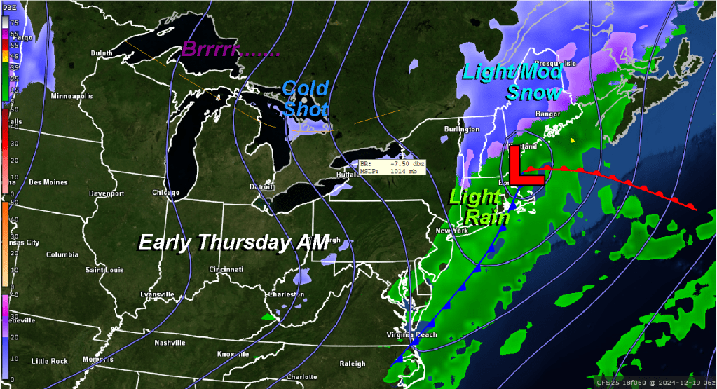
Overnight: Rain occasionally moderate at times with the heaviest amounts of rain across SE MA, RI and SE CT. Winds Light and Variable becoming W-NW 10-15 mph G 20-25 mph Temperatures 35-40 in far western areas of MA/CT and Southern VT/NH, 40-45 in and around the metro Boston area and 45-50 SE MA/RI and Cape Cod.
Thursday Morning: Rain ending before sunrise and then becoming mostly clear after sunrise. NW winds 10-15 mph gusting to 20-25 mph, winds a bit higher over the Cape. Morning temperatures holding steady in the upper 30’s to mid 40’s early then dropping into the afternoon.
Thursday afternoon: Mostly sunny early afternoon but becoming partly cloudy toward sunset. NW winds diminishing to 5-10 mph most areas except Cape Cod where winds will hold up to around 10-20 mph gusting to 25-30 mph. Temperatures settle back to 30-35 in the west, 35-40 central MA/CT and RI, 40-45 Metro Boston to the Cape.
Thursday Evening/Overnight: Clear and cold for the most part but a high overcast may develop toward SE MA and the Cape. Temperatures falling to 30-35 degrees generally. Morning low temperatures will settle to around 25-30 degrees west to east.
Friday: Starting off bright but clouds quickly move in by afternoon. Mostly cloudy with the risk of evening/nighttime snow showers. Highs temperatures will be 35-45 in eastern MA, Cape Cod and RI. 25-35 out over central and western areas of MA/CT, S VT, S NH.
Saturday: Cloudy with the chance of light snow mainly over Cape Cod and the islands up to a Boston/Providence line. 1-3″ possible over far SE MA and the Cape, less than one inch Metro Boston to Metro Providence. Some snow squalls and light snow might also bring up to 2-4″ across southern VT and a coating of snow into the Berkshires. High temperatures 30-35 with a few spot temperatures higher over Cape Cod.
The Morning Update

Southern New England Forecast 12/16/2024

Forecast Issued: Monday, December 16, 2024 8:45 pm

Overnight (12/16): Mostly Cloudy with the risk of a shower or two early and then light rain develops overnight. Temperatures holding steady or rising through the 40’s especially overnight and toward sunrise. Winds increasing to SE 10-15 mph in western sections with higher gusts in the hilly terrain of Worcester County and northern CT overnight. Becoming more brisk out of the southeast over eastern and SE sections of MA especially over Cape Cod and the islands 10-20 mph mph gusting to 25-35 mph especially along the coast.
Tuesday Morning (12/17): Light rain through the early morning hours which should end shortly after sunrise. Temperatures in the upper 40’s to low 50’s. Winds turning S-SW to SW 10-20 mph gusting to 20-35 mph especially along the coast.
Tuesday Afternoon (12/17): Clearing skies developing from west to east across the area. High temperatures 55-60 with the warmest readings in central CT. Winds SW to W diminishing to 5-15 mph gusting to 20-25 mph.
Tuesday Night: Mostly clear with temperatures dropping off into the low to mid 40’s over eastern portions of MA and RI, upper 30’s to lower 40’s west and north. Winds W 5-10 mph.
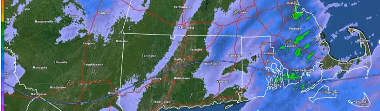
Wednesday (12/18): Filtered sunshine early giving way to thickening and lowering clouds by afternoon. Overcast by evening with rain developing and continuing overnight. Wednesday morning low temperature 30-35 near the cities, 25-30 in the suburbs. High temperatures 45-50.
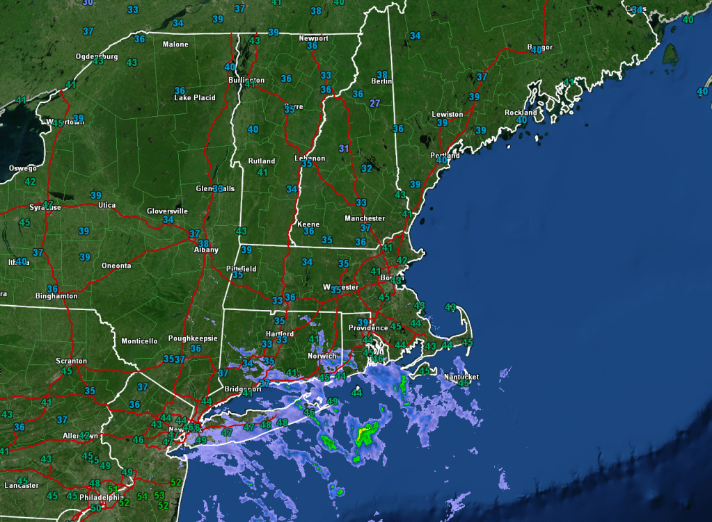
Thursday (12/19): Light rain perhaps mixing with a little snow, especially west and north first thing in the morning, then becoming mostly sunny, blustery, and cold. High temperatures near 32 degrees.
SNE Forecast: Monday Afternoon Update
Issued Monday December 16, 2024 @ 2:00pm

Today’s forecast is verifying reasonably well as the clouds have overrun the area according to expectations last night. There was a period of light rain, mainly across CT and RI, during the wee hours of this morning, but it wasn’t very long-lived and has mostly dried out with the exception of a little bit of light rain along a Bridgeport, CT to New Bedford, MA line. Otherwise, the area is mostly dry. Temperatures, for the most part, are behaving themselves with just a few mid-40s creeping into S RI, far SE MA, and the mid-Cape and Islands. This is in response to a warm front that pushed northward along the southern coast of CT/RI into SE MA.

Other than that, the forecast is doing pretty well this afternoon and not much change is expected.
Have a great Monday!
The Extended Outlook
Issued Sunday, December 15, 2024, @ 10:10 PM
Friday (12/20): Partly cloudy and cold with the chance of a snow shower. Highs near 30 east, middle 20s west/north.
Saturday (12/21): Partly to mostly cloudy, especially for SE MA and Cape Cod; risk of snow showers along the coastline, especially the Cape and Islands. Highs 25-30
Sunday (12/22): Partly sunny and breezy. Highs 22-27
Monday (12/23): Mostly sunny. Highs 22-27 throughout much of MA / 25-30 Cape Cod and CT/RI.
Tuesday (12/24): Cloudy with the risk of a rain or snow shower. Warmer with highs in the mid to upper 30s.
Wednesday (12/25): Cloudy, risk of a shower. Highs near 40.
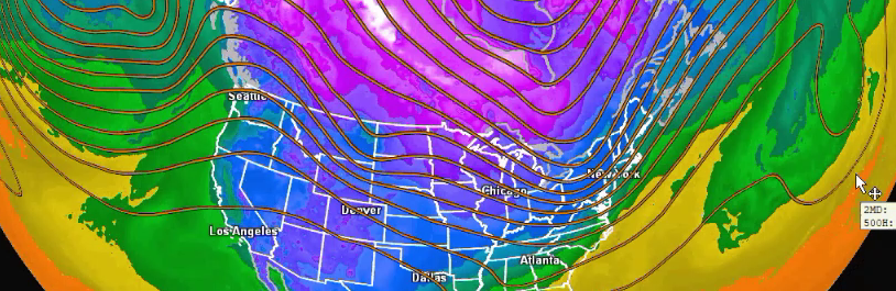
Long Range Outlook:
Upper-level ridging is expected to develop along the east coast after Christmas Day, which should promote a continuation of the warming trend that starts on Christmas Eve. The vacation week between Christmas and New Year’s should feature above-average temperatures for this time of year, ranging from the 40s into the 50s. We could even see temperatures near 60 during this time, especially during or around the weekend before New Year’s Eve/Day.
Southern New England Forecast
Forecast Issued: Sunday, December 15, 2024 8:32 pm
Overnight: Increasing Clouds with light winds . Temperatures near freezing in the city 25-30 in the burbs.
Monday Morning: Cloudy with winds light and variable becoming E-SE 5-10 mph but light and variable over western sections of SNE. Temperatures ranging from 30-35 near Boston down to 25-30 N & W of 495.
Monday Afternoon: Mostly cloudy with temperatures rising into the low 40’s over most of eastern MA/RI/E CT but holding in the mid 30’s across northern Worcester county and in the Berkshires. Winds continuing light and variable west of Worcester/Hartford up into Southern NH/VT. SE 10-15 mph over eastern and southeastern parts of the area.
Monday Evening: Mostly Cloudy with the risk of a shower or two early and then light rain develops overnight. Temperatures holding steady or rising through the 40’s especially overnight and toward sunrise. Winds increasing to SE 10-15 mph in western sections with higher gusts in the hilly terrain of Worcester County and northern CT overnight. Becoming more brisk out of the southeast over eastern and SE sections of MA especially over Cape Cod and the islands 10-20 mph gusting to 25-35 especially along the coast.
Tuesday: Light rain through the early morning hours which should end shortly after sunrise. Low temperatures near 40 in the city 35-40 in the burbs and western sections. High temperatures will reach into the upper 50’s during Tuesday afternoon. Winds turning S-SW 5-15 gusting to 20-40 especially along the coast.
Wednesday: Filtered sunshine early giving way to increasing clouds by afternoon. Overcast by evening with rain developing. High temperatures near 50 degrees.
Southern New England Forecast
***NEW FEATURE! You can get these forecasts and blog entries delivered directly to your e-mail. Click the button at the bottom of this post to subscribe!***
Issued: Friday June 12 2020 6:00 am
3-DAY FORECAST:
TODAY: Some morning clouds then becoming mostly sunny with much lower humidity. Winds W-SW 5-10 with some gusts up to 20 mph. High temperature 80-85, 75-80 upper and mid Cape, 68-75 outer cape.
TONIGHT: Partly cloudy with very comfortable humidity. NW winds 5-10 mph. Low temperature 55-60 in eastern MA/RI, 50-55 central MA/CT, cooler in the Berkshires.
SATURDAY: A mix of clouds and sun. Winds light and variable. High 72-77.
SATURDAY NIGHT: A few clouds here and there. Light winds. Lows 50-55 E. MA, 45-50 central sections, 40-45 western MA/Berks.
SUNDAY: Variable clouds with low humidity. High 70-75 except 65-70 on the Cape.
EXTENDED FORECAST:
MONDAY: Mostly Cloudy. High 70-75.
TUESDAY: Partly sunny with a high 75-80.
WEDNESDAY: Partly sunny. High around 80.
THURSDAY: Mostly cloudy. High 82-87.
Southern New England Forecast
***NEW FEATURE! You can get these forecasts and blog entries delivered directly to your e-mail. Click the button at the bottom of this post to subscribe!***
Issued: Thursday June 11 2020 6:00 am
3-DAY FORECAST:
TODAY: Cloudy and quite muggy with the risk of a shower or thunderstorm during the afternoon. Winds SW 10-15 mph with gusts 25-30. Highs 70-75 southern CT/RI/South Coast/Cape and Islands. 75-80 elsewhere.
TONIGHT: Mostly cloudy with some partial clearing toward sunrise. Winds SW becoming light and variable. Low temp 60-65 eastern MA/RI/E CT. 55-60 western MA/CT.
FRIDAY: Partly to mostly sunny with much lower humidity. Winds W-SW 5-10 with some higher gusts. High temperature 80-85, 75-80 upper and mid Cape, 70-75 outer cape.
FRIDAY NIGHT: Mostly clear. NW winds 5-10 mph. Low temperature 55-60, cooler in the Berkshires.
SATURDAY: Partly sunny. Winds light and variable. High 75-80.
EXTENDED FORECAST:
SUNDAY: Partly cloudy with low humidity. High 70-75.
MONDAY: Mostly Cloudy. High near 70.
TUESDAY: Partly cloudy with a high near 75.
WEDNESDAY: Partly cloudy. High 75-80.
