Southern New England Forecast

***NEW FEATURE! You can get these forecasts and blog entries delivered directly to your e-mail. Click the button at the bottom of this post to subscribe!***

Issued Wednesday May 20 2020 11:30 pm

WEATHER SUMMARY:

As we pass through mid week the weather story is looking a bit warmer during the next 48 hours as the weather pattern gradually shifts. The high pressure cell that was sitting to our north is now east of New England and this is allowing winds to gradually change around.

8pm Wednesday Surface Weather Map and Satellite Image

By this afternoon our winds will turn into the southwest and this will allow temperatures away from the coast line to rise into the low to middle 70’s. As we move through Thursday night and on into Friday high pressure will then shift to the SE of New England and allow winds just about everywhere to turn into the SW.

Friday afternoon Temperatures

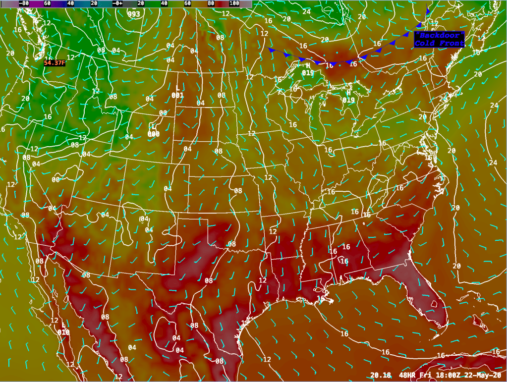
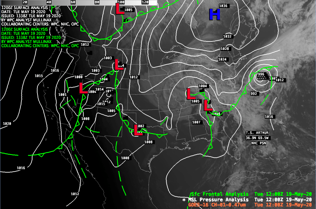
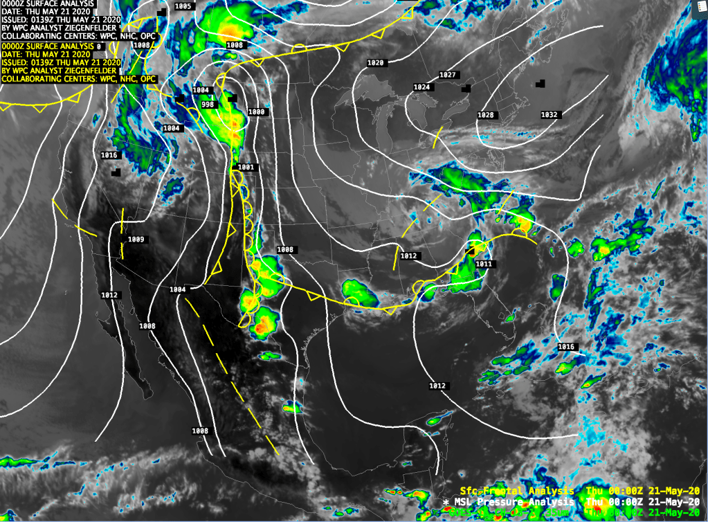
This will allow temperatures to rocket up into the upper 70’s to the lower 80’s in some spots, even near the coast. As you look at Friday’s surface chart above, notice the cold front in southern Quebec and Ontario. This cold front will come at us from the NE during Friday night and push through Eastern MA and RI by Saturday afternoon.

Saturday Morning Surface Weather Map – 8am

When this front passes through our winds will flip into NE in most locations and this will hold temperatures down as we bring cool air back in from the Atlantic Ocean. The cool maritime Canadian air will stick with us through Sunday.

Then, high pressure will build back up east of New England on Monday and especially on Tuesday/Wednesday which will allow winds to turn into the south and temperatures will respond by moving back into the mid 70’s except at the south facing coast line.

DETAILED FORECAST:

OVERNIGHT: Mostly clear. Winds calm. Lows 40-45 coastal areas, 35-40 across interior MA/CT/RI.

THURSDAY: Mostly Sunny and warm. S 10-15 mph. Highs mid 50’s on the Cape and along the south facing coast. Near 70 inside of 128 and on the south shore, 70-75 through most of Central MA, and 65-70 in the Berks.

THURSDAY NIGHT: Mostly clear. Winds SW 5-10 mph. Lows 45-50.

FRIDAY: Mostly Sunny. Winds SW 5-10 mph. with higher gusts up to 20 mph. Highs 60-65 on Cape, 65-70 along the CT and RI coasts, 70-75 interior CT/RI/MA South Shore, 75-80 throughout much of MA except in the Berks where temperaures will hold in the lower 70’s.

FRIDAY NIGHT: Increasing clouds. Winds Calm. Lows 55-60.

SATURDAY: Cloudy with showers especially to the south of the Mass Pike. Winds becoming E 10-15 with gusts up to 25 mph. Highest winds in E MA/E CT/RI. Highs around 65 inside 128 by late morning then temperatures will fall into the upper 50’s. 55-60 on Cape Cod, west of 128, through RI and CT afternoon highs will be 65-70 and west of Worcester but east of the Berks and north of the Pike temperatures will rise to near 75.

SATURDAY NIGHT: Becoming mostly clear. Winds NE 5-15 mph. Lows 43-50.

SUNDAY: Mostly Sunny. Highs 50’s over the cape, low 60’s near Boston, 65-70 western MA and CT.

MONDAY: Mostly Sunny. Highs 70-75 except cooler at the coasts.

TUESDAY: Partly Sunny. Highs 72-77, cooler coast.

Hey! Wasn’t it supposed to warm up?!

Issued Tuesday May 19 2020 12:00pm

I can hear you out there now. Where is the %^&^$^%( warm weather!

Patience young Jedi….warm weather is on the way though it is delayed a little bit.

A few forecast posts ago I spoke about the pattern change that we were looking at in the long term. I gave a rather extensive explanation about long and short waves and how they influence the weather pattern in the short and long term. Well, all of that still applies. Additionally, just like the check in the mail, the warm weather is on the way.

First, let’s look into why we are still so cool. You need not go too far to figure it out either. Let’s look at this morning’s weather map:

8am Surface Map and Visible Satellite Image

The surface map from 8am shown above paints the chilly picture over the northeastern United States. A large high pressure area over Quebec, which will press toward the SE over the next 48 hours is pumping some rather cool maritime polar (mP) air into the northeast. Add this to a persistent long fetch E-NE wind which is blowing over sea surface temperatures which are in the middle to upper 40’s and you’ve got the recipe for temperatures to be well below seasonal norms. This pattern is a smaller scale low level phenomena as opposed to the larger scale trends we were talking about last week.

What do those larger scale features tell us about our weather? Have they changed? Let’s take a look:

Looking at the two charts above we see that the longwave pattern looks largely like we thought it would. So, on average, given the 500 mb pattern presented we would expect above average temperatures in the east and cooler than average temperatures in the western part of the country. The devil, as they say, is in the details.

The details can be found on the right most chart which represents the 500 mb forecast with short and long waves included. The heavy pinkish line that I’ve drawn on the chart shows where the main 500 mb flow is. As you can see, it looks a lot like the 500 mb long wave pattern shown on the left. What does that mean? It means that the 500 mb long wave pattern that we were talking about last week has evolved exactly as we thought. So why isn’t it warm?? Details…..details. The chart on the right helps to explain why the pattern is the way it is. First, we have what we call a “cut off” low floating over the Tennessee Valley/Ohio Valley region of the country. We call it a “cut off” low quite literally because it is cut off from the main upper level low. This cut off represents a pool of cool air at mid and upper levels of the atmosphere. This kind of low pressure area allows cool and rainy/showery weather to persist over an area over extended periods. Cut off lows tend to form at this time of year as the upper atmosphere is still rather cool from the winter months. As a result, its easier for these cold pools to develop and split away from the main upper level flow. Cut off lows also take a while to exit an area mainly because they are seperated from the primary upper air flow. Essentially, there is nothing to move them along. This cut off, basically gumming up the upper air flow, and the cold canadian high pressure area, which will persist over us for a bit, will combine to keep us in the cool, kind of moist but not that cloudy flow through Wednesday.

So, how does the combination of all these factors influence surface weather?

Looking at today’s high temperature map you can see that is pretty cool over much of the Eastern and Central United States. These cool conditions are a response to the upper level cut off low over the Tennessee Valley and the cool maritime polar air flow coming down from the high pressure to the north of New England. The only warm place in the eastern part of the country is the far SE and Florida panhandle where temperatures are in the mid 80’s to lower 90’s which is about average for this time of the year.

Notice, however, that there is a stretch of rather warm air from Texas right up the spine of the Central and Northern Plains states. This is an expression of the influence of the long wave ridging that is present despite the cool pool that exists over the east. You can also see the cooler weather over the Western United States which is also reflective of the long wave pattern. So, it stands to reason that if we got rid of the transient cut off low pressure area that temperatures would start to respond and warm up. Well, that’s exactly what happens.

By Friday the upper level pattern begins to change as the cut off low gradually fills and becomes an open wave which will allow it to reintegrate all that upper level energy back into the general west to east flow.

On Friday (shown above) we’ve got warming temperatures throughout the east and northeast (except where it will be raining throughout the Mid-Atlantic states). Temperatures in the 80’s and 90’s will expand into the south and Florida will see above normal temperatures especially in the central sections of the state.

So, bottom line, keep the faith. Warmer weather is baked into the current pattern and we will see it. We just need to get the winds to stop blowing over the giant fridge to our east. 🙂

Southern New England Forecast

Issued Monday May 18, 2020 5:30pm

WEATHER SUMMARY:

2pm Surface Analysis with Radar and Visible Satellite

Looking at the weather map this afternoon there isn’t too much on it of any concern. The devil, however, is always in the details. High pressure over southern Canada is pressing toward the southeast and will eventually push a backdoor cold front, now draped across central New England, to the south through Southern New England by tomorrow morning. When the backdoor front passes through it will turn winds everywhere into the NE and, hopefully also allow some slightly drier air to filter down from Canada. The east component of the wind may, however, keep Atlantic moisture and some level of low clouds in especially at the coastline during the next 48 hours or so. Temperatures will also be a challenge to forecast as where you are relative to the coast will determine just where your high temperatures will go each day. Areas close to the coast will hug the 50’s and perhaps low 60’s at times while interior New England should easily reach the mid 60’s and, especially by Wed/Thu, the low 70’s.

This cool maritime air mass will eventually be replaced by a warmer continental air mass by Friday as winds turn into the SW. I expect that 70’s to even the low 80’s will prevail across much of SNE then. That will be a treat.

Saturday and especially Sunday look to be cooler as clouds increase along with the increasing chance of a shower by Sunday.

For those of you wondering, Tropical Storm Arthur was off the NC coast this afternoon. Arthur is moving toward the NE and will continue to move in that direction through the next 24 hours. Arthur is not expected to represent a direct threat to land, but it will cause choppy 7-9′ seas along the southern New England coast as the storm passes to the south on Tuesday and Wednesday.

DETAILED FORECAST:

REMAINDER OF THIS AFTERNOON: Mostly cloudy. Winds E 5-10 mph. High temperatures 52-60 along the east facing coast, 60-65 inland, cooler in the Berks.

TONIGHT: Partly cloudy. Winds NE 5-10 mph. Low temperatures 45-52.

TUESDAY: A mix of sun and clouds. Winds NE 10-20 mph with gusts to 30 mph. Highs near 50 along the east facing coast. Mid 50’s to around 60 in eastern MA and along the south facing SNE coast, 60-65 central MA/CT/RI 55-60 in the Berks.

TUESDAY NIGHT: Partly to Mostly Cloudy. Winds NE 5-15 mph. Lows 42-47.

WEDNESDAY: A mix of sun and clouds near the coast, mostly clear everywhere else. Winds E 5-15 mph. High Temperatures 50-55 along the coast except 47-52 on the Cape, mid 50’s to lower 60’s east of Worcester and along the SNE south coast, mid 60’s central MA, low to mid 60’s in the Berks.

WEDNESDAY NIGHT: Mostly cloudy along the MA E coast/Cape Cod/Islands. Mostly clear skies inland areas. Winds calm. Lows 40-45 coastal areas, 30-40 across interior MA/CT/RI.

THURSDAY: Mostly Sunny and warm. S 10-15 mph. Highs 50-55 on the Cape, 55-60 along the south facing coast. 65-70 inside 128 and 70-75 through most of Central MA, 65-70 in the Berks.

THURSDAY NIGHT: Mostly clear. Winds SW 5-10 mph. Lows 42-47.

FRIDAY: Mostly Sunny. Highs 75-80.

SATURDAY: Partly cloudy. Highs 65-70.

SUNDAY: Cloudy with showers. Highs 55-60.

Special Forecast Update

Issued: Sunday May 17 2020 12:15 pm

When people ask me why I’ve lost so much hair, I give them one simple answer….”weather forecasting”. Yes, today is one of those hair pulling days forecasting New England weather. We are oh so lucky to have that dripping in moisture….gigantic refrigerator (at this time of year) called the Atlantic Ocean immediately to our east. The good ole Atlantic managed to take some of its low level moisture and spit it back at us during this morning in the form of a low to middle cloud deck that fouled up the supposedly mostly sunny day I forecast for today. Oh the joys of forecasting the weather in New England in the spring.

Fear not, however, some of Sunday (a misnomer…..”Sun”day) will be salvaged as the satellite loop does show that the low level moisture is eroding and some partial clearing will be possible by a little later this afternoon. This should allow temperatures to get up into the low 60’s today along the coast and into the middle to upper 60’s inland. We’ll take it.

Arthur is Born

At 11pm last night the National Hurricane Center named Tropical Depression #1 “Arthur”. The current position fix of Tropical Storm Arthur is:

SUMMARY OF 1100 AM EDT…1500 UTC…INFORMATION

LOCATION…30.5N 77.4W
ABOUT 345 MI…550 KM SSW OF CAPE HATTERAS NORTH CAROLINA
MAXIMUM SUSTAINED WINDS…45 MPH…75 KM/H
PRESENT MOVEMENT…NNE OR 15 DEGREES AT 9 MPH…15 KM/H
MINIMUM CENTRAL PRESSURE…1002 MB…29.59 INCHES

On satellite Arthur’s presentation is a bit ragged with very little deep convection near the center. There is, however, a well defined low level circulation. Arthur’s convection should pep up a little later today with the heating of the sun, favorable SST’s and relatively low wind shear. Satellite imagery shows decent outflow in the northern, western, and southern quadrants of the storm. There may be a little bit of SW shear staunching the outflow to the east of the storm center. On the whole, I don’t expect Arthur to strengthen much if at all over the next 24 hours.

Arthur’s track will take him to just off Cape Hatteras, NC by tomorrow morning and then he will take a sharp right turn passing harmlessly out into the Atlantic by Tuesday morning.

Tropical Depression #1 Has Formed

At 5:00pm the National Hurricane Center designated the disturbance off the Florida east coast as Tropical Depression #1 (TD #1), the first official tropical system of the not even officially started Atlantic hurricane season.

Here is the position fix of TD#1:

SUMMARY OF 500 PM EDT...2100 UTC...INFORMATION
----------------------------------------------
LOCATION...28.4N 78.6W
ABOUT 125 MI...200 KM E OF MELBOURNE FLORIDA
ABOUT 505 MI...810 KM SSW OF CAPE HATTERAS NORTH CAROLINA
MAXIMUM SUSTAINED WINDS...35 MPH...55 KM/H
PRESENT MOVEMENT...NNE OR 20 DEGREES AT 13 MPH...20 KM/H
MINIMUM CENTRAL PRESSURE...1008 MB...29.77 INCHES

Looking at the satellite presentation of TD #1 it seems like there is a very well defined low level circulation which is flanked by deep convection mainly to the east of the circulation center. The depression will remain off shore through the next 24 hours. Beyond that time will tell if the track of the depression veers away from the coast out to sea. It certainly seems like TD#1 may get close enough to the US east coast to make the waters choppy, especially off of the Carolinas and the Mid-Atlantic states.

It seems like the pattern should track TD#1 out to sea after 48 hours as it gets caught up in the westerlies.

Southern New England Forecast

Issued Saturday May 16, 2020 3:00pm

WEATHER SUMMARY:

After the severe weather that passed through New England last night, today is a welcome weather treat! Comfortable temperatures and a fresh breeze make today a beautiful day to be outdoors here in the middle of May. I’m pleased to say that the weather will be just as good tomorrow as high pressure maintains control of our weather.

Things will go a bit downhill by Monday as some overrunning in advance of a frontal boundary kicks in and throws a canopy of clouds over us. Those clouds will largely be with us for the balance of the day on Monday and there COULD be the slight risk of a shower or two over the Berkshires Sunday night into Monday, but I think this front will be mostly dry.

The forecast gets a bit tricky from the 2nd half of Monday into the middle part of the week. There are three weather features that are coming together to complicate the forecast. The first feature is an upper level shortwave moving through the northern plains which will team up with the 2nd feature over northeast Texas to form a very impressive upper level low in the eastern 1/2 of the United States by Tuesday night into Wednesday.

Saturday Evening’s 500 mb chart from the NAM40 Model

The third feature, the wildcard, is a low pressure system off the Florida east coast that is looking very tropical. In fact, this disturbance looks like it may become the first named Atlantic tropical storm of the season. If it is named it will be named “Arthur”. The biggest question with this tropical disturbance isn’t whether or not it will become a hurricane. That seems very unlikely. The big question will be just how much does the disturbance interact with the developing east coast low pressure complex and how much of its tropical moisture gets pulled into this developing mid-latitude cyclone.

Looking over the models you have two camps (what else is new). One camp draws the disturbance’s moisture along the east coast and may cause significant rainfall from the Carolinas up to SE New England. This is the solution favored by the 12Z GFS. The 00Z ECMWF and 12Z NAM40 paint a different picture with the disturbance remaining separated from the mid-latitude cyclone and not injecting its moisture and energy into it.

Tuesday Morning’s 500 mb Chart from the NAM 40 Model

I believe that the key, ulitimately, to how this will play out is a dome of cold high pressure that will drift SE over Maine from Monday – Wednesday. This high will force a back door cold front through southern New England Monday night into Tuesday. This push of low level cold air into New England should act as a blocker to the northward surging tropical system. This leads me to agree with the ECMWF/NAM backed solution which basically slides the tropical system eastward and out to sea once it gets north of 36 deg N latitude.

The upshot of all of this is that we should be spared a rather heavy rain event on Tuesday into Wednesday. The weather should be pleasant albeit a bit on the cool side for this time of year due to a very persistent NE wind.

THIS AFTERNOON: Partly Sunny and warm. Winds NW 12-18 mph G 20-25 turning E toward evening. Highs 68-73.

TONIGHT/OVERNIGHT: Clear and cool. Winds E-NE 5-10. Lows 45-50.

SUNDAY: Mostly sunny. Winds S 5-15 mph. Highs 60-65 along the east and south coasts and in the Berks. 65-70 interior MA east of the mountians.

SUNDAY NIGHT: Clear to start, increasing clouds after midnight, risk of showers over western MA. Winds light and variable. Low temperatures 50-57.

MONDAY: Mostly cloudy, risk of a shower. Winds E 10-20 mph (highest along the E coast). High temperatures 52-60 along the east facing coast, 60-65 inland.

MONDAY NIGHT: Becoming mostly clear and chilly. Winds becoming NE 10-15 mph. Low temperatures around 40 in Boston rising to around 50 at the SW CT/NY border.

TUESDAY: Partly Cloudy. Winds NE 10-20 mph. Highs near 50 along the east facing coast. Mid 50’s to around 60 over the interior.

TUESDAY NIGHT: Mostly clear. Winds NE 5-15 mph. Lows 42-47.

WEDNESDAY: Mostly Sunny. High Temperatures near 50 along the coast, mid 50’s to lower 60’s inland.

THURSDAY: Partly Sunny. Highs near 60 at the coast. 65-70 inland.

FRIDAY: Partly Sunny. Highs 65-70 at the coast. 70-75 inland.

Severe Weather Potential Update

Issued Friday May 15 2020 9:15 pm

The line of showers and thunderstorms we’ve been monitoring tonight has made its way through most of Massachusetts and is now pressing toward the SE into the Providence, Brockton, Taunton, and Plymouth area. The storms did weaken significantly in Eastern MA once they got inside of 495. This is likely due to the more stable atmosphere closer to the coastline. These storms still had rather gusty winds and heavy downpours. There are still a few stronger cells further west in the Oxford/Milford/Woosocket, RI area as well as in central CT. These storms are pressing toward the east at 50 mph or better.

As the storms approach the southern portions of CT, RI and the Cape Cod canal the tendency should be for these storms to continue to weaken due to a more stable air mass in those areas. Still, you will see gusty winds, heavy downpours, and thunder and lightning.

Severe Weather Potential Update

Issued Friday May 15 2020 7:55pm

A line of strong showers and thunderstorms are pushing through central and western MA and SW and central NH as of 7:45pm this evening. This line of thunderstorms may contain cells which may generate damaging winds, hail, frequent lightning and the potential for small isolated tornadoes. The National Weather Service also has most of Massachusetts under a Tornado Watch until 10pm this evening. This line of thunderstorms should arrive in the Worcester area around 8:30 pm, into the western and northern suburbs of Boston by around 9:00pm, into the Boston area itself by 9:15pm and to the Cape Cod Canal by 10:00pm.

Particular attention should be paid to the skies if you are outdoors as this line of thunderstorms approaches your area. Lightning detection is showing quite a bit of strike activity associated with these storms as they approach and radar indicates some bowing of the radar returns. This indicates the potential for strong damaging winds. No reports of Tornadoes have been received and we don’t see any indication of hook echos at this time.