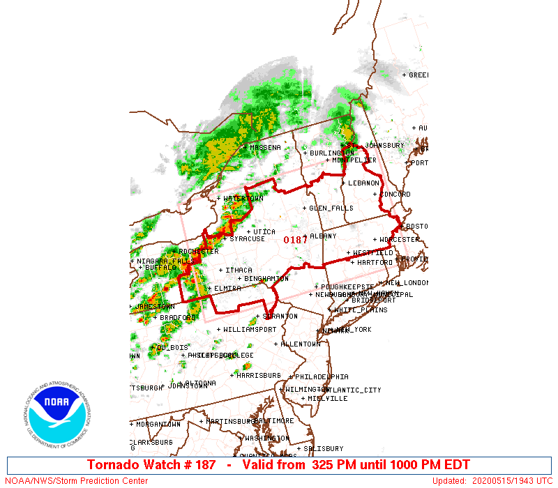
URGENT - IMMEDIATE BROADCAST REQUESTED
Tornado Watch Number 187
NWS Storm Prediction Center Norman OK
325 PM EDT Fri May 15 2020
The NWS Storm Prediction Center has issued a
* Tornado Watch for portions of
western and central Massachusetts
southern New Hampshire
central through eastern New York
northeast Pennsylvania
southern Vermont
* Effective this Friday afternoon and evening from 325 PM until
1000 PM EDT.
* Primary threats include...
A couple tornadoes possible
Widespread damaging wind gusts to 70 mph likely
Scattered large hail events to 1.5 inches in diameter possible
SUMMARY...Storms with a few bowing segments and possible supercell
structures are expected to develop through New York and southern New
England this afternoon and early evening. Damaging wind appears
likely with a couple of tornadoes possible.
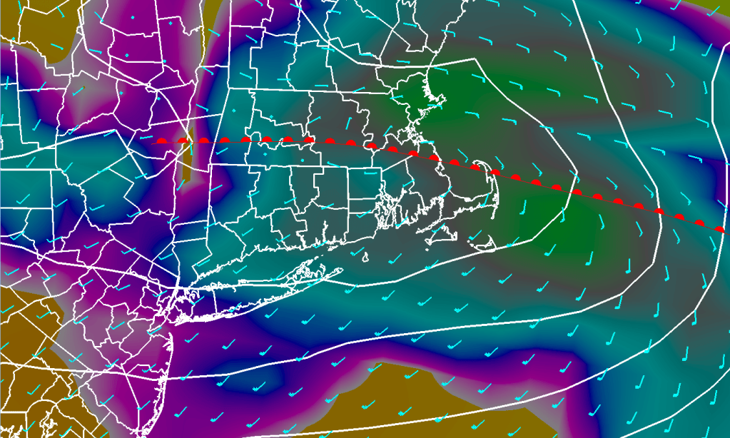
The tornado watch area is approximately along and 90 statute miles
north and south of a line from 45 miles north northwest of Elmira NY
to 30 miles southeast of Concord NH. For a complete depiction of the
watch see the associated watch outline update (WOUS64 KWNS WOU7).
PRECAUTIONARY/PREPAREDNESS ACTIONS...
REMEMBER...A Tornado Watch means conditions are favorable for
tornadoes and severe thunderstorms in and close to the watch
area. Persons in these areas should be on the lookout for
threatening weather conditions and listen for later statements
and possible warnings.
&&
OTHER WATCH INFORMATION...CONTINUE...WW 186...
AVIATION...Tornadoes and a few severe thunderstorms with hail
surface and aloft to 1.5 inches. Extreme turbulence and surface wind
gusts to 60 knots. A few cumulonimbi with maximum tops to 500. Mean
storm motion vector 27035.
...Dial
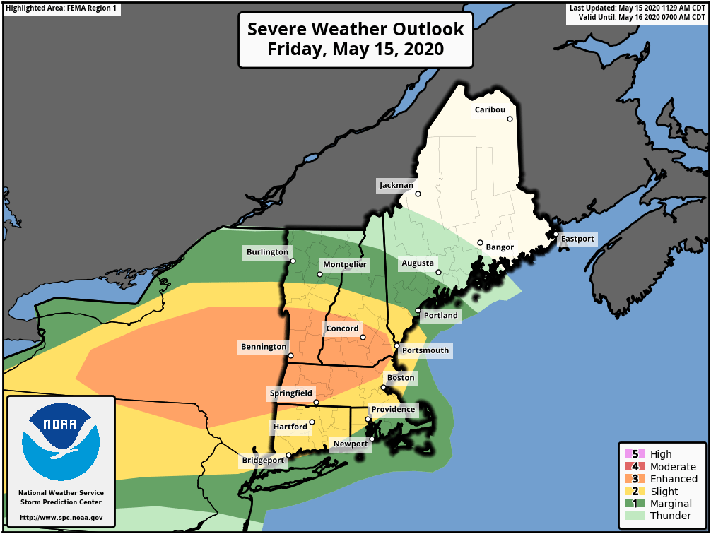
The Storm Prediction Center has placed all but SE CT/Southern RI/and SE MA in either the Slight or Enhanced risk category for severe weather today.
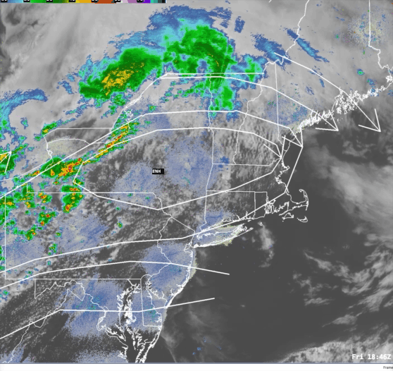
Based on current data thunderstorms are blossoming in western New York state and northern Pennsylvania. This is in advance of a frontal system pushing into the Lower Great Lakes region. In New England we have a very balmy day in progress across much of the state. Temperatures have risen into the middle to upper 70’s everywhere with the exception of Logan Airport, which is currently reporting 68 degrees with a SE wind, and the SE coast of CT, coastal RI, and Cape Cod where temps are in the mid 60’s to around 70 due to the onshore SW wind. The air is also fairly muggy relative to the time of year with dewpoints in the mid 50’s to around 60.
All of these ingredients (warm temps, humid air, and instability) will conspire to hold together the line of thunderstorms running through NY right now. These storms could contain strong damaging winds, hail, frequent lighting and the possibility of a weak tornado, especially in the northern and western sections of MA. I expect these storms to pass through SNE starting around 5-7 pm in NW MA and then advancing into central MA and the Boston area by 7-9 pm. If the storms hold together past the Boston/Worcester area cities like Brockton, Providence and New London may see these storms between 9-11 pm.
An upper level low exiting the northeast this evening is taking the core of this rather coolish air that we’ve had over us over the last few days with it. Replacing it is an area of high pressure building in from the Ohio Valley that will control our weather over the next 24 hour. As this high pressure area slides out over the Atlantic Ocean it will turn our winds into the SW by later on Thursday and this will allow a rather warm flow to set up over the East Coast on Friday.
The forecast for Friday is a little bit tricky as there will be a warm front approaching during the early morning hours which will trigger showers and rain across much of SNE. The tricky part will be figuring if the warm front will make it north of SNE to allow us to break into the warm SW flow or keep us stuck in a considerably cooler E-SE flow Friday afternoon.
8 am Friday Surface Weather Map for SNE
Based on the strength of the high pressure area out over the Atlantic on Friday and a strong west wind aloft I think this ought to help the warm front push through at least SNE. So, I’m going with highs in the low to middle 70’s on Friday with the full realization that the forecast could bust badly. I’m an optimist. :O). Obviously I’ll have to keep an eye on this and potentially make forecast revisions based on tomorrow’s model runs.
By late Friday into Saturday morning we can expect a period of rain as low pressure tracks across central New England. Once this low exits New England on Saturday morning we should dry out and clear out for Saturday. We should have a beautiful day with highs reaching the low 70’s over inland areas but holding in the low to middle 60’s near the east facing coastal areas. The remainder of the weekend should be OK with, once again, warmer temps inland and cooler temperatures along the coastline.
As we get toward Monday/Tuesday we are going to have to keep an eye on two major weather features. One is a storm system that will move through the Upper Great Lakes on Sunday and then into the northeast by Monday. This system may team up with what appears to be a sub tropical low pressure area moving northward parallel to the east coast during Monday. These two features could team up to give us a rather significant rainfall event toward the beginning of next week. The details of this are foggy and rely on a lot of small scale features that the models aren’t great at handling. We will be monitoring this in the coming days.
DETAILED FORECAST:
TONIGHT/OVERNIGHT: Clear winds W 5-10 mph. Low temperature 30-35 in the suburbs, 38-43 near Boston/Providence.
THURSDAY MORNING: Mostly sunny. Winds W 5-10 mph. Temperatures starting off in the 40’s just after sunrise, surging to near 60 by late morning.
THURSDAY AFTERNOON: Increasing cloudiness especially later in the afternoon toward evening. Winds SW turning S toward sunset 10-15 mph G 20-25. High temperature 65-70.
THURSDAY EVENING: Cloudy with rain developing toward midnight, continuing overnight. Winds S-SE overnight 10-15 mph. Low temperature 48-53.
FRIDAY: Mostly cloudy and warm. Risk of showers or thunderstorms especially by late afternoon. Winds S 10-20 with higher gusts. Highs 70-75.
FRIDAY NIGHT: Risk of a shower early in the evening then cloudy. Winds S-SE 10-15 shifting to the NW 5-10 after sunset. Low temperatures 52-57.
SATURDAY: Sunny and warm. Winds NW 12-18 mph turning E toward evening with a few higher gusts. Highs 70-75 inland, 60-65 by the coast.
SATURDAY NIGHT: Clear and cool. E-NE winds 5-10. Lows 43-48
SUNDAY: Mostly to Partly sunny and warm. Highs 55-60 at the coast 60-65 inland.
MONDAY: Rain, possibly heavy at times. Highs 50-55.
..BELOW NORMAL TEMPS TO START THE WEEK, WARMING UP BY THE WEEKEND… …WARMER STILL NEXT WEEK?…
So we managed to squeeze out a few showers today as a storm system passed through northern New England. On the back side of this system we are going to have an anomalously cold system slide over us for a couple of days holding temperatures below normal for this time of year. We should have high temperatures near 70 around now but for Tuesday and Wednesday I think we’re going be lucky to crack 60, especially tomorrow as the core of the cooler air passes through.
Once we’re past Wednesday, we are in store for a major change in the weather pattern that will favor much above average temperatures in the eastern United States. Let’s dig into how that’s going to transpire.
To do this we have to look at the major features that drive how we experience our overall weather pattern here at the surface of the earth. To do that we need to look up. Our weather is largely driven by the high speed rivers of wind that blow at or above 18,000 ft. At that level there are eddies and waves that control the evolution of weather features near the surface. The eddies are often called “shortwaves” and the larger more dominant waves are called “longwaves”.
The distinction between long and short waves is very important. Short waves are small perturbations in the overall flow. Think of a flowing river. The river on a large scale is flowing from left to right (let’s say). As the river flows there will be small swirls that form in the larger flow. These eddies are relatively equivalent to “shortwaves” in the sense that we are talking about. The river itself is the long wave, or the generalized flow from left to right. When you take this and translate it onto a rotating frame (the earth) and then add the uneven heating of the earth between the equator and the poles the river tends to bend and weave. This bending and weaving is the attempt to balance the temperature differences. Those big bending and weaving waves (known formally as Rossby waves) are the “LONGwaves” that we refer to. Basically we are damping out all the shortwaves to reveal the undisturbed river aloft.
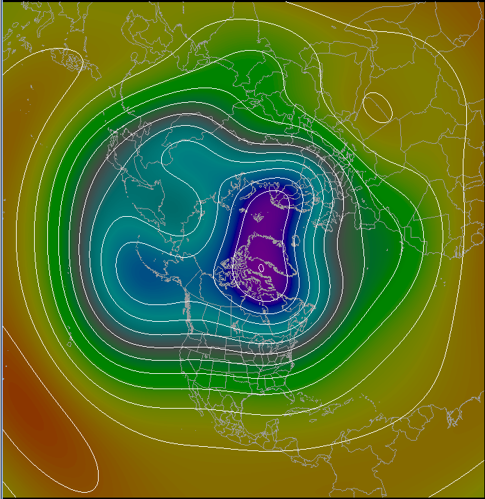
Whew, so what does that mean for the warm up Brian! I’m getting there. :). Lets look at a chart that damps out all the shortwaves:
Looking at the chart above you can see that we have a bunch of these waves. There are a lot fewer of them then you’d normally see on a 500 mb chart. That’s because we took away all the shortwaves.
You can see a large trough over the eastern half of the United States extending from a center over Hudson’s Bay in Canada and a ridge over the west. Troughs in this pattern are caused by the advection of cold air at the lower levels of the atmosphere which lowers the “height” of the atmosphere. When you analyze the data you get a chart that looks a lot like a topographical map where you have peaks and valleys of height.
The valleys in this context are created by cold air “lowering” the height and by warm air “raising” the height of the 500mb surface from the bottom up. These charts are very important to us weather geeks. They tell us, in large scale terms, where the colder and stormier and dry and sunnier weather will be.
This chart, for Tuesday afternoon paints a very cool picture over the northern and eastern portion of the country.
So, after all that, we understand that the big trough over Hudson’s Bay in Canada means colder weather for us. Now, let’s fast forward to Thursday of this week.
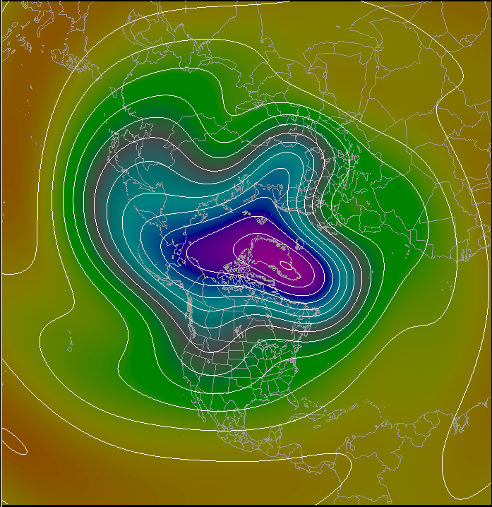
Looking at this chart we’ve got a big change on the way. The large cold trough over Hudson’s bay has diminished and retreated northward into Greenland. This has also allowed the heights to rise across the northern United States. As a result, moderating temperatures are allowed to move into the Great Lakes states and will begin to move into New England as the days go by. Now, let’s go out 10 days from today.
Wow, what a difference 10 days makes. The upper level pattern has completely changed around. The major trough that was keeping us cold has advanced out over the North Atlantic and Greenland. A ridge has replaced the trough in the eastern US and a trough has started digging in over the Western US. This pattern indicates a much warmer picture for the eastern US, with cooler temperatures for the west.
Now it’s important to remember that this is a 10 day forecast which are notoriously dodgy. The advantage, however, of using these 5 wave charts is that we are damping out all of the small features and we are just looking at the longwave pattern at 500 mb. Longwave features tend to be more stable and hold on for periods of a week or two as opposed to the more transient shortwave features. Forecasts of 500 mb height also tend to be a bit more reliable since you don’t need to contend with as much of the physics of the lower part of the atmosphere.
So the upshot of all of this explanation is that we are starting to look at a more spring/summer pattern as opposed to all this chilly stormy weather that we’ve had the last couple of weeks.
DETAILED FORECAST:
TONIGHT/OVERNIGHT: Cloudy with showers possible early. Shower activity ending by midnight. Becoming mostly clear toward sunrise. Winds W-NW 5-15 mph. Low temperature 35-40, near freezing in the Berks.
TUESDAY MORNING: Mostly Sunny and cool. Winds NW 5-10 mph. Temperatures starting in the mid 30’s to around 40 at sunrise, rising to 45-50 by noon.
TUESDAY AFTERNOON: Sunny. Winds W-NW 10-20 mph. High temperature 55-60.
TUESDAY NIGHT: Mostly clear to partly cloudy and cold for this time of year with risk of an overnight shower. Winds NW 10-20 with higher gusts. Low temperature 35-40 in the major cities, 30-35 outside of the major cities.
WEDNESDAY: Mostly Sunny. Winds NW 10-20 G 25-30. High temperature 55-60.
WEDNESDAY NIGHT: Clear winds W 5-10 mph. Low temperature 35-40.
THURSDAY: Mostly sunny. Winds W-NW 10-15 mph G 20. High temperature 65-70.
THURSDAY NIGHT: Increasing clouds, risk of showers overnight. Winds W turn SW then S overnight 10-15 mph. Low temperature 48-53.
FRIDAY: Partly cloudy and warm. Risk of a shower. Highs 65-70.
So, looking at the forecast I issued on Saturday I figured that clouds and rain today would be a safe bet. Yeah, right. The system that will ultimately bring those two things to us today is a little slower getting here than anticipated.
We’ve got clear skies in eastern SNE to start the day but clouds are advancing from the SW and, by this afternoon there will be an increasing risk of showers and thunderstorms.
In fact, the Storm Prediction Center (SPC) has us in their marginal risk area for severe thunderstorms today.
A marginal risk isn’t THAT much of a risk but it’s also not zero risk so as rain and thunderstorms develop today there is a chance that some of these storms could contain hail, high winds, and frequent lightning. Definitely be on the lookout for that today.
A new Southern New England forecast will be released this afternoon.
….A NICE DAY FOR MOM, RAIN (BUT NO SNOW) FOR MONDAY, MODERATION COMING….
Well the little light snow event we had this morning should be the end of it till the next cold season. Tonight will be a little bit chilly as a west wind advects cooler temperatures into SNE. Lows will drop into the lower 30’s outside of Boston and will hover at or below 40 in the city itself. The good news is the air at the surface and aloft should be relatively dry through tomorrow so we should have a fairly nice day for Mother’s Day. Temperatures will be a bit below seasonal norms but the weather should be dry and comfortable.
By Monday another wave of low pressure will will push through New England but will pass north of SNE so this will be an all rain event. Tuesday will feature drier air sunny skies and temperatures around seasonal norms. Then we start moderating on Wednesday and Thursday with partial sunshine throughout and temperatures rising through the 60’s to near 70 by Thursday. Another system may turn us wet by next Friday.
DETAILED FORECAST:
TONIGHT/OVERNIGHT: Partly cloudy to mostly clear. Winds W 10-20 mph near the coast. W 5-10 inland. Low temperatures 30-35 outside the city, near 35-40 near Boston.
SUNDAY: Partly Sunny. Winds W 10-20 mph. High Temperatures 55-60.
MONDAY: Rain developing over CT/SW MA during the early morning, spreading over the rest of SNE before noon. Winds S 10-15 mph High temperatures 60-65.
MONDAY NIGHT: Rain diminishing and ending by midnight. W winds 15-20 mph. Low temperatures 35-40 east of the Berkshires and along the CT/RI coast. 28-33 in the Berkshires into NW CT.
TUESDAY: Becoming mostly sunny. Winds W 10-15. High temperature 58-63.
TUESDAY NIGHT: Partly Cloudy. Risk of a shower southern CT/RI. Winds W 5-10 mph. Low temperatures 35-40 to the coastal plain. 25-30 in the higher elevations.
WEDNESDAY: Partly to mostly sunny. High temperature near 60
….JUST A TEASE…..A LITTLE SNOW TO START THE DAY…..NO ACCUMULATION….
Good morning! I know, many of you are reading this and are saying to yourself “I thought you said it wouldn’t snow!” Well, I did say there wouldn’t be any accumulation and that’s my story still and I’m stickin’ with it. What we are seeing this morning is affectionately called “backlash” which, essentially, is snowfall (or rainfall) that is caused by dynamic forcing on the backside of a developing but exiting cyclone.
This morning we see that “backlash” snow pinwheeling through much of eastern MA. The good news is that this snow will be rather light and should exit in the next couple of hours. In fact, we should see some sunshine by afternoon and temperatures will rise to near 50 today and near 60 tomorrow.
So while it might look like it’s snowing pretty good here and there, it will never add up to anything as there isn’t nearly enough intensity to begin accumulating snow on the ground which is rather warm and quite wet from the rainfall overnight.
So, this morning’s snow is nothing more than a reminder of winter’s past, not a frigid future.
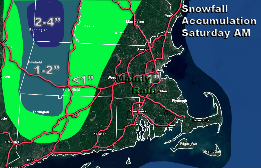
So over the last few days we’ve been tracking a storm that, by all accounts, looks very cold. It caused a little worry that we might have a kind of May 9, 1977 situation on our hands where some interior portions of SNE picked up 6″+ of snow. The good news is, that does not appear to be in the cards. There will be snow in parts of New England but you’re going to need to be way inland and up high for it to stick in any meaningful way.
This snowfall forecast map pretty much tells the story. I’m looking at an inch or two for the Berkshires out in western MA with a snowfall max of near 4″ up by the VT/MA border. The air will not be cold enough overnight tonight for accumulating snow to get too much further east. So, May 9 2020 should be wet and not white for most of us. Thanks 2020 for some small mercy.
….IS IT MAY OR MARCH? HARD TO TELL DURING THE NEXT 48 HOURS….
Looking over the weather maps today it is sometimes hard to tell whether we are heading into the middle to late part of Spring or just ending the Winter. Looking at the overall weather situation right now, things aren’t so bad. We have a mainly westerly flow aloft right now and this allowed today to be a fairly nice day. Upper level low pressure is, however, lurking just north of the Great Lakes over southern Canada. During the next 12-24 hours this upper level low will dig toward the southeast into the Lower Great Lakes region.
At the same time, a disturbance riding along the flow in the Northern Plains will dive through the midwest and then into the Ohio Valley by late Friday. These two features will combine to promote the development of an area of low pressure along the NJ coast by Friday night. In turn, this will begin to spread an area of rainfall first along the southern New England coast on Friday night and then expanding to cover all of Southern New England (SNE) during the wee hours of Saturday morning as the low passes south and southeast of New England. It is also interesting to note that as this area of low pressure intensifies it will turn low level winds into the north and allow colder air to drain into SNE.
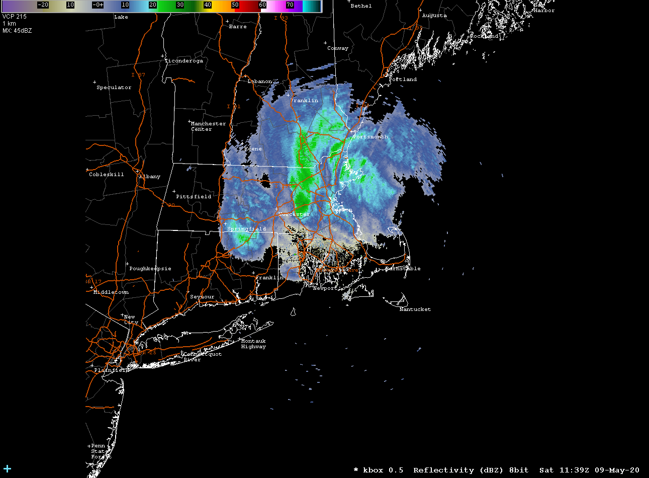
As we look at the upper level feature working its way through the northeast we see a system that looks more like a Feb/Mar system as opposed to early May. In fact, looking at a value we weather nerds use to help determine the rain/snow line called “thickness” I am seeing thickness values (the mathematical difference between the height of the the 500 mb layer minus the height of the 1000 mb layer.) that you typically see with storms that pass through here during the mid to late winter. The rain/snow line is typically found around 540 dm thickness. During the time period that this storm passes south of New England we will have thickness values between 531 dm and 540 dm. If this were January we would be looking at a moderate sized snowstorm at least. Given that it is May and the sun angle is high severely complicates the forecast even in light of the important meteorological indicators suggesting that snow may occur. The higher sun angle will heat the air sufficiently on Friday that the storm will have a warm pre-storm environment to contend with.
As the storm intensifies offshore it will tend to draw colder air in. The vertical motion generated by the intensifying storm can also dynamically cool the atmosphere and help drop the temperatures toward freezing at all levels. What all this means is, we could see snowfall somewhere in New England Friday Night into early Saturday morning. Where that rain/snow line sets up is the big question. My feeling is that within the immediate Boston area, let’s say inside of 128, temperatures will manage to remain above freezing and substantial accumulating snow will not be likely. In the SW suburbs of Boston, into the RI hills and then into Worcester county there could be some mixing of the rain with snow as colder air leaks into those regions. In Western MA and northern Worcester county I feel there could be accumulating snow due to the fact that these are higher elevation areas which should have temperatures low enough to allow for a change over for a period of time during the pre-dawn hours of Saturday. Much of this will also depend on the exact intensity and track of the low pressure area. If the storm becomes stronger than expected the dynamic cooling effects could allow accumulating snow to come further toward the east and south. Same if the track of the storm is further to the SE.
I am reluctant to issue any snowfall accumulations just yet. I want to see another model run before I do that. Again, any accumulations will be to the north and west unless the storm does something unexpected.
Once this storm passes on by temperatures will be below normal into next week as we are stuck in a cool rut. I think toward the end of next week we should start breaking that pattern and warm up a bit. Patience…..spring is coming.
DETAILED FORECAST:
TONIGHT/OVERNIGHT: Cloudy risk of showers then clearing out overnight Winds becoming SSW and then shifting into the W overnight 10-15 mph. Low temperatures 30-35 western MA and CT. 35-40 E MA and RI. 40-45 over the Cape and Islands.
FRIDAY: Mostly sunny through the morning hours. Clouds increasing by afternoon across CT/RI and SE Mass and by evening through the rest of southern New England. Winds WSW 10-20 mph with higher gusts. Highs 55-60.
FRIDAY NIGHT:Cloudy with rain developing over the south coast of New England from the NY/CT border to Chatham, MA during the early evening. Rain spreading northward into the Boston area after midnight. Rain possibly mixing with or changing to snow especially west and north of 495/90. Winds NE to N 15-25 mph with higher gusts. Highest winds and gusts at the coast. Low temperatures near 40 in the city. 32-37 north and west.
SATURDAY: Snow/Rain tapering off and ending by afternoon. Winds NW 15-20 with higher gusts. High temperatures 45-52.
SATURDAY NIGHT: Clearing skies especially after midnight. Winds W 10-20 mph. Low temperatures 30-35 outside the city, near 40 in Boston.
SUNDAY: Partly Sunny. Winds W 10-15 mph. High Temperatures 60-65.
Development of Afternoon Overcast Over New England on Monday
After a beautiful sparkling start to the day today, as forecast, we got stuck with cloudy overcast skies by afternoon. This was due to the movement of an upper level disturbance over New England. Combine that with unstable air and you’ve got clouds and even a few showers. As the sun goes down in the next 2 hours or so the overcast will begin to diminish and ultimately clear out, especially across southern New England. For northern New England the clouds will hang in a little longer.
By tomorrow the cycle will start over again but mainly in northern New England. Southern New England should be mostly sunny and temperatures will rise to or slightly above 60 degrees.
Wednesday should be a pleasant day as well but clouds will be on the increase starting in SW sections in the morning advancing to the NH/VT/MA border by evening.
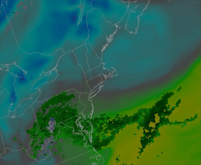
Predicted Northeast Radar Composite 2pm Wednesday through 11pm Thursday
The next weather maker will be a coastal storm that will make its way across the waters SE of Cape Cod on Thursday morning. Looking it over this morning it seemed to me that there could be the potential for some frozen precipitation during Thursday but at this point I am reasonably sure that won’t happen. Looking at the model soundings during the time that the storm will pass SE of New England the air column throughout Southern New England (where most of the precipitation will fall) will be too warm especially in the lower 2000 feet of the atmosphere. In areas where we get some rainfall intensity there could be some mixing in of ice pellets but I think for the most part we are looking at some rain and not much beyond that.
Generally, beyond Thursday, it looks like weather systems riding along the jet stream will be on the weaker side and I’m not expecting any weather extremes.
DETAILED FORECAST:
THIS EVENING/OVERNIGHT: Decreasing clouds with skies clearing overnight in Southern and central New England. Mostly cloudy across NH, VT and ME. Rain or snow showers across northern sections. Winds NW 5-15 mph with gusts 20-30 mph. Low temperatures 35-40 most inland areas. 30-35 across far northern New England, 40-43 in the coastal cities.
TUESDAY MORNING: Mostly Sunny across southern New England, mostly cloudy everywhere else. Winds NW 10-20 mph with some higher gusts. Temperatures starting off in the low to mid 30’s at sunrise, rising through the middle to upper 40’s to near 50 across SE New England by late morning. Temps will hang back in the mid 30’s across northwestern parts of New England.
TUESDAY AFTERNOON: Continued mostly sunny across southern New England. Partly to mostly cloudy across central and northern NH/VT. Overcast across much of Maine. Rain/Snow showers possible across northern Maine. Winds NW 10-15 gusting 20-30 across the higher elevations of NH and ME. Highs near 60 in southern New England, upper 40’s to low 50’s through central sections. Low to middle 40’s through northern VT/NH. Around 50 for southern ME. 45-50 through central ME, near 40 through northern and western ME near the Canadian border.
TUESDAY NIGHT: Mostly clear to partly cloudy south to north. Winds light and variable just about everywhere. Low temperatures 25-30 across northern New England and the northern 2/3rds of Maine. 30-35 through much of VT/NH and western MA. 35-40 for the coastal plain.
WEDNESDAY: Sunny skies through the morning hours. Increasing clouds across CT/RI by late morning, clouds moving NE into the Boston area by late afternoon. Remaining partly to mostly sunny across NH/VT/ME. Winds E 10-15 mph in southern New England, light and variable, central and northern sections. High temperatures 55-60 along coastal locations, 60-65 away from the coast.
WEDNESDAY NIGHT: Overcast throughout all of southern New England. Mostly cloudy across central sections, clear in Maine north and west of Portland. Rain developing across CT/RI and SE MA. N-NE 10-15 mph except along the coast where winds should be 15-25 mph. Low temperatures 35-40.
THURSDAY: Cloudy with rain likely. Winds NNW 10-20 mph. High temperatures 50-55
FRIDAY: Partly Sunny. Highs in the mid 40’s north to the mid and upper 50’s south.