Severe Weather Outbreak Potential for Southern United States
Issued: April 12, 2020 @ 5:00pm
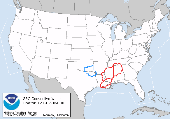
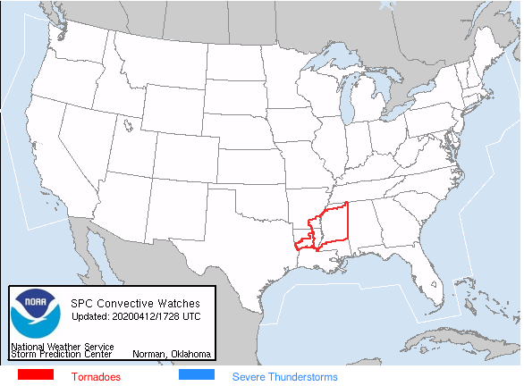
The national weather service issued Tornado Watch 109 at 420pm EDT for much of central and northern Alabama as the severe weather outbreak continues this afternoon across the southern US.
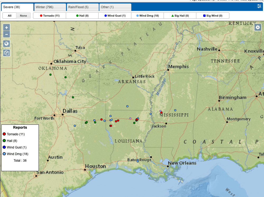
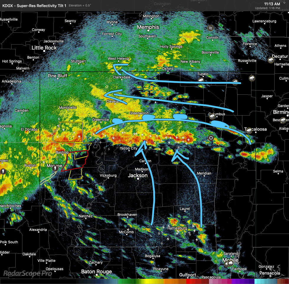
While official tornado reports have been relatively sparse at this time there are several severe thunderstorms with rotation that have developed across the south.
One that I’ve seen in particular is a large rotating thunderstorm just west of Tuscaloosa, AL. This storm currently has a tornado warning on it as it advances to the east-northeast into the Tuscaloosa metro area.
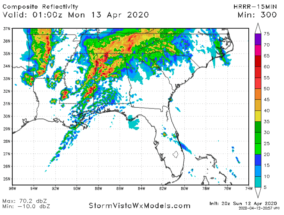
High Res computer models continue to project that thunderstorms will continue to blossom across the south for the next several hours. The severe thunderstorm/tornado threat will move eastward into Alabama by this evening.
Severe Weather Outbreak Potential for Southern United States
Issued April 12 2020 – 1:00 PM
FORECAST DISCUSSION:
There continues to be a very real possibility of a serious severe weather outbreak across the southern United States this afternoon.
Presently there is a complex of severe thunderstorms moving through north central Louisiana and tornadoes have been reported east of Shreveport, LA. This complex of thunderstorms will continue pressing toward the northeast into SW AR and western MS. There is also a line of storms, with radar indicated rotation, moving through north central MS. These are along and just north of a warm frontal boundary. The air mass south of this warm frontal boundary is warm and very humid. Dew points are in the upper 60’s and lower 70’s throughout this area and will provide fuel for the continuing development of thunderstorms throughout the afternoon.
Later this afternoon a new line of thunderstorms looks likely to form during the time of maximum heating of the atmosphere in the warm and humid air mass south of the warm front.
This line of storms will move through Mississippi and then into north central Arkansas by late evening. There will be the substantial risk of strong winds, hail and tornado activity. Given the environment that these storms have to work with the potential for widespread tornado activity is very high.
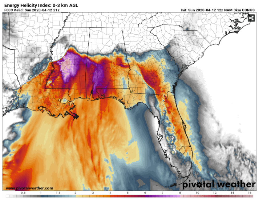
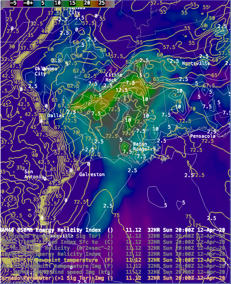
Energy-Helicity Index forecast for 5pm EDT Sunday April 12, 2020
As we discussed yesterday, one measure of determining the likelihood of tornado activity is the Energy-Helicity index. Values of 1 or more indicate a strong potential for tornadoes. Some values in the chart above are in excess of 7 which indicates a strong potential for very large severe tornado development. Residents of LA, MS, AR should be prepared for the possibility of life threatening weather.
This situation has prompted the Storm Prediction Center to issue a Particularly Dangerous Situation alert along with the Tornado Watches which have been issued this afternoon.
Further information about this Tornado Watch/PDS can been obtained at:
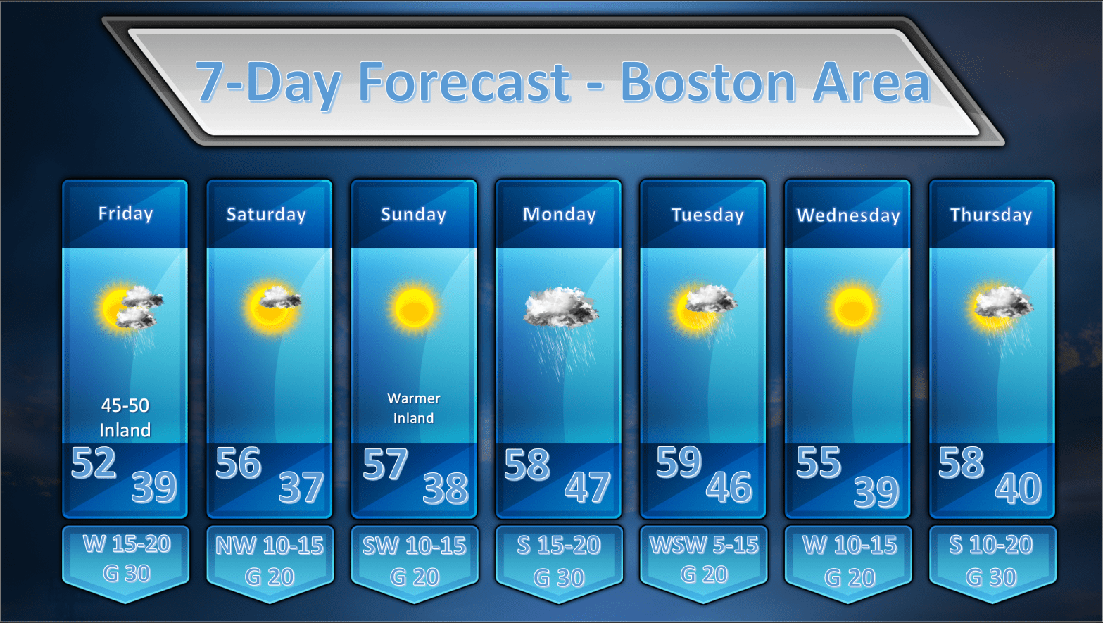
This will be a short discussion this evening as there really aren’t any major changes to the forecast. There are, however, some fairly important notes for Monday.
The map below is a map of the watches and warnings issued for Southern New England. The brown outlines which are shown all throughout MA/RI/CT and SE NY are High Wind Watches issued by the National Weather Service which have been hoisted for Monday morning through Monday evening. This high wind watch is being issued as a result of the storm that will impact our area on Monday with a rather heavy slug of rainfall. We are still anticipating at least 1.00″ of rainfall across much of eastern MA from around sunrise on Monday through sunset.
Winds will be rather brisk out of the south across much of SNE with sustained winds 20-35 mph. Wind gusts are forecast to be upwards of 60+ mph in the Boston area and could possibly reach or exceed hurricane force (74 mph) on the Cape and Islands.
Forecast Wind Gusts @ 5pm April 13th (wind speeds are in knots. 1 knot = 1.15 mph)
Winds will be rather strong on Monday afternoon so travel is not recommended if you can help it. High profile vehicles will be particularly vulnerable to the winds during the time of highest gusts. The strongest winds will move into the Boston area during the late morning and continue into the early evening hours before diminishing overnight.
As for the remainder of next week….the weather should be relatively calm and seasonable with temperatures near or just a wee bit above normal.
Severe Weather Outbreak Potential for Southern United States
Issued April 10 2020 – 3:30 PM
FORECAST DISCUSSION:
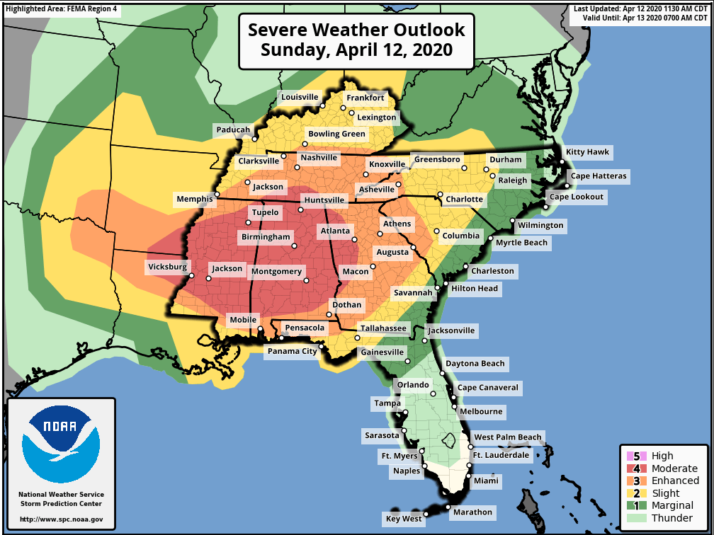
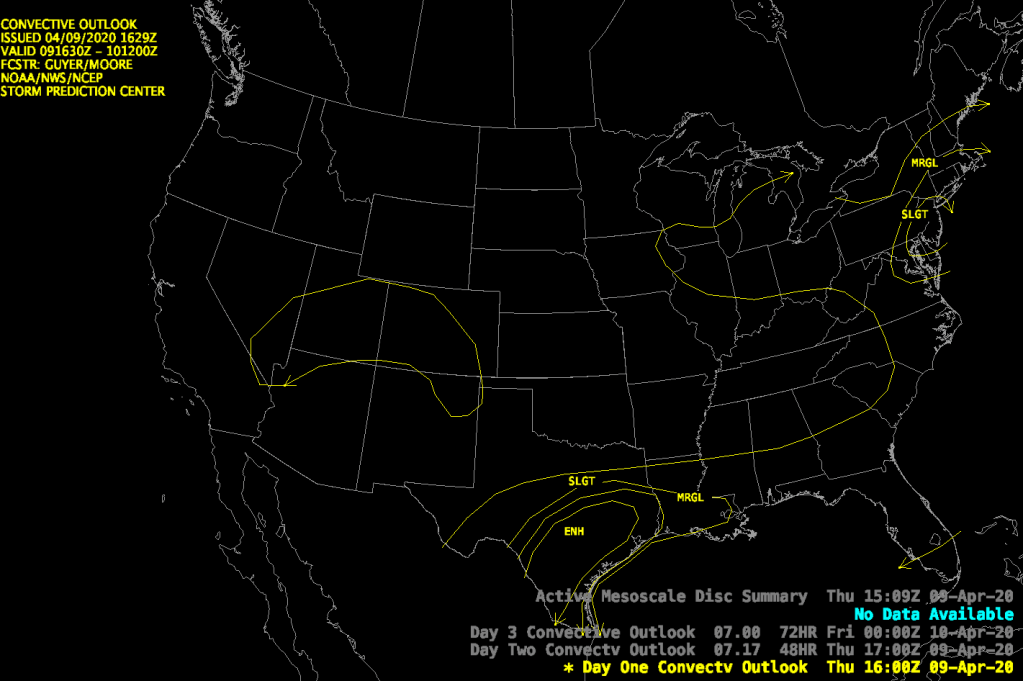
A fairly significant severe weather outbreak looks to be on tap for Louisiana, Arkansas, Tennessee, Mississippi, Alabama and Georgia during Easter Sunday. The Storm Prediction Center has much of the Southern united states under an enhanced to moderate risk of severe thunderstorms as shown above. An explanation of these risk categories can be found below:
The set up for tomorrow is particularly potent as the ingredients for severe weather come together over the southern United States:
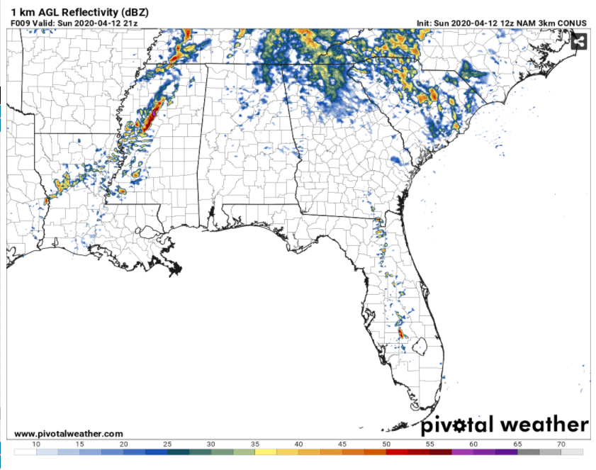
The charts below demonstrate those ingredients in action. These charts are looping from 8am Sunday through 8pm Sunday.
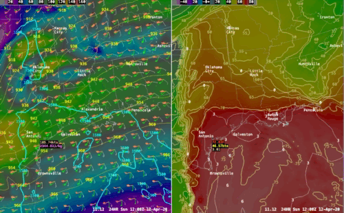
MOISTURE: The first ingredient is copious moisture surging out of the Gulf of Mexico into much of the Southern United States. The chart on the right shows this with 60+ degree dew points moving north throughout the day on Sunday. This moisture will provide the fuel for thunderstorm development during the day.
UPPER LEVEL JET DYNAMICS: Secondly we have a very strong jet max punching into LA, MS, AR, TN with the favored left front quadrant (where all the upper level divergence is) making its way into LA/MS/AR. The strong upper level divergence will cause strong surface convergence (create a “vacuum” at the top of the atmosphere, air rushes in and up to fill it) and vertical ascent which will aid the formation of thunderstorms.
STRONG DIRECTIONAL AND VERTICAL WIND SHEAR: If you look closely at the chart on the left the wind direction and speed is indicated by the barbs on the map. I have put the wind from three different levels on the chart:
What this shows you are winds turning strongly with height. If you go from the top of the atmosphere down toward the surface these winds are turning cyclonically which is the twisting motion you want for the development of tornadoes. This is directional shear.
In addition the winds at 300 and 700 mb are way stronger than the near surface winds. If you were to put a paddle wheel (that’s a BIG paddle wheel) between the surface level and the higher level winds the paddle wheel would start rotating being pushed by the stronger winds at the top. This is vertical wind shear or “speed shear”.
So you have 2 types of twisting motion in the atmosphere, once created by directional differences in the wind and the other created by speed differences. These conspire to aid in the development of rotating thunderstorms or “supercells” which can spawn tornadoes.
INSTABILITY: With the approach of the upper level trough you are also quickly cooling the upper atmosphere. This condition creates an unstable atmosphere which allows parcels of air to begin to rise from the warmer earth’s surface into the cooler upper atmosphere. The greater the temperature difference between the surface and the upper atmosphere the more buoyant the air and the more buoyant the air is the easier it is to form thunderstorms. We measure the energy available to spawn and maintain convection by using a value called Convective Available Potential Energy or CAPE. CAPE is sum of the areas within a curve on a vertical atmospheric sounding where the lifted parcel temperature remains warmer than its environmental temperature. The value is expressed in Joules/kg. The longer an air parcel is warmer than its environment temperature the longer it will rise up into the atmosphere. So, larger values of CAPE essentially translate into a parcel of air that is buoyant high into the atmosphere. The chart on the left shows values of CAPE with the cyan colored lines. CAPE values tomorrow across the south will be in excess of 2000 j/kg and there will be some areas that could see CAPE values as high as 4000 j/kg! CAPE values of greater than. 2500 j/kg are associated with very unstable conditions with the strong potential for severe thunderstorms and tornadoes.
Combining some of these ingredients we can create further diagnostic indices that allow us to further evaluate the risk of where tornadic activity may occur. One of the more reliable indicators is the Energy-Helicity Index (EHI). EHI values of over 2.5 usually indicate a high likelihood for tornadic storms. EHI values in excess of 4.0 usually indicate the potential for violent tornadoes to form.
The chart above shows the values of EHI (white lines) across the deep south at 4pm EDT tomorrow. The dew point temperatures (yellowish lines) are also shown here and another parameter called the Significant Tornado Parameter (STP – indicated by shaded areas). The EHI and STP values paint a fairly serious situation for an area from northern Louisiana, across southern Arkansas into western Mississippi around 4pm EDT where EHI values will be at 5 or better. STP values of greater than 2 usually indicate the risk of significant tornado activity. The values in yellow and orange above are well in excess of that threshold.
So, it appears that the greatest risk of widespread tornado activity will start across the states of LA/western MS/southern AR during the early – mid afternoon hours tomorrow and then migrate into MS and AL during the early evening hours. The tornado risk should diminish quickly after about 9-10 pm EDT as the atmosphere stabilizes and the best dynamics push off toward the northeast.
REMAINDER OF FRIDAY: So the weather worked out pretty much as expected today with a sunny start then clouds and showers. In fact as of this writing showers are still pinwheeling through SNE and will continue to do so for another hour or perhaps two. These showers are forming in response to a large upper level low over our area right now. Spokes of upper level energy rotating around the low tend to spark a shower or two here and there. A line of showers that moved from southern NH through MA and exited just south of Cape Cod had the most potent of the showers. There was even a little frozen precipitation (graupel) mixed in with the strongest of these showers.
All this activity will come to an end as the atmosphere stabilizes as the sun goes down and the upper level low pulls away to our north.
SATURDAY: The upper low is going to lift out fairly quickly and the mid levels of the atmosphere are going to dry out fairly well. There should be much more sunshine tomorrow with some fair weather clouds forming in the afternoon. Since there will be less mid level moisture available I don’t think we will see much in the way of shower activity if anything at all. At this point, I am still leaving showers out of tomorrow’s forecast.
SUNDAY: Sunday looks like a nice day with a mid level high pressure ridge building over the top of us through the morning hours. The models are indicating quite a bit of moisture streaking in at mid-levels so some cloudiness is likely to develop on Sunday. I think they will hold off until early afternoon as we remain east of the 700 mb ridge axis until about then. Once the ridge axis slides by I think middle clouds will build throughout New England say around 1-2pm as the warm advection associated with an approaching warm front starts being felt at that level of the atmosphere. Lower cloudiness will work in later in the afternoon as the warm frontal boundary advances. I don’t see much in the way rainfall on Sunday however. I expect we will stay dry.
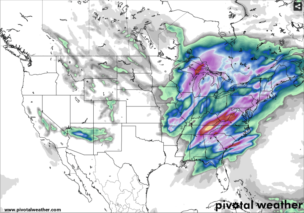
GFS 24 h Precipitation Forecast 8pm Sunday – 8pm Monday
ECMWF 24 h Precipitation Forecast 8pm Sunday – 8pm Monday
MONDAY: Low pressure which will cause a fairly significant severe weather outbreak down in the south on Sunday will then move toward our area on Monday with the promise of some heavy rainfall. Precipitable water values as high as 1.4″ will transit across New England on Monday along with a strongly diffluent 500 mb flow. This should allow for periods of heavy precipitation throughout New England. Rainfall amounts of .80 – 1.20″ will be possible generally across southern New England but I wouldn’t be surprised to see locally higher amounts in heavier downpours. The model output above shows the GFS and Euro 24h total precipitation amounts. The two models are in fairly good agreement so it looks pretty certain that we will see a pretty good rain event. There is also some indication of elevated instability associated with this system which could spawn the chance of a few rumbles of thunder but that appears to me to be a low risk situation at this time.
TUESDAY: Monday’s storm rolls up into James Bay and drier air works into New England allowing for fairly abundant sunshine for most of the day. It had looked like there might be a chance of showers on Tuesday but that risk seems to have fallen to the wayside.
WEDNESDAY: Nothing remarkable about Wednesday’s weather. Weak low pressure will be tracking far to our south but it may throw some clouds into southern RI, CT and the Cape. For the rest of us there will be abundant sunshine and seasonable temperatures.
THURSDAY: A weak area of low pressure looks like it may generate clouds and a few showers during Thursday. A few hundredths of an inch of precipitation may be possible with this system as it passes through.
FRIDAY: On balance friday should be an ok day for much of New England but a weak upper level disturbance riding along in the flow may generate some showery rainfall, especially late in the day to the south of Boston. A couple of tenths of an inch may possible in E CT, RI and SE MA late in the day.
REMAINDER OF THURSDAY: The forecast is working out quite well today. While there doesn’t appear to have been any thunderstorm activity north of the MA pike and east of I-91, a few thunderstorms did move through far western MA earlier today and several thunderstorms, some requiring severe thunderstorm warnings, did move through Long Island sound, coastal CT, coastal RI and south coastal MA. These storms more or less developed right in the area of most instability right on schedule. The last of the severe thunderstorm warnings will expire out on Cape Cod @ 5:30pm.
Strong and gusty winds, associated with the frontal passage, are on the way into our area. Wind gusts of 25-35 mph are showing up in eastern NY, western MA and CT. These wind gusts will progress to the east along with the clearing. It should be a rather breezy and gusty night tonight as the front pulls away. Gusts upward of 25-35 mph will be possible in metro Boston and possibly upwards of 35-45 mph on the Cape and Islands.
FRIDAY: Not much change to the Friday forecast. Yesterday’s discussion follows:
The front/storm that passes through Thursday will blow up in to a pretty good sized storm to our northeast. This should allow the pressure gradient to remain pretty tight which should lead to another breezy and gusty day on Friday with westerly winds 15-25 mph sustained along with gusts up to 35 mph strongest along with south coast, Cape and Islands. It will be unsettled as an upper low remains close to New England. Clouds and the risk of a shower will be around for the balance of the day. I think it will be a bit on the cool side as well, and I am going to undercut guidance by a bit on Friday. I’m going to go with highs predominantly in the lower 50’s for much of the area.
SATURDAY: Saturday looks less unsettled to me. It looks like the upper low is going to lift out fairly quickly and the mid levels of the atmosphere are going to dry out fairly well. I am removing any mention of shower activity from Saturday’s forecast. If any showers are going to develop they would be over northern New England. Expect a mostly sunny day with a few afternoon fair weather clouds.
SUNDAY: Sunday looks like a nice days with a mid level high pressure ridge building over the top of us. The models are indicating quite a bit of moisture streaking in at mid-levels so I’m not entirely convinced that it’s going to be a perfectly clear day like the models are suggesting but that’s what I’m going with for now. It should be pretty mild as well with temperatures at the coast in the mid-upper 50’s. Inland, temperatures should reach the low to mid 60’s. Winds will be fresh out of the SW with occasional gusts.
MONDAY: The models continue to advertise a fairly vigorous low pressure area rolling up into the Great Lakes on Monday and this should still lead to a burst of rainfall moving up into New England. The models have become less aggressive about developing a secondary coastal low pressure area and this has had the effect of focusing the heavier rainfall back toward the western part of New England. PWAT values are still above 1.00″ so there is plenty of moisture to wring out of the atmosphere. Eastern portions of MA/RI/CT could get 0.50″ – 1.00″ of rain while western New England could see in excess of 1.00″. There is decent agreement between the ECMWF and GFS on this idea so I am going to buy into it. I expect this is going to shift around a little more before we get to Monday.
TUESDAY: No change to the previous forecast here. Monday’s storm rolls up into James Bay and drier air briefly works into New England allowing for morning and early afternoon sunshine. It appears that a surface trough of low pressure is going to be rotating around the storm and it looks like this is going to provide the focus for some clouds and perhaps a few showers late on Tuesday.
WEDNESDAY: Nothing remarkable about Wednesday’s weather. High pressure building in from the west will clear us out and it should be a rather pleasant day with a mix of sun and clouds with highs in the mid 50’s.
THURSDAY: A weak trough of low pressure looks like it may generate a few showers over the western part of MA/SE VT/West NH/NW CT during the late morning. Otherwise nothing very interesting happening on Thursday the 16th.
The Storm Prediction Center has issued its 12:30 pm update and they have included Southern New England in the marginal risk area for severe weather. We are seeing some thunderstorm activity, indicated by the lightning detection network, embedded in the larger area of showers that are sliding through our area as indicated earlier. Most of the thunderstorm activity is located in SE NY and eastern PA but there are also some isolated lightning strikes in Long Island sound and southern RI. This is largely confirming my earlier update but, given the SPC’s more aggressive outlook, there could be stronger thunderstorms further north into MA south of the Mass Pike. I still believe that the best chance for thunderstorms remains across southern RI/CT but be on the lookout along and south of a line from Quincy, MA through Worcester, MA this afternoon.
Rainfall has become widespread across much of southern and central New England in response to a complex low pressure system moving through western New York state this morning. A line of heavy showers associated with the cold front is moving through central NY at this hour. A surface trough of low pressure along with a moist SE flow off the Atlantic is generating more showery rain, drizzle and lots of cloudiness over New England. As we move into the afternoon hours the line of heavy showers will progress through New England from west to east. These heavier showers may generate a flash of lighting and a rumble of thunder with the best chances of that happening where MUCAPE values are able to rise above 100 J/kg. I think southern CT and southern RI will be the locations best suited for this to happen. The air mass will be too stable north of there to generate much convective activity at all. The heavier showers will start to impact the western part of the state around 1pm and the Boston area should feel the impacts from the passage of the cold front between 3-4pm.
THIS AFTEROON/TONIGHT: After the passage of the weak wave of low pressure that brought us fairly gloomy weather we are still seeing clouds around this afternoon as advertised. Also as advertised yesterday we are seeing some drying out of the cloud deck and it looks like sunshine is breaking out north and west of the 128 belt. I expect that this clearing trend will continue through the rest of the afternoon as drier air works its way in at mid levels from the southwest and a 700 mb ridge slowly builds in. During the overnight hours I expect that skies will become mostly clear.
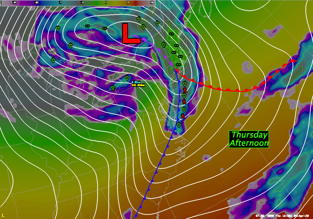
THURSDAY: Not much change to Thursday’s forecast thinking as the fast moving weather pattern will bring our next weathermaker along. A strong cold front will be sweeping through western New York on Thursday morning and that front will reach the vicinity of the Boston area by the mid – late afternoon hours. There could be a period of heavy showers and/or a period of steady rain as the front moves through. It looks like the heaviest activity would move into eastern MA between 1pm – 5pm. The indicators for any thunderstorm activity with this frontal passage remain very iffy but given the strength of the upper level support pushing into E MA, RI and Srn NH I am thinking that there will probably be a flash or two of lightning or a rumble of thunder somewhere. I think the best bet for that will be along the S. CT or S. RI coasts where 200-300 J/kg of MUCAPE along with 6-7 deg C/km mid level lapse rates sneak in between 1-4pm. This is supported by the high res models where even higher MUCAPE is shown. There will be strong and gusty winds associated with the frontal passage as well. Gusts upward of 30-40 mph will be possible in metro Boston and possibly upwards of 45-50 mph on the Cape and Islands.
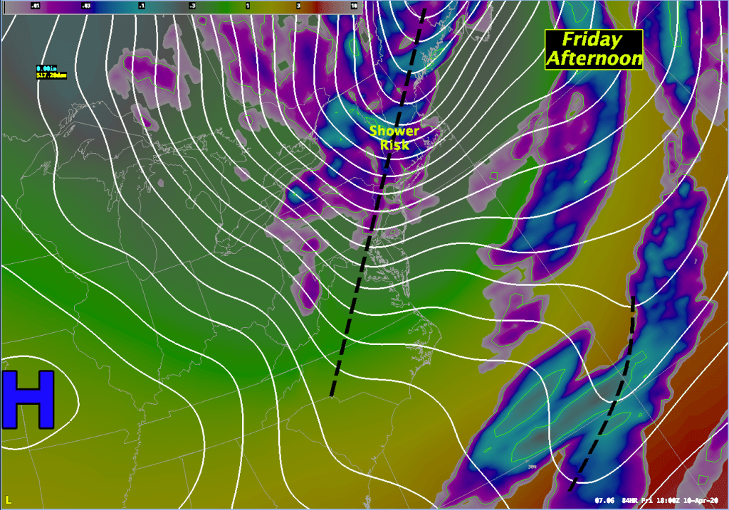
FRIDAY: The front/storm that passes through Thursday will blow up in to a pretty good sized storm to our northeast. This should allow the pressure gradient to remain pretty tight which should lead to another breezy and gusty day on Friday with westerly winds 15-25 mph sustained along with gusts up to 35 mph strongest along with south coast, Cape and Islands. It will be unsettled as an upper low remains close to New England. Clouds and the risk of a shower will be around for the balance of the day. I think it will be a bit on the cool side as well, and I am going to undercut guidance by a bit on Friday. I’m going to go with highs predominantly in the lower 50’s for much of the area.
SATURDAY: Saturday still looks a bit unsettled but a little less so as the upper low lifts a bit to the north. Northwesterly winds will continue to be fresh around 10-15 mph with some gusts to 20 but it shouldn’t be as windy as Thursday or Friday were. The upper low will still b
SUNDAY: The upper low lifts away completely by Sunday and is replaced by an upper level ridge of high pressure which should completely dry out the atmosphere. It looks like a mostly sunny and mild morning. The models are bringing in some clouds by late afternoon and skies will become overcast by Sunday evening. This is in advance of a storm developing over the midwest during the day on Sunday. This system will figure into our forecast for monday.
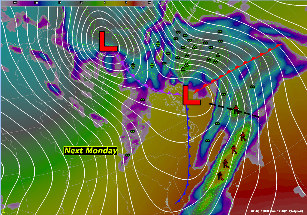
MONDAY: After midnight Sunday rainfall should begin to move into New England from the storm mentioned above. This system will be moving through the Ohio River Valley/Great Lakes by this time along with a developing secondary area of low pressure near Cape Hatteras, NC. Precipitable water values of .90 – 1.00″ will be punching into southern New England during the early morning hours of Monday and these high values will persist throughout the day allowing for a pretty good soaking for much of New England. It looks like about 1.00 – 1.50″ of rain will fall during the early morning through the early afternoon hours of Monday. The timing of this is still in flux so we will update this as the situation develops.
TUESDAY: Monday’s storm rolls up into James Bay and drier air briefly works into New England allowing for morning and early afternoon sunshine. It appears that a surface trough of low pressure is going to be rotating around the storm and it looks like this is going to provide the focus for some clouds and perhaps a few showers late on Tuesday.
WEDNESDAY: Nothing remarkable about Wednesday’s weather. High pressure building in from the west will clear us out and it should be a rather pleasant day with highs in the mid 50’s.
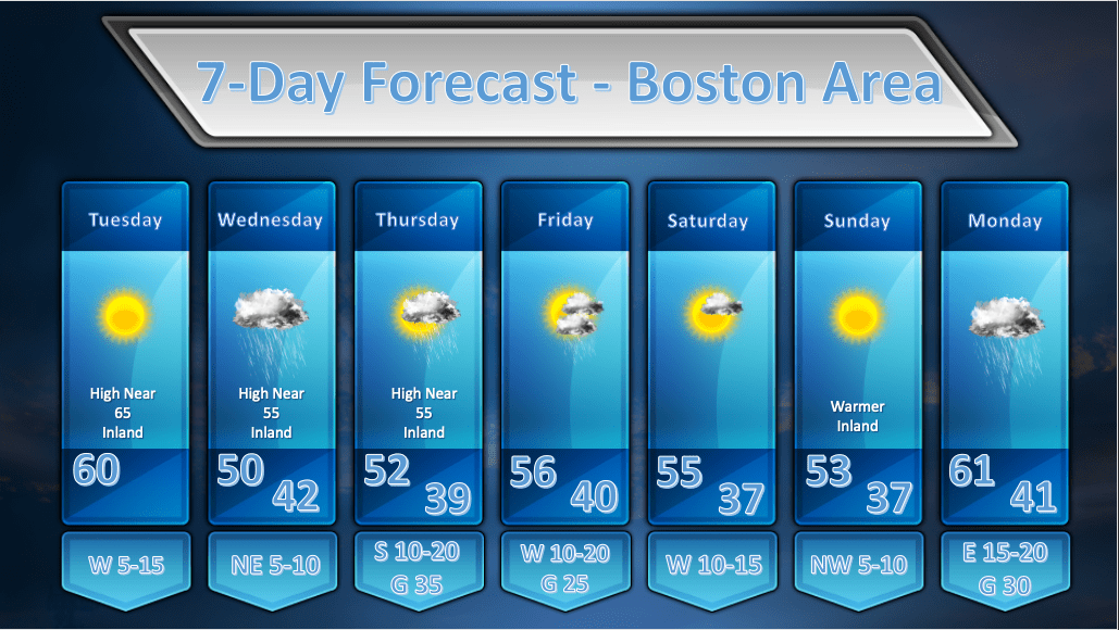
TODAY: A beautiful day. Clear skies with high temperatures that should get into the 60-65 degree range with light winds.
WEDNESDAY: Clouds will be on the increase during the overnight hours Tue into Wed and light rain should break out primarily after 2am. A wave of low pressure will pass south of Long Island during the day and this should generate some light rain/drizzle for the better part of the day. The models do indicate some mid-level dry air trying to work in during the late afternoon hours and its possible that we will see some breaks in the overcast late in the day toward sunset.
THURSDAY: The fast moving weather pattern will bring our next weather maker along for Thursday. A strong cold front will be sweeping through western New York on Thursday morning and that front will reach the vicinity of the Boston area by the late afternoon hours. There could be a period of heavy showers and/or a period of steady rain as the front moves through. The timing on this looks to be between noon and 4pm. If it were warmer and a bit more humid I would probably throw in the chance of a rumble of thunder as the front pushes through but I’m leaving it out now. Don’t be surprised if it happens! There will be strong and gusty winds associated with this front’s approach. Gusts upward of 30 mph will be possible in metro Boston and possibly upwards of 50 mph on the Cape and Islands.
FRIDAY: The front/storm that passes through Thursday will blow up in to a pretty good sized storm to our northeast. This should allow the pressure gradient to remain pretty tight which should lead to another breezy and gusty day on Friday but not quite as windy as Thursday. The upper level low associated with this storm will be parked over Atlantic Canada and spokes of upper level energy will rotate around this low and bring the risk of showers along with them.
SATURDAY: Saturday still looks a bit unsettled but a little less so as the upper low lifts a bit to the north. We will still see spokes of energy whipping around so I still envision some clouds being around with a risk of showers though that risk should be smaller.
SUNDAY: The upper low lifts away completely by Sunday and is replaced by an upper level ridge of high pressure which should completely dry out the atmosphere. It looks like a mostly sunny and mild day. The models are suggesting that some high clouds may slide in during the day as another storm approaches from the SW.
MONDAY: A rapidly deepening low pressure area will move through the Ohio River Valley into the Great Lakes on Monday. A secondary area of low pressure will develop just off the Delaware coast on Monday morning and this should enhance the rainfall potential from this system. We’re still a little too far away from this event to say for sure how much rainfall we will see, but right now, it does look like it could be a soaker.