Issued April 3 2020 – 1:30 pm
Rain and wind dominate today’s forecast as the ocean storm we’ve been tracking for the last couple of days rages on out over the ocean. The storm is making its closest pass to New England as of this writing so we are experiencing the maximum impacts from this system.
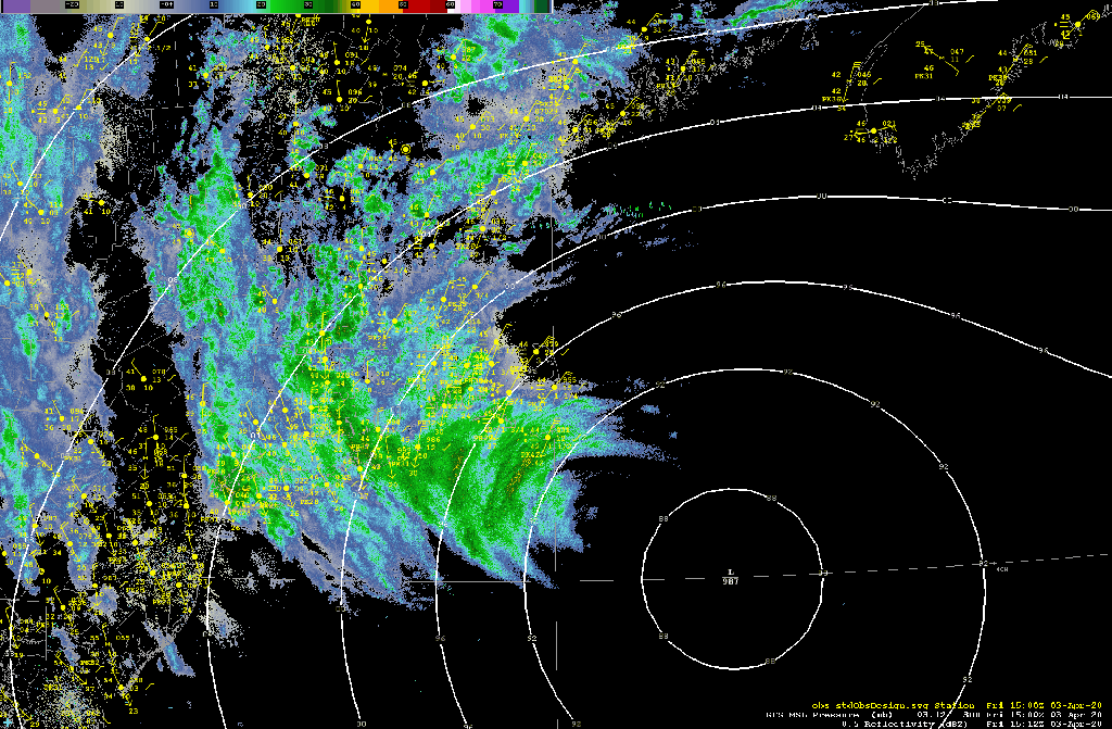
The heaviest of the rain from this system came through last night but the wind is still very much a factor along the coast. Reported wind gusts from this storm:
LOCATION             MAX WIND     TIME/DATE   COMMENTS
                        GUST            OF
                         MPH    MEASUREMENT

CONNECTICUT

...Windham County...
   Willimantic AP          31  1213 PM  4/03  ASOS

MASSACHUSETTS

...Barnstable County...
   Chapin                  56  1137 AM  4/03  Mesonet
   Wellfleet               56  1131 AM  4/03  Mesonet
   East Falmouth           55  1206 PM  4/03  NONE
   Provincetown AP         51  1145 AM  4/03  AWOS
   Hyannis AP              49  1236 PM  4/03  ASOS
   Chatham AP              48  1243 PM  4/03  ASOS
   Yarmouth                45  1124 AM  4/03  CWOP
   Otis AFB                44  1245 PM  4/03  AWOS
   Orleans                 44   900 AM  4/03  CWOP
   West Chatham            42   125 PM  4/03  CWOP
   East Harwich            40   103 PM  4/03  CWOP
   Yarmouth Port           40   111 PM  4/03  CWOP
   Bourne                  39  1000 AM  4/03  CWOP
   West Harwich            37   132 PM  4/03  CWOP
   Hyannis                 32  1240 PM  4/03  CWOP

...Bristol County...
   New Bedford AP          44  1228 PM  4/03  ASOS
   West Island             40  1031 AM  4/03  CWOP
   Norton                  37  1210 PM  4/03  CWOP
   Taunton                 36   136 PM  4/03  CWOP
   Dartmouth               36  1221 PM  4/03  CWOP
   Fairhaven               35  1207 PM  4/03  CWOP
   Taunton AP              35  1135 AM  4/03  ASOS
   Somerset                32  1130 AM  4/03  CWOP
   Fall River              31  1235 PM  4/03  CWOP

...Dukes County...
   Aquinnah                51   809 AM  4/03  Ham Radio
   Edgartown               49  1009 AM  4/03  Ham Radio
   Marthas Vineyard AP     46  1217 PM  4/03  ASOS

...Essex County...
   Beverly AP              45  1124 AM  4/03  ASOS
   Lawrence AP             43   111 PM  4/03  ASOS
   Gloucester              41   120 PM  4/03  CWOP
   Newburyport             39  1215 PM  4/03  CWOP
   Rockport                38  1000 AM  4/03  CWOP
   Lynn                    37  1025 AM  4/03  CWOP
   Lawrence                35   136 PM  4/03  CWOP
   Bradford                34  1225 PM  4/03  CWOP
   Beverly                 31  1245 PM  4/03  CWOP

...Middlesex County...
   Medford                 48  1218 PM  4/03  CWOP
   Bedford AP              41  1233 PM  4/03  ASOS
   Weston                  35  1143 AM  4/03  CWOP
   Watertown               34   117 PM  4/03  CWOP
   Cambridge               33  1155 AM  4/03  CWOP
   Woburn                  32  1146 AM  4/03  CWOP
   Waltham                 32  1233 PM  4/03  CWOP
   Melrose                 31  1250 PM  4/03  CWOP

...Nantucket County...
   Siasconset              57   115 PM  4/03  CWOP
   Nantucket AP            56  1213 PM  4/03  ASOS

...Norfolk County...
   Blue Hill ASOS          49  1140 AM  4/03  ASOS
   Milton                  47  1155 AM  4/03  CWOP
   Wrentham                39   118 PM  4/03  CWOP
   Norwood AP              38  1213 PM  4/03  ASOS
   Dedham                  37  1111 AM  4/03  CWOP
   Bellingham              31   102 PM  4/03  CWOP

...Plymouth County...
   Duxbury                 48  1000 AM  4/03  Ham Radio
   Plymouth AP             46  1031 AM  4/03  ASOS
   Marshfield AP           41  1135 AM  4/03  AWOS
   Plymouth                38   109 PM  4/03  CWOP
   Scituate                38  1146 AM  4/03  CWOP
   Hanover                 37  1005 AM  4/03  CWOP
   Wareham                 36   930 AM  4/03  CWOP
   Mattapoisett            31  1015 AM  4/03  CWOP

...Suffolk County...
   Logan AP                49  1251 PM  4/03  ASOS
   Winthrop                39   121 PM  4/03  CWOP
   Boston                  35  1231 PM  4/03  CWOP

...Worcester County...
   Worcester AP            32   858 AM  4/03  ASOS

RHODE ISLAND

...Bristol County...
   Bristol                 31   115 PM  4/03  CWOP

...Kent County...
   TF Green AP             44  1226 PM  4/03  ASOS

...Newport County...
   Newport AP              40  1043 AM  4/03  ASOS
   Middletown              38   958 AM  4/03  CWOP
   Little Compton          32  1002 AM  4/03  CWOP

...Providence County...
   Smithfield-Lincoln A    37  1158 AM  4/03  AWOS
   1 SE Providence         32  1206 PM  4/03  HADS

...Washington County...
   4 SW South Kingstown    46   125 PM  4/03  HADS
   Quonset AP              43  1250 PM  4/03  AWOS
   Block Island AP         40   116 PM  4/03  AWOS
   Westerly AP             39  1253 PM  4/03  ASOS
   Narragansett            37  1101 AM  4/03  CWOP
   Charlestown             35  1115 AM  4/03  CWOP


***********************SUSTAINED WIND***********************

LOCATION                 WIND     TIME/DATE   COMMENTS
                        SPEED           OF
                         MPH    MEASUREMENT

MASSACHUSETTS

...Barnstable County...
   East Falmouth           36  1206 PM  4/03  NONE
These data are provided by the National Weather Service office in Norton, MA.
As you can see, across much of the eastern portion of our area it’s been a pretty wild day with wind gusts in excess of 50 mph out over Cape Cod and gusts of 35-50 mph reported around the Boston area.
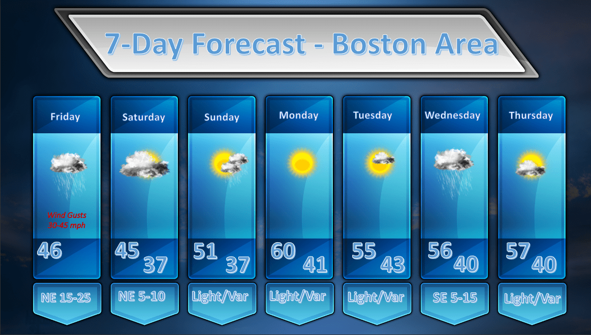
The good news is that this storm is now on its way out of the region as it completes the loop back toward the west that took place through Thursday night. Clouds and showers will remain a fixture in our weather through the rest of today but conditions should gradually improve with diminishing winds as we head into Saturday.
Speaking of Saturday, it looks like Saturday will be a less nice day than I’ve been thinking as the low level moisture, enhanced by NE winds feeding in Atlantic moisture, hangs tough. It will be less windy and it should also be fairly dry albeit cool and cloudy. Improving weather will move in by Sunday with the slight risk of a shower late in the day on Sunday and then Monday and Tuesday look like great days with temperatures above normal, light wind and sunshine.
It looks like a weak impulse will track south of our area on Wednesday and that will probably throw some rainfall back our way then. Next Thursday, at least for now, looks pretty good.
Stay healthy and safe out there!
