
Issued April 4 2020 – 3:30 pm
What a difference a day makes!
The rain and high winds that were spread all throughout Southern New England yesterday have been replaced by partly sunny skies and slightly warmer than expected temperatures.
The moisture that was expected to hang on in the lower levels of the atmosphere today dried out much faster than expected and we’ve been left with partly to mostly sunny skies across much of the region.
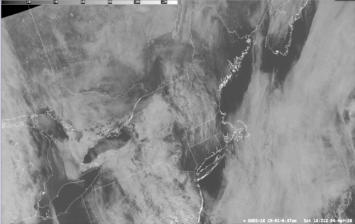
If you watch the satellite loop above which starts around 6am this morning and finishes around 2pm you can see the cloud layer that covered much of Southern New England burn away as the ocean storm pulls away to the SE. While this was not entirely expected, I doubt anyone is complaining about the extra sunshine we’re seeing today. :-). Closing out this look at the past, I felt like I would be remiss if I didn’t talk about how much rain we got in yesterday’s storm:
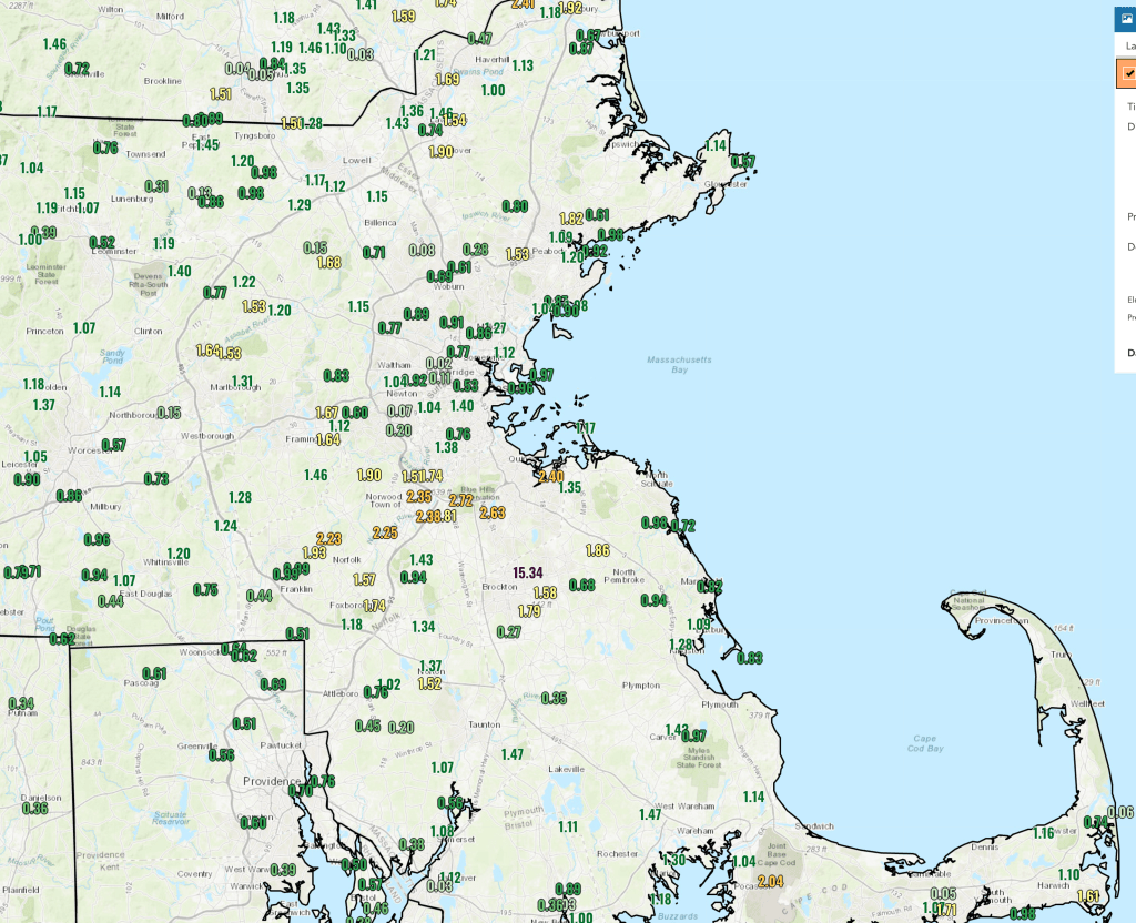
Eastern Massachusetts took the brunt of the rainfall from this system yesterday with over an inch of rain received in many areas. The jackpot for rainfall amounts was right near the Blue HIlls where 1.5 – 2.8″ of rainfall came down across a fairly small area near Milton, Norfolk, Foxborough and Norwood.
So, now that the big storm is by us, what’s next?
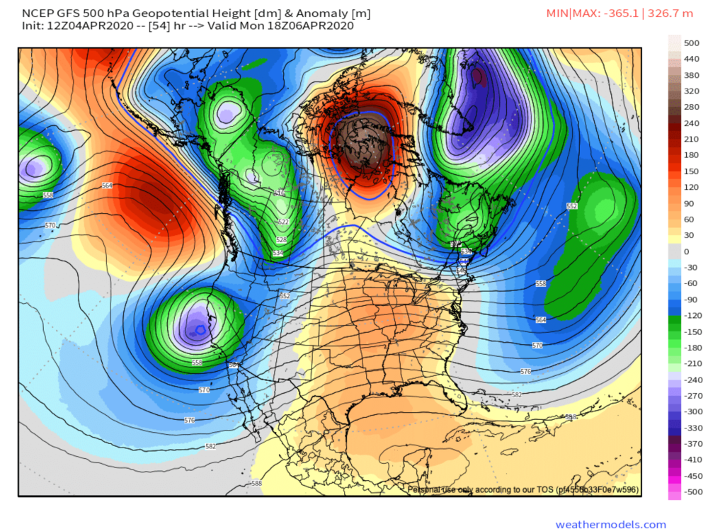
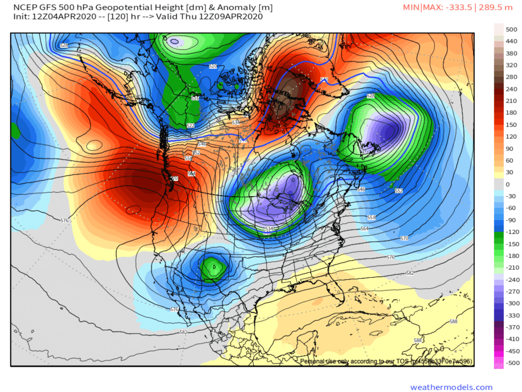
The two maps above show how the upper level pattern will be shaping up over the next 2-4 days. Starting on the left, looking at early next week, we will have a ridge of high pressure building through the mid section of the country which will lead to above normal upper atmospheric heights. This directly translates into warmer temperatures moving into the midwest and trying to poke into the Northeastern US. This should lead to rather pleasant conditions for us Sunday – Tuesday. On Sunday a weak cold front will slide across New England and may generate a shower or two late in the day.
The weather pattern is rather progressive in the mid latitudes meaning that systems are moving west to east at a fairly normal pace for this time of year. The blocking that was once present over the North Atlantic has retrograded back to Baffin Island in Canada. This is generally blocking any real serious shot of cold air from coming into the CONUS in the next 5-7 days.
By the mid – late part of this upcoming week the ridge will slide toward the east and a wave of low pressure will move to our south on Wednesday. This will likely throw a shield of rain on top of us Wednesday morning through the early evening.
A large upper low will move over the Great Lakes by Thursday morning. This is going to bring much colder weather into that area and will favor the formation of a storm system in southern Canada and this in turn is going to drag a cold front across our area by Thursday evening. This front may generate some precipitation for us here in New England in the later part of the day on Thursday. The details are still a little foggy with the Euro model showing the most precipitation over our area late Thursday. The GFS by contrast is much less aggressive with this system.
By Friday the upper air pattern has a very cold look for the northeast but, again, the details are in flux. The Euro model has a large upper low parked over eastern Canada and the northeast US. This should bring much below normal temperatures to the Northeast but it should be dry. The GFS holds back this feature to the west a bit which would favor a slightly warmer forecast but also a slightly wetter one.
The details of the longer range forecast will sort themselves out in the next couple of days.
