Issued April 5 2020 – 11:30 am
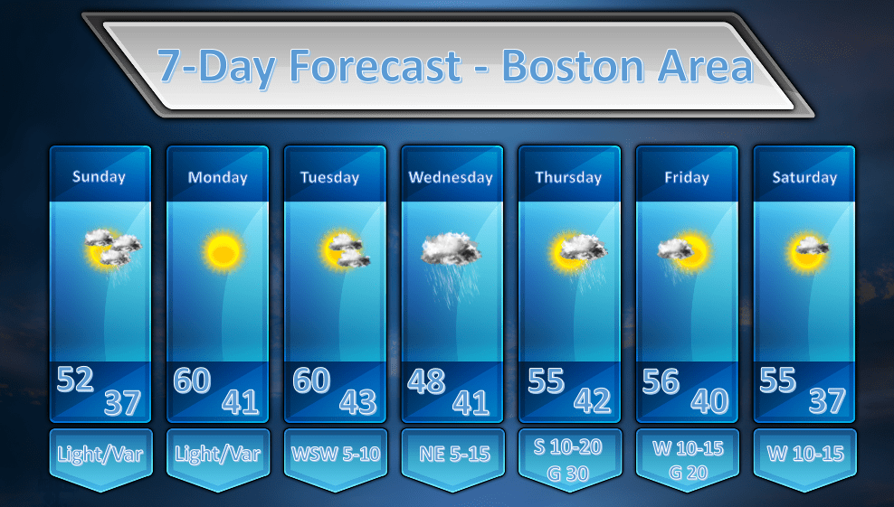
The weather forecast continues to look fairly tame for the next several days as the atmosphere settles down after a fairly active period.
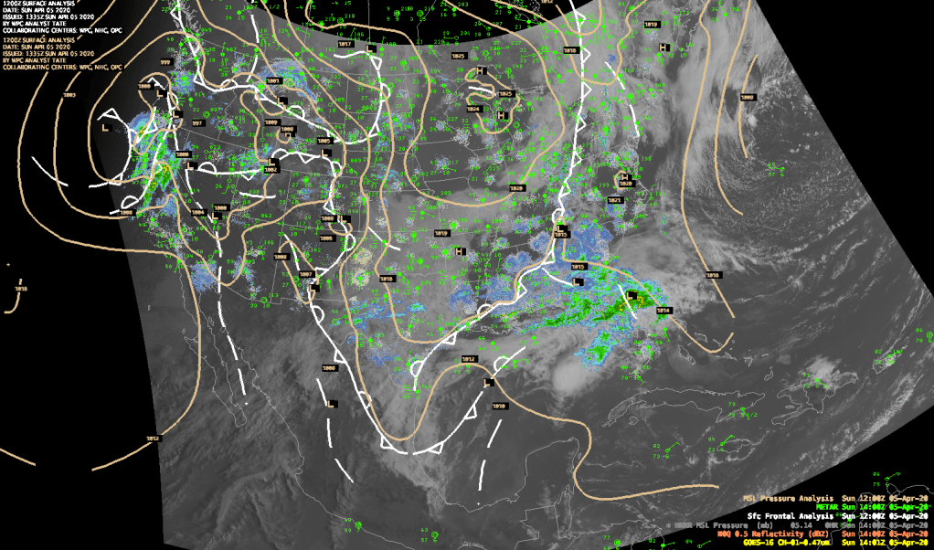
The dominant feature on this morning’s weather map is a cold front the extends down from a low pressure area just east of James Bay. This front doesn’t pack much of a punch and there are just a few showers here and there along it. This front will pass through our area during the evening hours tonight with little fanfare. The most we might see as it passes through is a stray shower here and there. It will remain mostly cloudy today, unfortunately as low level moisture, being focused by a weak trough of low pressure at the surface, will hang in.
By Monday winds will flip into a drier NW direction and that should clear us out. Once the sun is really able to work on the atmosphere we should start to see some spring time temperatures around here (finally!).
High temperatures both Monday and Tuesday look like they will make it into the upper 50’s and some places will push up into the lower 60’s. It should be a pair of beautiful days.
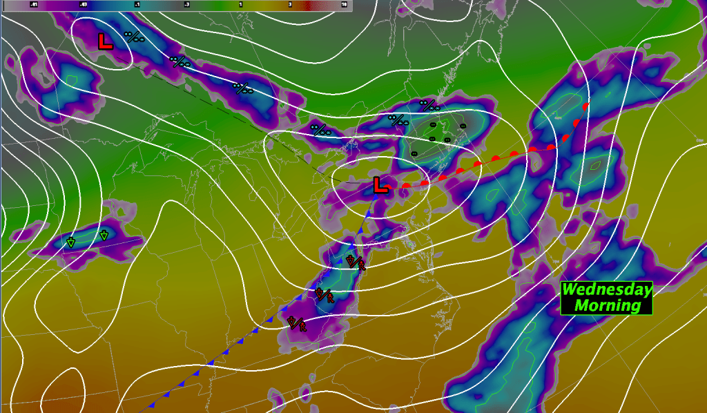
By Wednesday another low pressure system will be on the approach and this will bring us another round of rainfall. Don’t worry, this will not be the epic kind of rainfall that we saw on Friday. This storm will be weaker and will also keep moving along rather briskly. .25-.60″ of rainfall will probably do it generally for this storm. Heaviest rainfall will be focused over eastern MA.
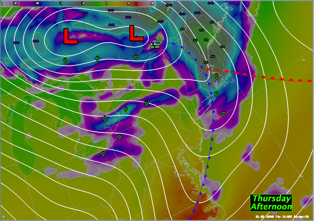
The next weather event will arrive quickly in the form of a cold front that will push into our area Thursday afternoon. The exact timing of the frontal passage isn’t 100% clear yet but I would favor slightly later in the afternoon over earlier but that will become clearer as the models lock on to this feature a little better. Either way it looks like we will see some showery weather for Thursday as this front moves through but it shouldn’t be a wash out by any means. .15-.25″ of rainfall in showers will be possible.
The front will slide off shore by Friday and the remainder of the week looks pleasant with partly sunny skies for the most part. My confidence in the temperature forecast out that far isn’t high due to the fact that the models are forecasting a fairly strong closed upper low over the northeast US by Friday/Saturday. My thinking is that the GFS MOS guidance is a bit too warm in that time range but I find it hard to argue with the guidance that far out. So, I’m going with it for now but as time goes on I have a feeling we will be lowering the max temps for next weekend by a little bit.
