Issued: April 16, 2020 at 1:00am
FORECAST DISCUSSION:
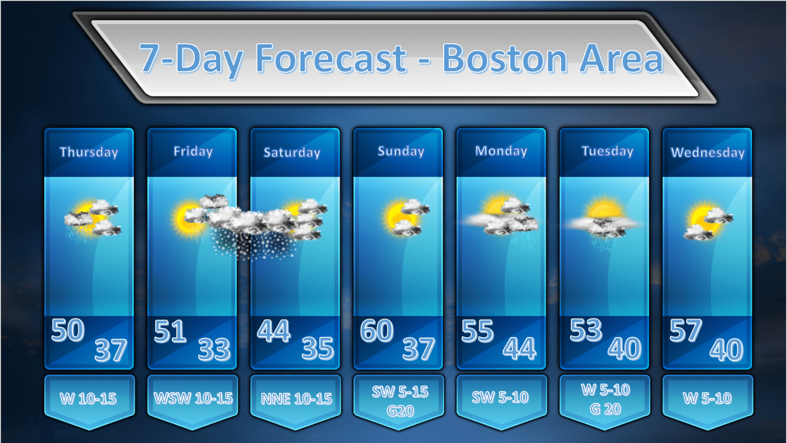
TODAY: During the early morning hours an upper level disturbance will be transiting across the area and this may generate a shower or two in the morning. This still looks like a fast mover and most of the rainfall should be over before or right around sunrise. The rest of the day will remain unsettled but largely dry as we will be under the influence of an upper level trough which will stimulate the growth of fair weather cumulus clouds during the afternoon. There isn’t too much fuel around for these clouds to grow into more substantial showers. Don’t be surprised however if you run into a sprinkle or two during the afternoon.
FRIDAY/SATURDAY: Friday should start off as a fairly nice day with mostly sunny skies. There will be a wave of low pressure approaching the region by afternoon and ascent caused by weak overrunning will throw a shield of cloudiness over the top of us by afternoon. As the day wears on showers and light snow, changing to mainly snow will start moving in after the dinner hour and the evening and overnight hours of Friday look miserable and cold. The GFS and ECMWF both want to bring a swath of accumulating snow across MA/RI and CT during Friday night through Saturday morning and both models are hinting at measurable maybe even plowable snow. Now, to be clear, we are not talking about a blockbuster storm by any means. We could, however, be talking about a short term light to moderate snow event ending mid-morning on Saturday. Of course there is quite a lot of time for this to change and I’m also having a hard time believing that we will see as much snow as the operational runs of the models are suggesting given the temperatures and the fact that both ensemble runs of the GFS and ECMWF are bucking against accumulating snow but given the agreement between the op models and the time of year (the atmosphere is still cold) I have to throw it in. Stay tuned and I will refine this tomorrow and Friday.
SUNDAY: Looks like a nice day with no weather systems immediately threatening the area. It should be mostly sunny and mild. By later in the day on Sunday clouds will advance from the north so as the sun is going down, skies will be probably be mostly overcast at that hour.
MONDAY: The models are making life miserable for mets in the long range as they appear to be gyrating a little bit. The models are now suggesting that an intensifying coastal storm will develop off the east coast on Monday. The storm deepens quickly as it slides to the southeast of New England by Monday night. Both the GFS and ECMWF take the storm just to the southeast of the 40N 70W benchmark and this should keep us out of any major precipitation associated with this storm. If the model solutions, as they are now presented, pan out, we shouldn’t even get any rain and temperatures would be able to get up into the 50’s. This is what I am forecasting as of now.
I am concerned about this situation, however, because we are dealing with a phasing of the northern and southern streams as the mechanism that will cause this storm to develop rapidly. The phasing, as of now, is advertised to happen after the storm moves by but as coastal development comes together in the models over the next few days it is possible that the timing of the phasing could change and happen earlier. If this happens we may be dealing with a more significant storm, passing by closer and, given the generally cold profile of the atmosphere, we could have to contend with snow possibilities for Monday night into Tuesday. This is many days away so stay tuned!
TUESDAY: If all goes well we miss the approaching storm and we are in a brisk westerly flow accompanied by sunshine by next Tuesday with highs in the low to mid 50’s.
WEDNESDAY: High pressure and dry air builds in and more spring-like temperatures return.
