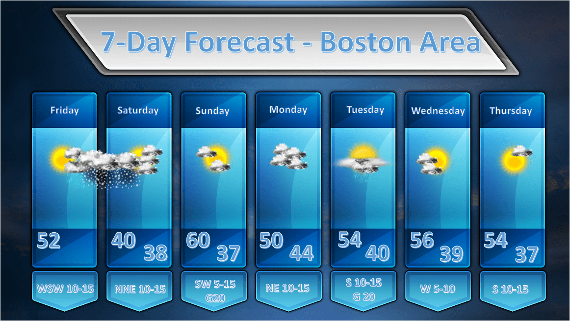
Issued: April 17, 2020 at 12:30 pm
***A LIGHT TO MODERATE SNOWFALL EVENT IS LIKELY TONIGHT INTO SATURDAY***
FORECAST DISCUSSION:
THIS AFTERNOON: A weak ridge of high pressure at the surface and aloft will allow us to have a very nice afternoon today. High temperatures will be a little on the cool side for this time of year, but not terribly so. Look for skies to be changeable through the afternoon as it is still fairly cold aloft and this will allow for some fair weather clouds to develop through sunset.
TONIGHT INTO SATURDAY: Ah, here is where things get interesting. A developing wave of low pressure moving through the Ohio River Valley late this afternoon will hop over the PA mountains overnight and redevelop south of New England. Along with all of this action will come a pretty substantial shield of precipitation. What form that precipitation will take is where the fun part of this forecast lives. We’ve got a few factors to consider here.
- Time of year. It’s definitely not the depth of winter but it is kind of chilly. Daytime highs today will be in the upper 40’s to around 50’s but the air is very dry with dew points in the teens. So, once the sun goes down, it will cool off very quickly. In addition to that, any precipitation falling into this dry coolish layer will allow the temperatures to fall even faster due to evaporational cooling.
- Amount of water content. If it were to snow anywhere east of 495 it would likely be a wet snow with snow to liquid ratios in the 7-8:1 range. So instead of the typical 10:1 ratio that we normally have where 0.10″ of liquid would equal about 1″ of snow, 0.10″ of liquid precipitation could translate into .7-.8″ of wet gloppy snow. Yuck. Water logged snow also does not accumulate efficiently as it tends to pack as opposed to stack up (the snow crystal being filled with water instead of air). So, more water content tends to lead to less accumulation.
- Time of day: This will happen at night when the atmosphere is at its coldest. As a colleague of mine pointed out to me last night, when the sun rises, given its angle at this time of year, it will warm the atmosphere quickly and that will tend to lead to the end of the snowfall and cause rapid melting/evaporation of the snow that has fallen. So, the window of time for accumulating snow will be limited to the time of the start of the snow until an hour or two after sunrise. After that, it’s over.
- Elevation: Given that the atmosphere is not just a horizontal system you have to take a look at what’s happening above the ground as well. Temperatures, as you go up vertically in the atmosphere are pretty cold. That’s why we keep getting afternoon cloudiness due to instability. Yes, it does normally get colder as we go higher up but the rate of cooling is also critical. That could turn out to be an important factor in the evolution of this storm. Given that temperatures are decreasing rapidly with height, anywhere with elevation like say the Worcester hills or the Berkshires could potentially see more snow as it will stay colder there for a longer period of time.
Those are just a few things that go into the snowfall accumulation equation.
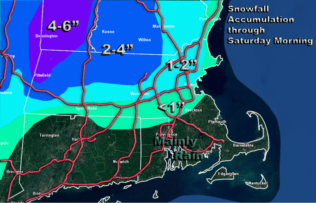
Then we have the models. Oh what fun we are having there. Some models are going light on this thing like the ECMWF and GFS. Other models have a more aggressive but not too crazy view like the NAM and Canadian regional model. Other models like the 3 km NAM and HRW WRF-ARW are going bonkers with 6-10″ amounts around Worcester and 4-6″ amounts near Boston. I just can’t see that happening. So, here is my best SWAG at snowfall amounts from this storm. I think the hilly areas of Worcester county may see amounts in the 2-4″ range along with parts of the Berks. Higher elevations and the colder areas of southern Vermont will see higher amounts as they will have the better snow to liquid ratios. In Boston proper you might see a slushy accumulation, if that. North and west of the city in the immediate suburbs you could see 1-2″ mainly on grassy surfaces.
SUNDAY: Looks like a nice day with no weather systems immediately threatening the area. It should be mostly sunny and mild. By later in the day on Sunday clouds will advance from the north so as the sun is going down, skies will be probably be mostly overcast at that hour.
MONDAY: Computer models are still showing an intensifying coastal storm off the east coast on Monday. The storm deepens quickly as it slides to the southeast of New England by Monday night. It appears at this time, however, that it will pass too far to our south to bother us much. The Cape and Islands will probably see some rain out of this system and strong gusty winds but thats about it. The ECMWF model is a little more aggressive with the rainfall as it brings some measurable precip up to Boston but I don’t think this is likely unless the storm track shifts further to the northwest. The EC is definately the outlier model. So, Monday looks like a cloudy day but fairly dry.
TUESDAY: Looks like a decent day with a brisk southerly flow ahead of an approaching cold front. There may be a shower or two as the front passes with highs in the low to mid 50’s.
WEDNESDAY: High pressure and dry air builds in and more spring-like temperatures return.
THURSDAY: A fine day, with highs in the mid 50’s and a southerly breeze.
