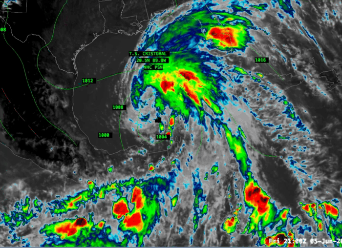
Back on June 1 tropical depression #3 formed near the Yucatan Peninsula which then became Tropical Storm Cristobal on June 2. Cristobal then zig zaged around in the southern Gulf of Mexico off the coast of Mexico for a bit before coming ashore on June 3rd. Cristobal then became a tropical depression again while meadering around the south of Mexico and dumping a massive amount of rainfall. Today Cristobal crossed back into the Gulf of Mexico near the city of Merida, Mexico.
With access to the warm waters of the Gulf of Mexico Cristobal has once again strengthened into a tropical storm.
Cristobal does have the potential to impact the Gulf coast of the United States as steering winds along the western edge of a large Atlantic high pressure area draw the storm northward. Current track forecasts seem to bring Cristobal up to near New Orleans by Sunday afternoon.

The guidance envelope seems to be tightly clustered on the location and timing of the arrival of Cristobal at the Louisana coast.
In terms of intensity, Cristobal does not look destined to become Hurricane Cristobal. The hurricane model intensity guidance shows Cristobal intensifying to around 50 kt (~60 mph) before he reaches landfall on Sunday. Some models make him a little stronger and some a little weaker.

This forecast is well supported by the sea surface temperatures which are still a little on the cool side for the development of a major hurricane to take place.

Cristobal has emerged into SST’s of 26-28C. You need SSTs to be around 27C to sustain tropical development so these relatively cool, borderline, SSTs should hold Cristobal together up to the Gulf coast but are not conducive to rapid intensification. It seems like Cristobal should remain below hurricane strength or may get close to Cat 1 if he gathers up a pulse of strength before landfall.
So, we should expect to see tropical storm warnings at the very least for the Louisiana and Mississippi coasts by tomorrow evening.
