***NEW FEATURE! You can get these forecasts and blog entries delivered directly to your e-mail. Click the button at the bottom of this post to subscribe!***
Issued: Wednesday June 10 2020 6:00 am
3-DAY FORECAST:
TODAY: A mix of clouds and sun and becoming more humid through the day. SE winds 5-10 mph with gusts to 20. High temperature 70-75 near the coast, 75-80 inland.
TONIGHT: Mostly cloudy. Winds SE to SW 5-15 mph with a few higher gusts. Lows 60-67 warmest in western CT.
THURSDAY: Cloudy and quite muggy with the risk of a shower or thunderstorm during the afternoon. Winds SW 10-15 mph. Highs 75-80.
THURSDAY NIGHT: Mostly cloudy with some partial clearing toward morning. Winds SW becoming NW 5-10 mph. Low temp 60-65 eastern MA/RI/E CT. 55-60 western MA/CT.
FRIDAY: Partly to mostly sunny with much lower humidity. Winds W-SW with some higher gusts. High temperature 80-85.
EXTENDED FORECAST:
SATURDAY: Partly sunny with afternoon thunderstorms possible. High 75-80.
SUNDAY: Partly cloudy with low humidity. High 70-75.
….CLOUDS STREAM OVER SNE, A FEW SUNNY BREAKS ARE POSSIBLE HERE AND THERE….
It’s a grey looking morning out there for much of eastern MA and RI as a streak of mid and low level cloudiness moves over the area. To the SW over CT and western MA skies are sunny but I’m not sure how far east that clearing will work. I think we may see a few breaks in the overcast as the day wears on but I suspect we are going to see more clouds than sun on average.
Temperatures will be fairly moderate today with a high near 80 degrees with low humidity.
Tomorrow we will see a day much like today with a fair amount of clouds with some breaks and temperatures near 80. The humidity should still be in the comfortable range but muggier air will be pressing into CT, RI, and western MA late in the day and that humidity should spread over all of SNE by Thursday.
***NEW FEATURE! You can get these forecasts and blog entries delivered directly to your e-mail. Click the button at the bottom of this post to subscribe!***
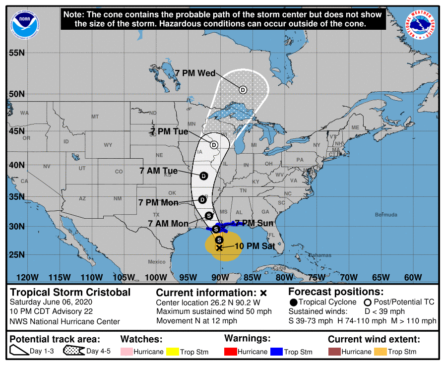
Tropical Storm Cristobal Tropical Cyclone Update NWS National Hurricane Center Miami FL AL032020 510 PM CDT Sun Jun 07 2020
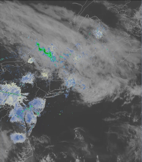
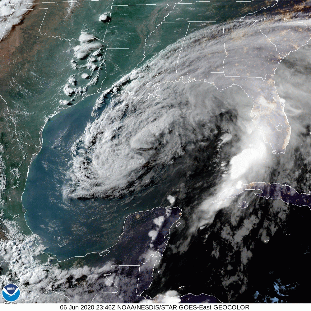
Satellite, radar, and surface data indicate that the center of Tropical Storm Cristobal made landfall at 500 PM CDT (2200 UTC) along the coast of southeast Louisiana between the mouth of the Mississippi River and Grand Isle. Maximum sustained winds were estimated near 50 mph (85 km/h) with a minimum central pressure of 992 mb (29.29 inches).
A Weatherflow site on Ship Island, Mississippi, has recently observed a sustained wind of 48 mph (78 km/h) and a gust to 64 mph (104 km/h). A Weatherflow site near Gulfport, Mississippi recently reported a sustained wind of 46 mph (74 km/h) and a gust to 60 mph (96 km/h).
SUMMARY OF 500 PM CDT…2200 UTC…INFORMATION
LOCATION…29.3N 89.8W ABOUT 50 MI…80 KM SSE OF NEW ORLEANS LOUISIANA MAXIMUM SUSTAINED WINDS…50 MPH…85 KM/H PRESENT MOVEMENT…N OR 355 DEGREES AT 7 MPH…11 KM/H MINIMUM CENTRAL PRESSURE…992 MB…29.29 INCHES
As of 1 pm today Tropical Storm Cristobal was located 30 nautical miles S-SE of Grand Isle, LA and 90 mi south of New Orleans, LA. Cristobal remained at a fairly steady state overnight and this morning with maximum sustained winds of 50 mph. Cristobal is moving toward the north at 5 mph.
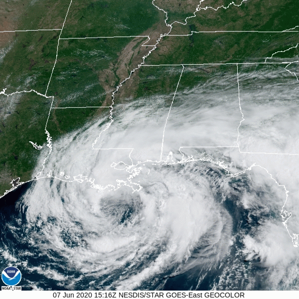
Hurricane Model Guidance for Tropical Storm Cristobal
Cristobal should continue to move slowly toward the north or northwest for the next several hours heading for a landfall along the LA coastline sometime between 7pm and 9pm this evening. After landfall Cristobal will continue to move toward the NNW near New Orleans and then up into AR by Monday evening.
The main effects of Cristobal will be storm surge, heavy rain, and weak spin up tornadoes.
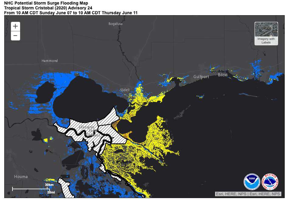
NHC Potential Storm Surge Flooding Map
The storm surge forecast hasn’t changed very much since last night with the focus of the storm surge continuing to be from the mouth of the Mississippi River to Ocean Springs, MS.
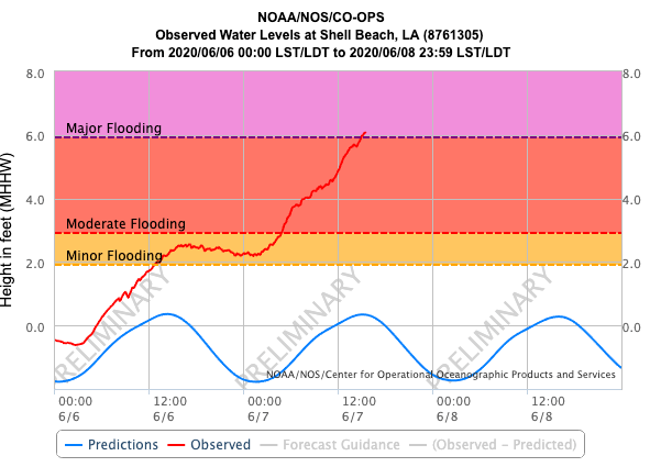
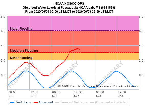
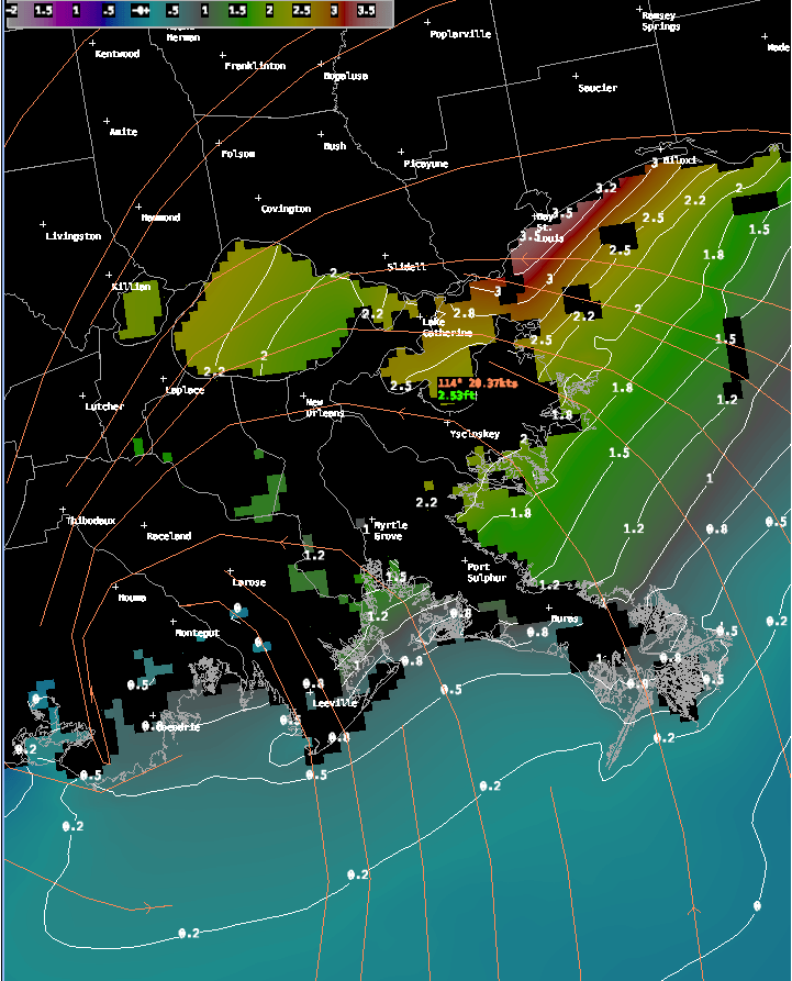
Some minor to moderate storm surge flooding is occuring at some stations along the LA and MS coasts. The worst station appears to be Shell Beach LA with a nearly 6′ storm surge occuring and the potential for major flooding in the area.
Observed Water Levels at: Left: Shell Beach, LA. Middle: Bay Waveland Yacht Club, MS. Right: Pascagoula NOAA Lab, MS
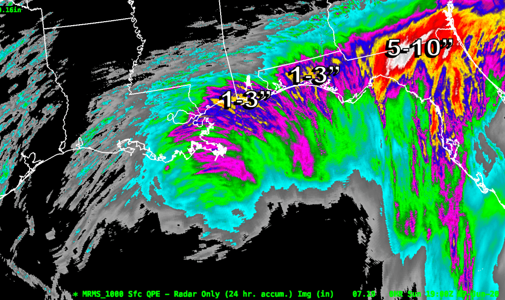
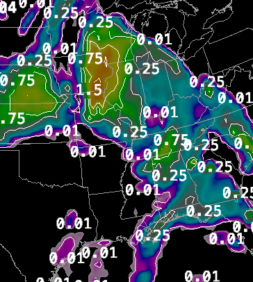
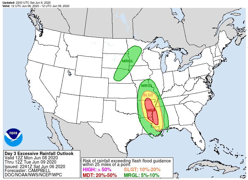
Rainfall has also been a significant factor with this storm. Very heavy rainfall occured yesterday in northern Florida with 5-10″ of rain being generated by band after band of heavy showers.
The next major threat area for heavy rain will be between New Orleans and the FL/AL border where there have been 1-3″ of rainfall thus far. Another 4-5″ of rainfall may fall in that area between now and Monday morning.
The inland threat of heavy precipitation is also still very much in play with heavy rainfall predicted for the central US from LA northward to WI.
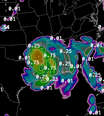
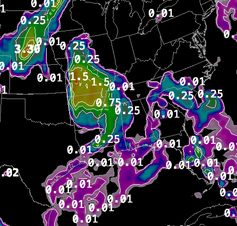
12 hour NAM Precipitation Forecasts – Left: Rainfall through 8am Monday to 8pm Monday. Middle: Rainfall through 8pm Monday to 8am Tuesday. Right: 8am Tuesday through 8pm Tuesday
Wind is a factor with this storm but not as significant when compared to the rainfall and storm surge flooding. Cristobal is throwing 35-45 mph winds up toward the LA and MS coast line and there are gusts of up to 55 mph as the stronger showers or thunderstorms pinwheel in from the Gulf. Thankfully, Cristobal does not have very destructive winds associated with it.
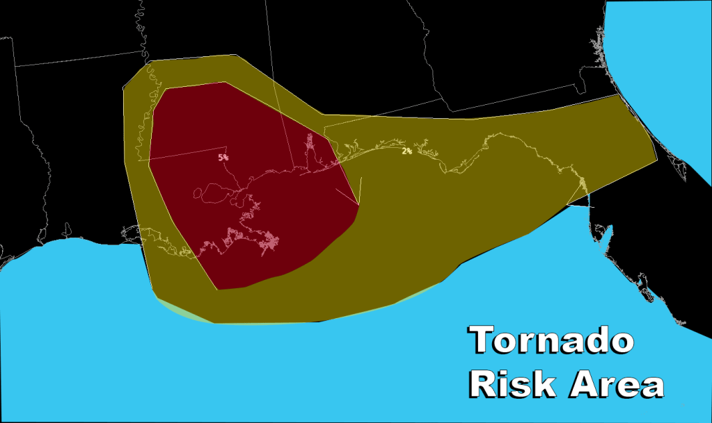
Tornado activity is also still a problem as Cristobal approaches the Louisiana coastline. Waterspouts and tornadoes have been reported along the Gulf Coast and in Florida today. The focus of the tornado potential will be in eastern LA and southern MS and along the Gulf Coast to north central FL.
We will continue to follow Cristobal as it makes landfall.
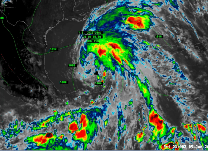
Tropical Storm Cristobal continues its journey through the middle of the Gulf of Mexico on its way to the Louisiana coastline. The latest advisory from the National Hurricane Center indicates that Cristobal is 210 mi S-SW of the mouth of the mouth of the Mississippi River.
10pm CDT National Hurricane Center Advisory for TS Cristobal
Cristobal has maximum winds of 50 mph and it is moving northward at 12 mph.
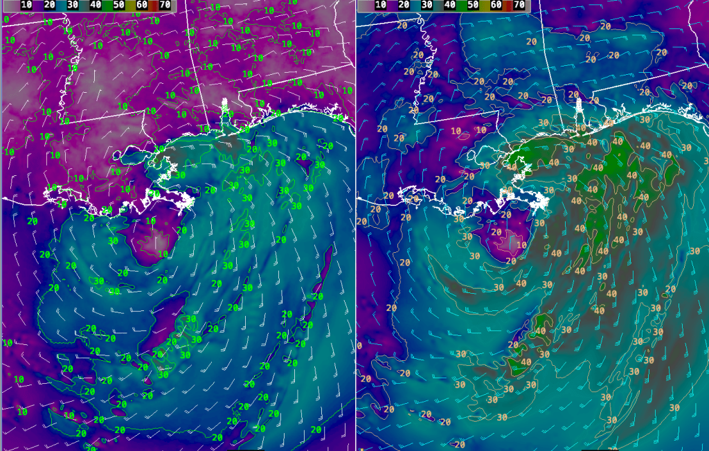
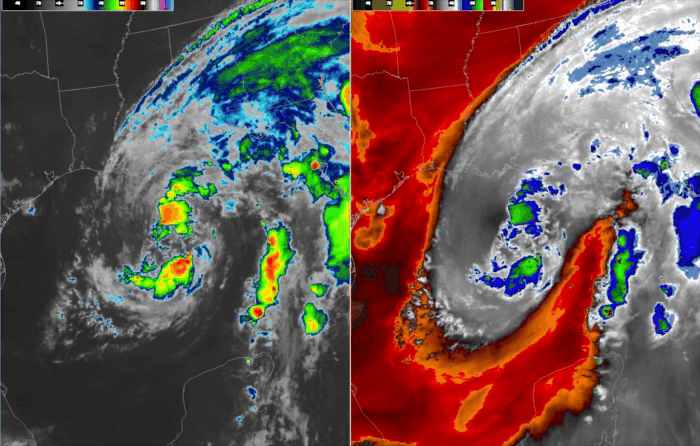
Looking at the satellite loop Cristobal is not a very impressive system. He does have a fairly well structured low level circulation but not very well organized deep convection near the center of the circulation. You need this to allow a tropical system to intensify, hurricanes are essentially large convection driven heat engines. The fact that there isn’t much organized convection near the center argues for a weaker system at landfall.
Satellite loops of Cristobal – Left: Infrared Image Right: Mid-level Water Vapor Image
The other thing that Cristobal is fighting off is dry air to the west and south of the storm that is entrained into the circulation of the storm. This is also preventing Cristobal from becoming better organized as the dry air inhibits the formation of thunderstorms and starves the storm of the heat energy that is generated by that process.
Further, the sea surface temperatures that Cristobal is moving over are around 27C which is the minimum temperature needed to maintain a tropical system. Lastly, there is wind shear in the vicinity of Cristobal. If you look at the northern portion of the storm’s circulation you can see the wind blowing the cloud formation rapidly from southwest toward the northeast. This wind shear is disrupting Cristobal’s circulation. Hurricanes cannot develop in an atmosphere with large amounts of wind shear in the environment.
The end result will be that Cristobal will not strengthen very much, if at all, before he reaches the Louisana coast. Cristobal should be a 50-60 mph tropical storm at most as it makes landfall.
So, what will the ultimate impacts of Cristobal be?
TIMING: I believe that Cristobal will reach the south coast of Louisiana by 7-9pm on Sunday. The models are in pretty unanimous agreement on this timing so I feel pretty confident in that forecast.
STORM SURGE: The storm surge guidance is indicating that 3-5′ storm surge is likely especially from the mouth of the Mississippi River up the coastline to Ocean Springs, MS. This is reflected in the 10pm CDT NHC advisory. It seems like the focus of the surge will be from 5pm Sunday – 5am Monday from Pearlington, MS to Biloxi, MS.
Storm Surge Forecast 8pm Sunday
In particular it looks like Bay St. Louis will pile up the water most efficiently as the wind direction will be blowing right into the mouth of the bay during landfall. Dangerous coastal inundation is possible. The other area of concern will be on the north side of Lake Pontchartrain during Monday morning where 2-4′ storm surge is possible. If this area is not well protected flooding may be possible in that area as well.
WINDS: Wind should not be a major factor with this storm system. This system is rather atypical of a stronger tropical storm or hurricane in that the strongest winds are displaced far out from the center of circulation. This is due to the disorganized state of this storm and I don’t expect that will improve much by tomorrow night. Winds along the coast may reach 40-50 mph east of the storm center along the MS coast with higher gusts up to 55-65 mph possible.
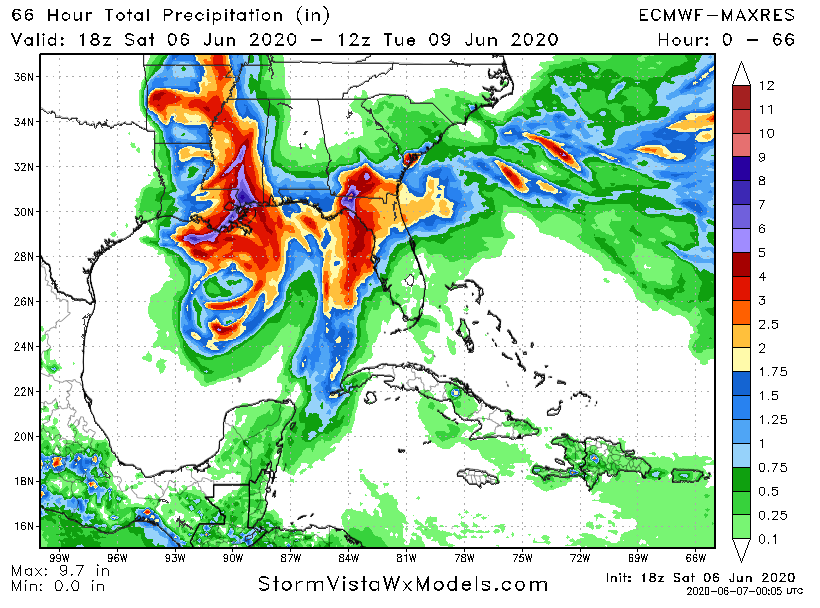
RAINFALL: Excessive rainfall is likely with Cristobal. The models have been bouncing back and forth on where the bullseye of the heaviest rain will be. It appears that there will be a general area of 5-8″ of rainfall focused on the eastern portion of Louisana around New Orleans eastward to the MS/AL border. Locally higher amounts, up to 10″ may be possible within this area. There is significant flooding potential with this kind of rainfall.
European Model Precipitation Forecast through 8am Tuesday
TORNADOES: Landfalling tropical systems tend to spawn tornadoes as the circulation interacts with the land and frictional forcing causes turbulence and rotation. These spin ups are scattered in nature and can take place at any time. The greatest risk for these spin up storms are on the west coast of the Florida panhandle and the SE portion of Louisana close to the mouth of the Mississippi River. This risk may spread into interior Mississippi during Monday.
INLAND EFFECTS: Heavy rain will move inland after Cristobal comes ashore and vast swaths of the midsection of the country could see rainfall amounts in excess of 4″ especially from southern Mississippi through southern Missouri. The potential for flash flooding will be elevated throughout this area.
Stay tuned for further blog updates. If you are reading this from a threatened area, please consult official sources if you need to make decisions concerning life and property.
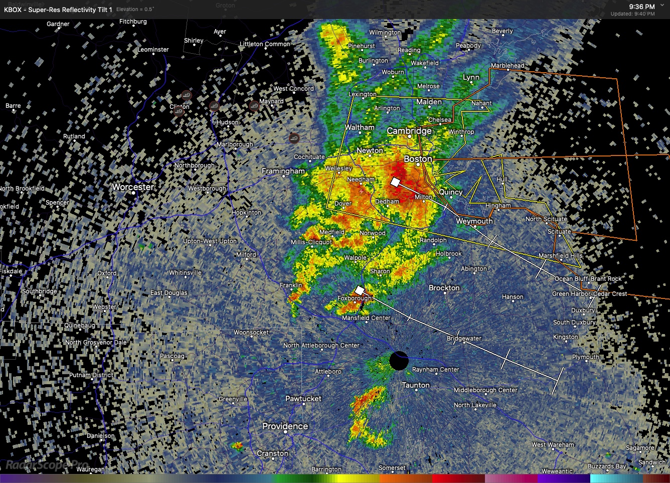
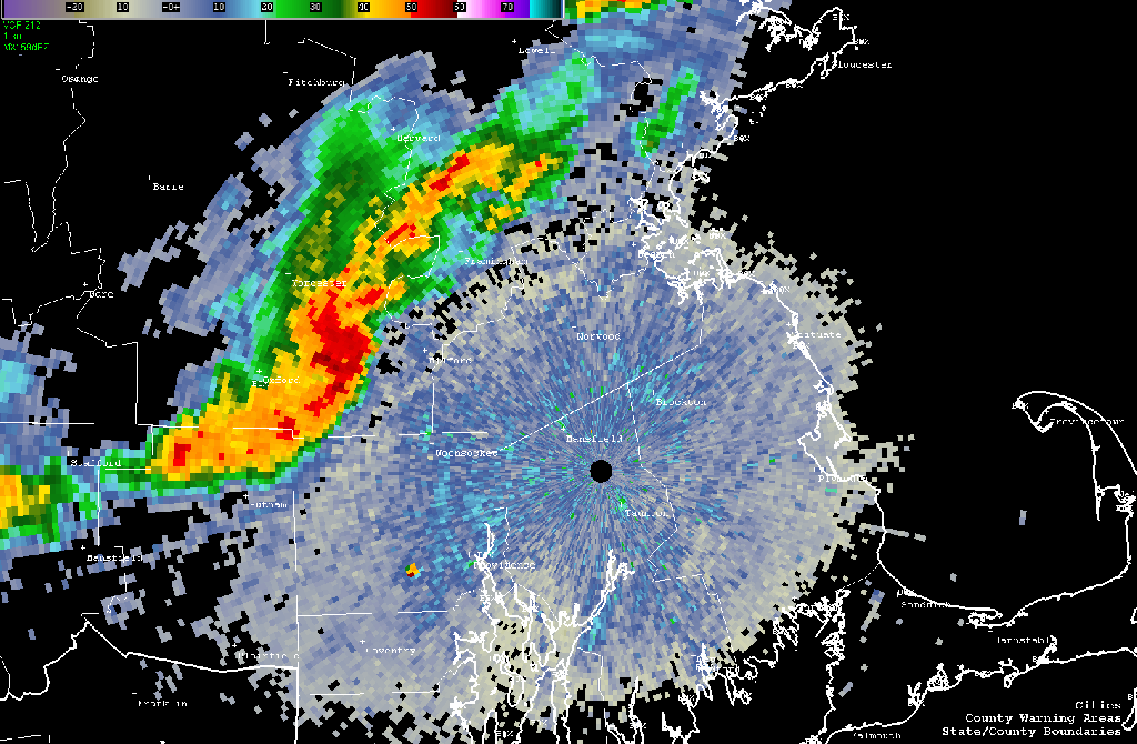
The severe thunderstorm that formed near Lancaster is now impacting the Newton, Needham, Dedham area and is moving toward the southeast and should be in the Holbrook, Weymouth, Hingham area in the next 25-30 minutes or so. This thunderstorm may contain strong winds and small hail. Doppler radar does indicate winds of around 30 mph associated with this storm just above the surface and these winds will likely come down to the surface in gusts as the storm passes through your area. Trees and power lines have been taken down by this storm in Stow and Sudbury, MA.
If you are in the path of this storm seek shelter.
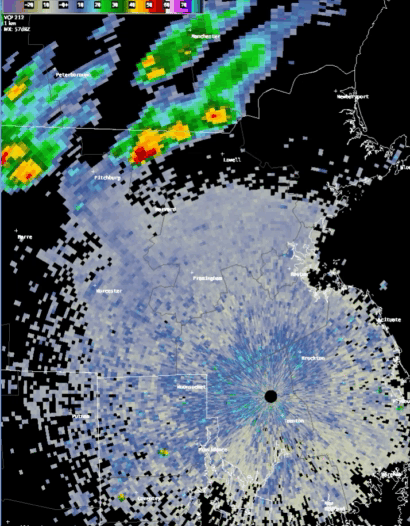
BULLETIN – IMMEDIATE BROADCAST REQUESTED Severe Thunderstorm Warning National Weather Service Boston/Norton MA 838 PM EDT Sat Jun 6 2020
The National Weather Service in Boston/Norton has issued a
Severe Thunderstorm Warning for… Southwestern Suffolk County in eastern Massachusetts… North central Norfolk County in eastern Massachusetts… Northeastern Worcester County in central Massachusetts… Central Middlesex County in northeastern Massachusetts…
Until 930 PM EDT.
At 837 PM EDT…a severe thunderstorm was located over Lancaster…or near Leominster…moving east at 30 mph. HAZARD…60 mph wind gusts and quarter size hail. SOURCE…Radar indicated. IMPACT…Expect wind damage to trees and power lines. Minor hail damage to vehicles is possible.
Locations impacted include… Boston…Cambridge…Newton…Somerville…Framingham…Waltham…Malden… Brookline…Medford…Arlington…Leominster…Marlborough…Woburn… Natick…Watertown…Lexington…Needham…Wellesley…Melrose and Wakefield.
PRECAUTIONARY/PREPAREDNESS ACTIONS…
For your protection move to an interior room on the lowest floor of a building.
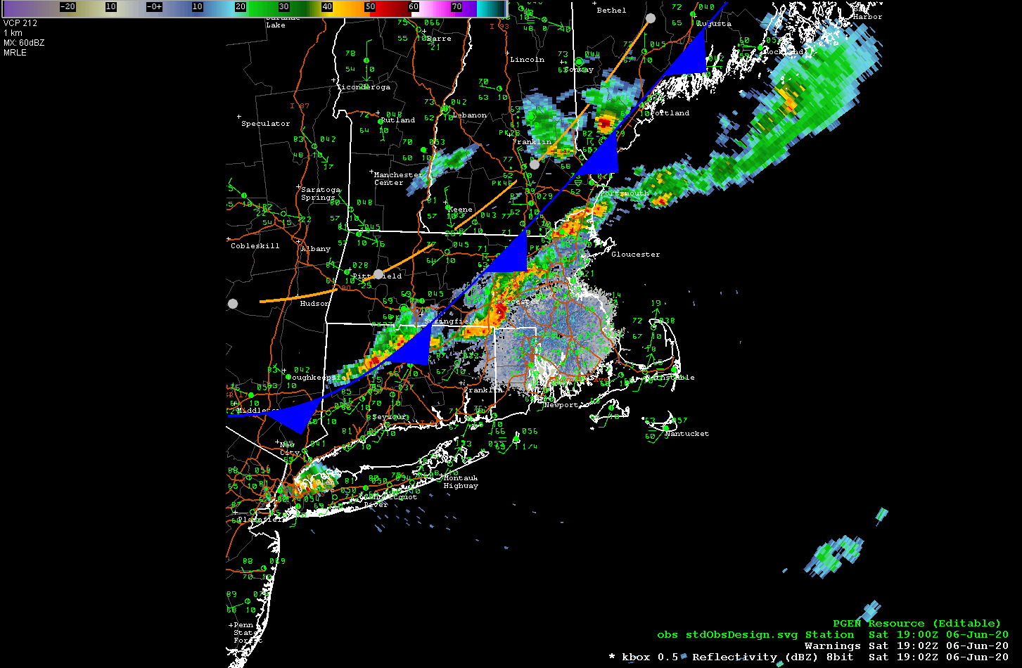
…COLD FRONT SLICING THROUGH SNE NOW, THUNDERSTORMS BLOSSOMING IN E MA…
A cold front is currently moving through central MA and NW CT and will push through all of Southern New England by this evening. There is a line of showers and thunderstorms developing in advance of the cold front and these storms are currently moving through the Uxbridge and Milford areas. There are also heavy showers and thunderstorms passing through the Framingham/Sudbury area. This line of storms look like they will move into the Newton, Norwood, Medfield area and then on to a Brockton to Weymouth line by around 4:00 pm.
This line of storms contains severe weather and the National Weather Service has issued a severe thunderstorm warning for much of the South Shore including Brockton, Stoughton, Easton, Mansfield, Attleborough, Bridgewater, Pembroke and Marshfield until 430pm EDT.
Back on June 1 tropical depression #3 formed near the Yucatan Peninsula which then became Tropical Storm Cristobal on June 2. Cristobal then zig zaged around in the southern Gulf of Mexico off the coast of Mexico for a bit before coming ashore on June 3rd. Cristobal then became a tropical depression again while meadering around the south of Mexico and dumping a massive amount of rainfall. Today Cristobal crossed back into the Gulf of Mexico near the city of Merida, Mexico.
With access to the warm waters of the Gulf of Mexico Cristobal has once again strengthened into a tropical storm.
Cristobal does have the potential to impact the Gulf coast of the United States as steering winds along the western edge of a large Atlantic high pressure area draw the storm northward. Current track forecasts seem to bring Cristobal up to near New Orleans by Sunday afternoon.
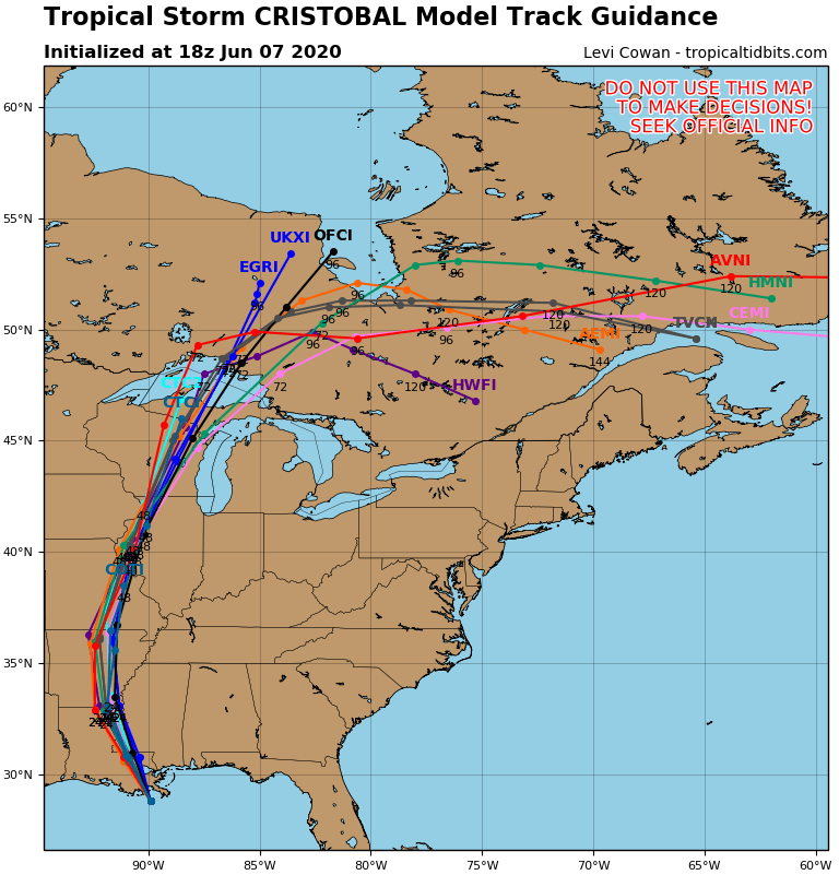
Model track forecasts for TS Cristobal
The guidance envelope seems to be tightly clustered on the location and timing of the arrival of Cristobal at the Louisana coast.
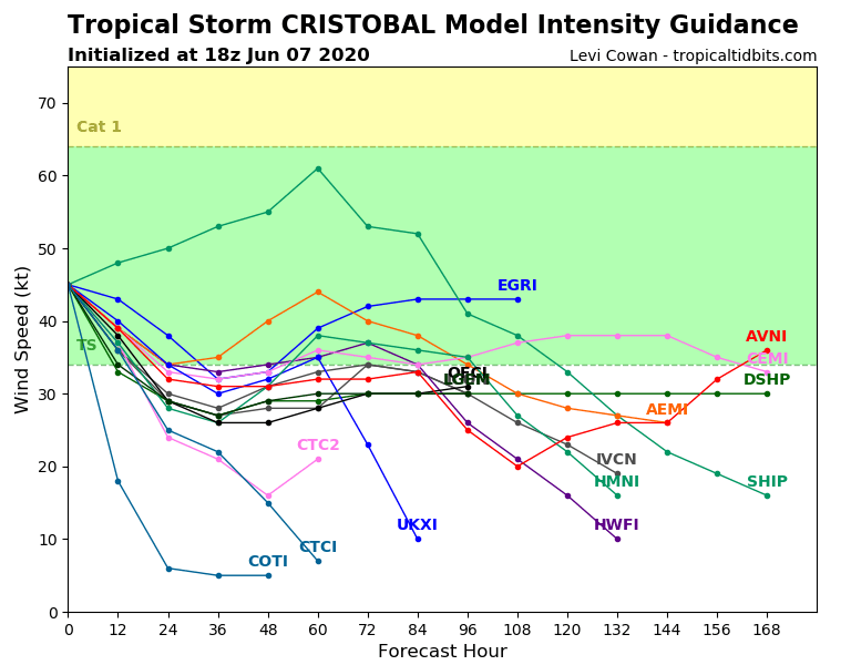
In terms of intensity, Cristobal does not look destined to become Hurricane Cristobal. The hurricane model intensity guidance shows Cristobal intensifying to around 50 kt (~60 mph) before he reaches landfall on Sunday. Some models make him a little stronger and some a little weaker.
Tropical Storm Cristobal Intensity Forecast
This forecast is well supported by the sea surface temperatures which are still a little on the cool side for the development of a major hurricane to take place.
Sea Surface Temperature (SST) Analysis 8am Friday June 5 2020
Cristobal has emerged into SST’s of 26-28C. You need SSTs to be around 27C to sustain tropical development so these relatively cool, borderline, SSTs should hold Cristobal together up to the Gulf coast but are not conducive to rapid intensification. It seems like Cristobal should remain below hurricane strength or may get close to Cat 1 if he gathers up a pulse of strength before landfall.
So, we should expect to see tropical storm warnings at the very least for the Louisiana and Mississippi coasts by tomorrow evening.