Southern New England Forecast

WEATHER SUMMARY:

….VERY ACTIVE WEATHER PATTERN OVER THE NEXT WEEK….

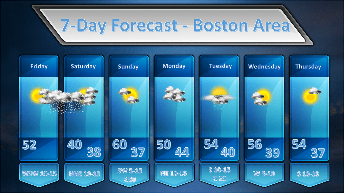
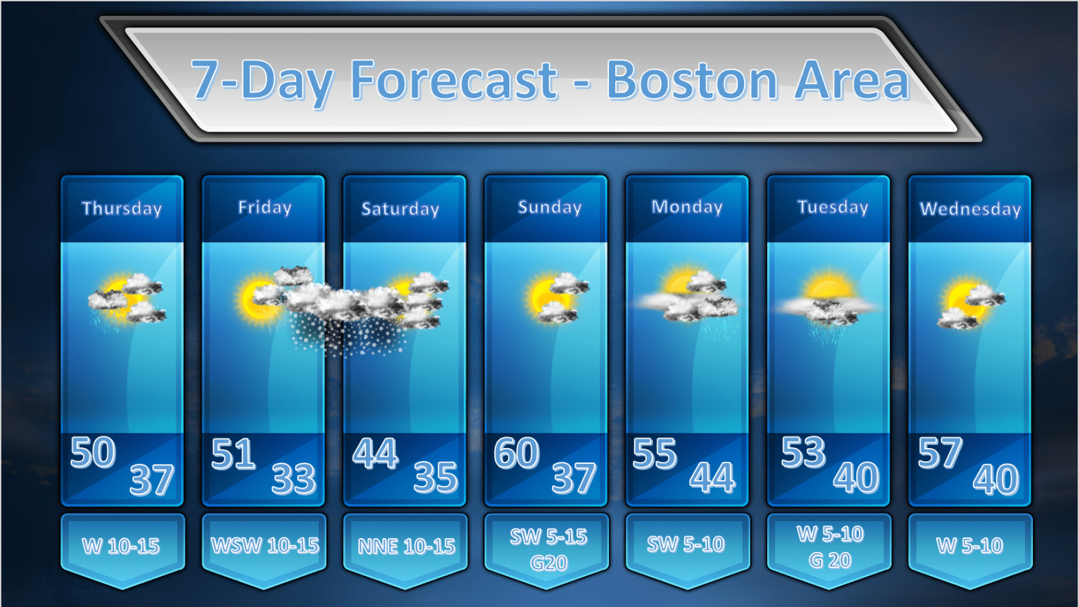
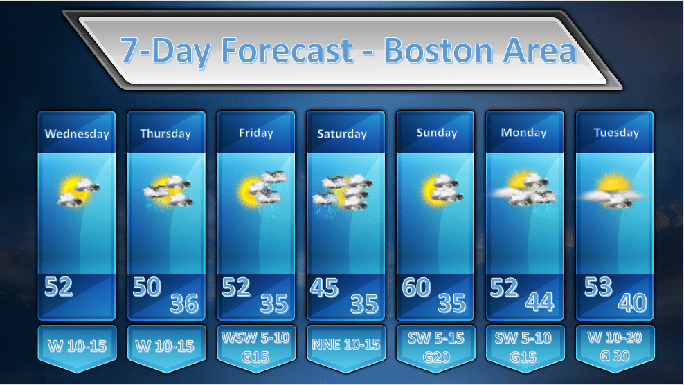
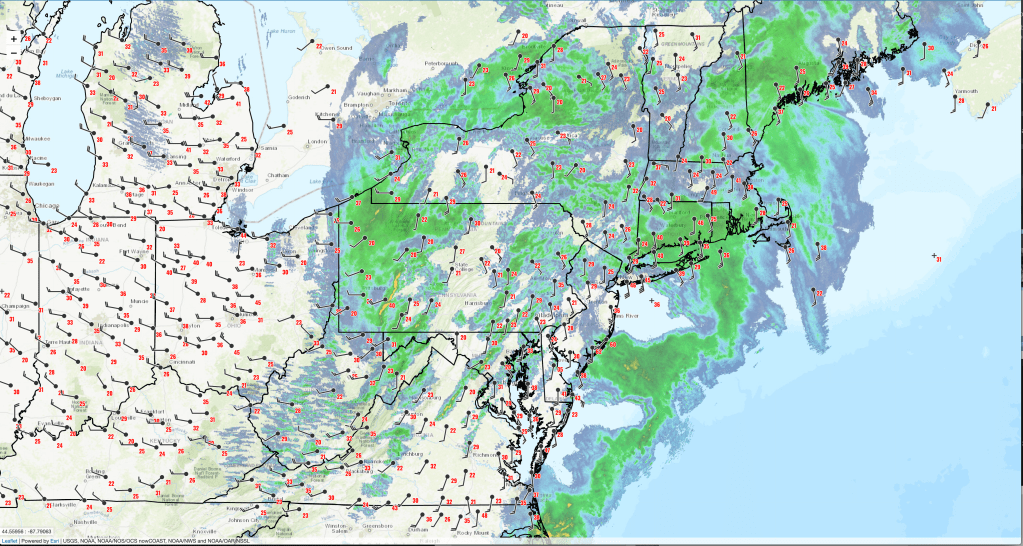
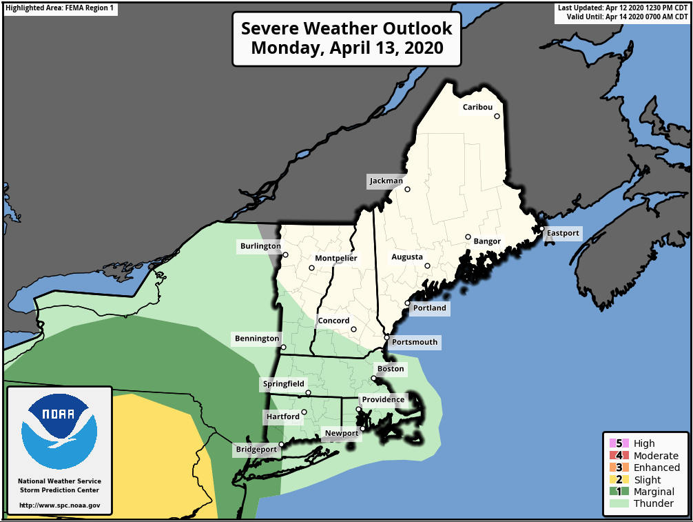
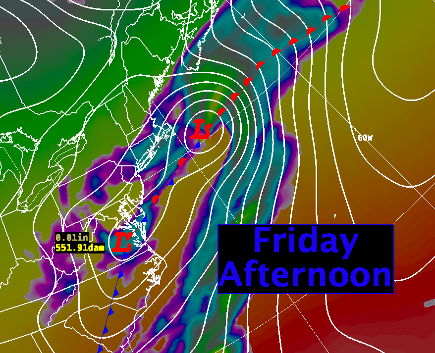
We have a very progressive and quite active weather pattern in our midst over the next week as no less than 3 storm systems will impact the Northeast. The first such system will be sliding south of New England during the day today and will bring along some light showers and even a period of steady rain. This first system is a fast mover so I’m not expecting much in the way of rainfall out of this system. Just expect gray, cool and gloomy weather for Friday.

Friday Afternoon’s Storm

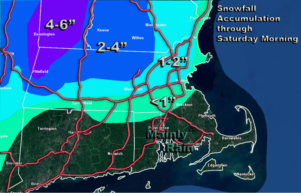
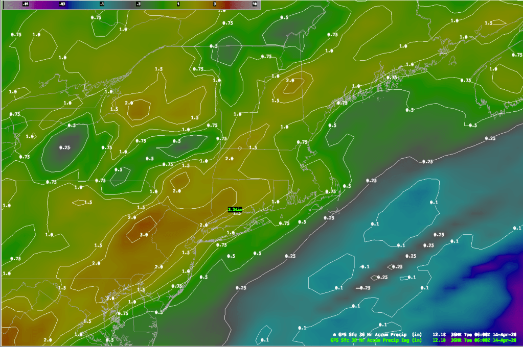
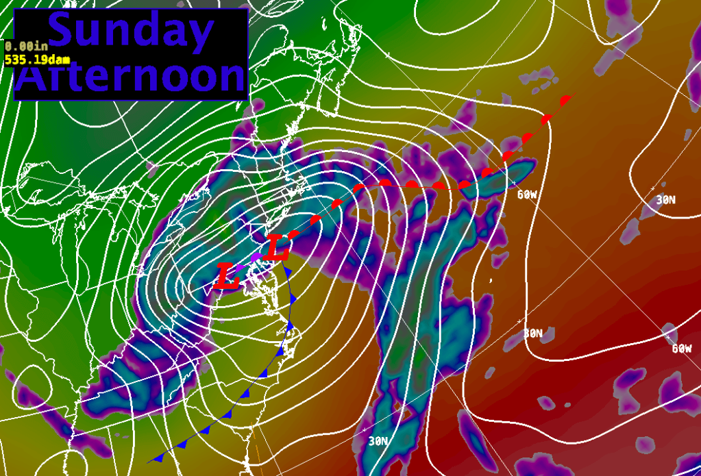
After we see some sun on Saturday the next system will be on us by Sunday. This next system starts of as a weak low pressure wave moving through the middle Mississippi valley. This system will team up with some upper level energy diving southward on Sunday and allow this storm to deepen quickly as it move northeastward into the Lower Great Lakes region by Sunday afternoon. As is typical with a lot of Spring weather systems, this low will intensify along the coast and stall out a bit. All of this will lead to about 0.80″ – 1.25″ of rainfall across all much of New England on Sunday.

Sunday soaker!

By Monday this storm will be moving slowly off to the northeast as an upper level cutoff low captures the storm and slows it way down leaving us with a cloudy and cool day with showers.

Storm number 3 will come at us toward the end of the forecast period with another dose of +1.00″ rainfall. Looks like it’s going to be very green around here this summer!

DETAILED FORECAST:

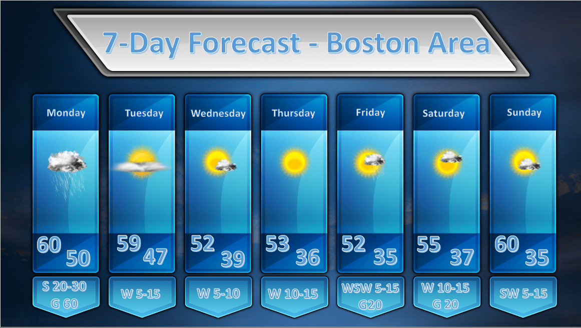
THIS MORNING: Overcast with periods of light rain. Winds NE 5-15 with gusts up to 20 mph especially near the coast. High temperature 42-48 degrees.

THIS AFTERNOON: Light rain tapering off and ending by mid-afternoon. Cloudy, continued cool and raw. Winds NE 5-15 mph gusting up to 20-25 mph especially along the south coast. High Temperature 42-47 degrees.

TONIGHT: Becoming mostly clear. Light winds. Low temperatures near 40 in the city, 30-35 in the suburbs.

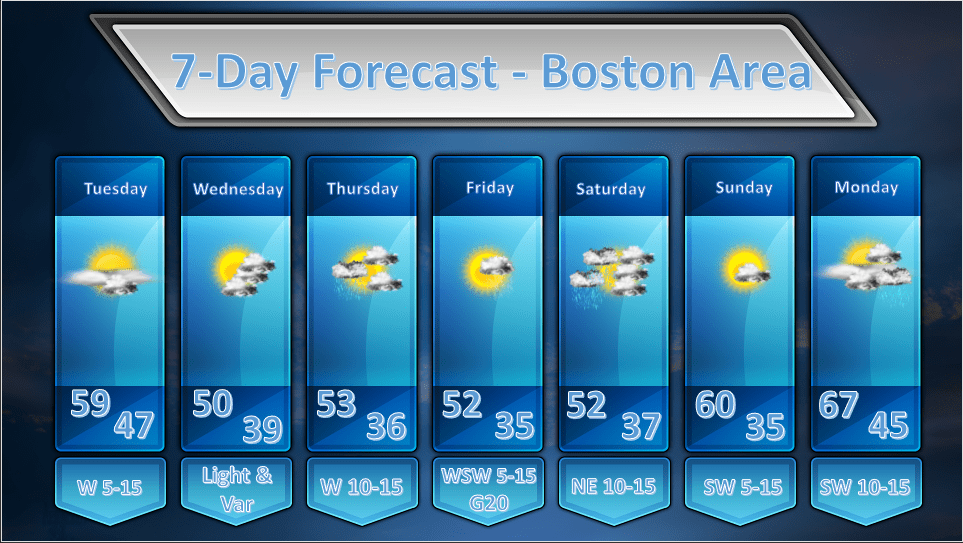
SATURDAY: Mostly sunny through afternoon. Increasing high cloudiness into the evening. Winds light and variable. High temperature in the mid 50’s in Boston 55-60 out to 495 and 60-65 in central and western Mass.

SATURDAY NIGHT: Lowering and thickening clouds throughout the evening and overnight hours. Winds light and variable. Low temperatures 32-40, warmest east.

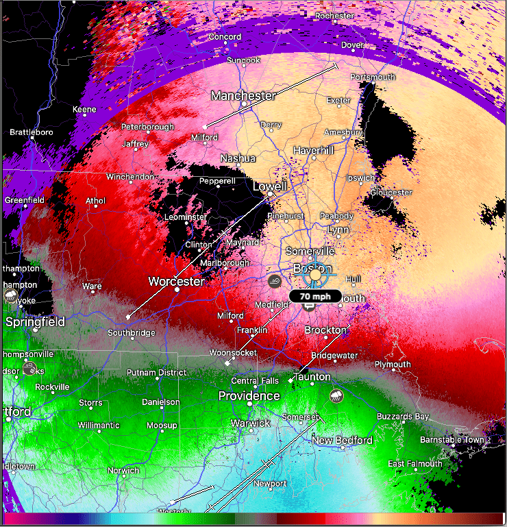
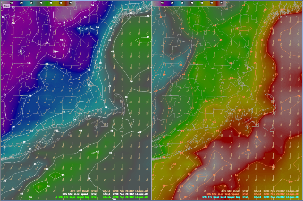
SUNDAY: Rain developing in the morning, becoming heavy at times in the afternoon. Winds 10-20 mph gusting 25-35. Strongest winds/gusts at the coast and on the Cape. High temperature 45-50.

SUNDAY NIGHT: Rain tapering off to showers in the evening and overnight. Cloudy and raw. Winds NE 15-25 gusting to 35-40 overnight. Low temperatures

MONDAY: Cloudy with showers. It will be breezy and raw. Winds NE to N 10-15 mph with higher gusts near the coast. High 45-50.

TUESDAY: Cloudy start with sunshine developing throughout the day. High in the mid 50’s east, low to mid 60’s in central and western MA.

WEDNESDAY: Sunny start with clouds increasing through the day. High temperatures 55-60.

THURSDAY: Cloudy with rain. High temperature 60-65.

Southern New England Forecast

Issued: April 22, 2020 at 3:30 pm

WEATHER SUMMARY:

*** FOR THOSE OF YOU THAT FOLLOW THIS BLOG, MY APOLOGIES FOR THE LACK OF POSTS THE LAST FEW DAYS. I HAVE BEEN WORKING ON A PROJECT THAT WILL ACTUALLY HELP ME DELIVER THIS TO YOU AND IT TOOK QUITE A BIT OF TIME AND EFFORT. VACATION IS OVER NOW. 🙂 ***

The weather pattern is looking quite active for the next few days as a quick succession of storms will make their way through the northeast. An upper level trough which swung into the area yesterday along with heavy rain (for some) still sits over the Northeast today. As a result we have rather cool conditions and generally unsettled weather. Radar does show a few returns around, especially north of Boston, but if there is any rain coming down it would be very light. As the sun goes down these showers will evaporate and we should have a clear and pretty chilly evening.

By Thursday, after a sunny start to the day, clouds will increase ahead of the next system that will bring us some rain. Thursday night into Friday a warm front attached to low pressure moving through the Ohio Valley will allow an area of rainfall to blossom over all of Southern New England. We will have clouds and mostly light rainfall throughout Friday as the low pressure area slides off the Middle Atlantic coast. The rain will come to an end by Saturday morning and we should see some sun before yet another low ejects out of the Tennessee Valley on Saturday and tracks into the Northeast by Sunday. Moderate to possibly heavy rainfall will develop early Sunday morning and continue into the early afternoon. Rain will taper off as the low pressure area tracks along the Maine coast out of our area during the overnight hours of Sunday.

Upper level low pressure will hang back over Nova Scotia on Monday morning providing enough instability for more afternoon clouds and showers to develop.

Finally, by Tuesday, the weather pattern will settle a bit and give us a pretty nice and seasonably warm day.

THIS AFTERNOOON: Variable cloudiness, breezy and cool with risk of a shower. Winds W 10-15 mph gusting to 20-25 mph. Temperatures through the afternoon 40-45

TONIGHT/OVERNIGHT: Mostly clear and cold. W 5-10 gusting 15-20 mph. Low temperatures around 30 in the city, 20-25 in the suburbs.

THURSDAY: A sunny start with lowering and thickening clouds moving in after lunch. Winds W-SW 5-15 mph. High temperature 50-55.

THURSDAY NIGHT: Cloudy with rain developing toward midnight. Light rain through the overnight hours. Winds light and variable. Low temperature 35-40.

FRIDAY: Overcast with periods of light rain. Winds NE 5-15 with gusts up to 20 mph especially near the coast. High temperature 42-48.

FRIDAY NIGHT: Periods of light rain and raw. NE wind 5-15 with gusts 20-25, strongest at the coast. Low temperature near 40 in downtown Boston, 32-37 in the suburbs.

SATURDAY: Mostly sunny with clouds increasing after sunset. Rain developing in the evening. Winds NE to E 5-10 mph. High temperature near 50 in Boston 55-60 away from the coast.

SUNDAY: Rain, heavy at times through the morning hours. Tapering off by afternoon. Remaining cloudy, breezy and cool. High temperatures near 50.

MONDAY: Cloudy with showers and light winds. High near 50.

TUESDAY: Mostly Sunny. High near 60.

Spotter Reports from April 17/18 Event

NOUS41 KBOX 182009
PNSBOX
CTZ002>004-MAZ002>024-026-RIZ001>008-190809-

Public Information Statement
Spotter Reports
National Weather Service Boston/Norton MA
409 PM EDT Sat Apr 18 2020

The following are unofficial observations taken during the past 20
hours for the storm that has been affecting our region. Appreciation
is extended to highway departments, cooperative observers, Skywarn
spotters and media for these reports. This summary also is available
on our home page at weather.gov/boston

********************STORM TOTAL SNOWFALL********************

LOCATION          STORM TOTAL     TIME/DATE   COMMENTS
                     SNOWFALL           OF
                     /INCHES/   MEASUREMENT

CONNECTICUT

...Hartford County...
   Burlington             5.5   840 AM  4/18  Public
   Canton                 3.5   852 AM  4/18  Trained Spotter
   West Hartford          3.0   643 AM  4/18  Public
   North Granby           2.5   904 AM  4/18  Trained Spotter
   Bradley AP             2.4   839 AM  4/18  Airport
   East Farmington Heig   1.9   616 AM  4/18  Trained Spotter
   Enfield                1.0   850 AM  4/18  Ham Radio

...Tolland County...
   Tolland                5.5   635 AM  4/18  Trained Spotter
   Coventry               4.2   624 AM  4/18  Trained Spotter
   WILLINGTON             3.5  1045 AM  4/18  NONE
   Staffordville          3.0   806 AM  4/18  Co-Op Observer
   Andover                1.0   643 AM  4/18  Ham Radio
   Columbia               1.0  1040 AM  4/18  Trained Spotter

...Windham County...
   Pomfret Center         5.0   647 AM  4/18  Trained Spotter
   Woodstock              4.5   619 AM  4/18  Ham Radio
   Pomfret                4.5   749 AM  4/18  Trained Spotter
   Ashford                3.6   721 AM  4/18  Ham Radio
   Moosup                 1.0   526 AM  4/18  Ham Radio

MASSACHUSETTS

...Barnstable County...
   Truro                  3.0  1020 AM  4/18  Broadcast Media

...Bristol County...
   Taunton                2.0   708 AM  4/18  Ham Radio
   Attleboro              2.0   701 AM  4/18  NWS Employee
   Norton                 1.8   838 AM  4/18  NWS Office
   Acushnet               0.5   608 AM  4/18  Ham Radio

...Essex County...
   Lynn                   3.0   952 AM  4/18  Ham Radio
   Saugus                 3.0   934 AM  4/18  Ham Radio
   Haverhill              0.5   851 AM  4/18  Ham Radio
   Ipswich                0.5   733 AM  4/18  Trained Spotter

...Franklin County...
   Ashfield               4.5  1121 AM  4/18  NONE
   New Salem              3.5  1100 AM  4/18  Trained Spotter
   Leyden                 3.2   945 AM  4/18  NONE
   Heath                  2.1  1223 PM  4/18  Ham Radio
   Northfield             2.0   650 AM  4/18  Public

...Hampden County...
   Monson                 4.3   820 AM  4/18  Ham Radio
   Southwick              3.0   849 AM  4/18  Ham Radio
   North Chester          2.8   805 AM  4/18  Trained Spotter
   Westfield              1.6   910 AM  4/18  Media
   Longmeadow             1.5   657 AM  4/18  NONE
   Ludlow                 1.0   939 AM  4/18  Ham Radio

...Hampshire County...
   Ware                   1.0   503 AM  4/18  Public

...Middlesex County...
   Hopkinton              3.5   213 PM  4/18  Trained Spotter
   Sudbury                3.5  1125 AM  4/18  Ham Radio
   Ashland                3.1  1012 AM  4/18  NONE
   Framingham             3.0   750 AM  4/18  General Public
   Natick                 3.0  1036 AM  4/18  Trained Spotter
   South Natick           2.8   644 AM  4/18  Broadcast Media
   Lexington              2.7  1226 PM  4/18  Trained Spotter
   Newton                 2.5   753 AM  4/18  Public
   Arlington Heights      2.5   917 AM  4/18  Ham Radio
   Wilmington             2.1  1117 AM  4/18  General Public
   Stow                   2.0   750 AM  4/18  Broadcast Media
   Marlborough            2.0   735 AM  4/18  Ham Radio
   Concord                2.0  1001 AM  4/18  Trained Spotter
   Wayland                2.0   836 AM  4/18  Ham Radio
   Wakefield              1.8  1009 AM  4/18  Trained Spotter
   Melrose                1.8  1007 AM  4/18  Trained Spotter
   Carlisle               1.6  1008 AM  4/18  Ham Radio
   Malden                 1.5   936 AM  4/18  Ham Radio
   Ashby                  1.5   624 AM  4/18  Ham Radio
   Cambridge              1.4   915 AM  4/18  Ham Radio
   Reading                1.2   629 AM  4/18  Media

...Norfolk County...
   FOXBORO                3.5   700 AM  4/18  NWS Employee
   Franklin               3.4   754 AM  4/18  Public
   Millis                 3.2  1053 AM  4/18  Trained Spotter
   East Milton            3.2   805 AM  4/18  Public
   SHARON                 3.0   734 AM  4/18  Trained Spotter
   Plainville             3.0   933 AM  4/18  Ham Radio
   South Bellingham       3.0   822 AM  4/18  Public
   Bellingham             3.0   823 AM  4/18  Ham Radio
   Walpole                2.9   810 AM  4/18  Ham Radio
   Norwood                2.8   720 AM  4/18  NWS Employee
   Medfield               2.8   754 AM  4/18  Broadcast Media
   Randolph               2.7   349 PM  4/18  Trained Spotter
   Quincy                 2.5  1134 AM  4/18  General Public
   Weymouth               2.3   603 AM  4/18  Ham Radio
   Braintree              2.3   820 AM  4/18  Trained Spotter
   Foxboro                2.0   856 AM  4/18  Ham Radio
   Wrentham               2.0  1015 AM  4/18  Ham Radio
   Sharon                 2.0   823 AM  4/18  Public
   North Weymouth         2.0   752 AM  4/18  CoCoRaHS
   Dedham                 1.3   402 AM  4/18  Broadcast Media

...Plymouth County...
   North Carver           2.5   822 AM  4/18  Ham Radio
   Middleborough          2.3   840 AM  4/18  Ham Radio
   Rockland               2.2   537 AM  4/18  Trained Spotter
   Whitman                2.2   843 AM  4/18  Trained Spotter
   Plymouth               2.0   717 AM  4/18  Public
   Lakeville              2.0   652 AM  4/18  Ham Radio
   Duxbury                1.8   640 AM  4/18  NWS Employee
   Brockton               1.6   504 AM  4/18  Public
   Hingham                1.5   941 AM  4/18  Ham Radio
   Cedarville             0.5   610 AM  4/18  Ham Radio

...Suffolk County...
   Charlestown            2.1  1032 AM  4/18  General Public
   Dorchester             2.0   719 AM  4/18  Public
   Logan AP               0.7   759 AM  4/18  Logan Airport

...Worcester County...
   Grafton                5.4  1010 AM  4/18  Public
   Worcester AP           4.7  1253 PM  4/18  Worcester Airport
   Sturbridge             4.5   920 AM  4/18  Ham Radio
   auburn                 4.2   752 AM  4/18  Trained Spotter
   Boylston               4.2  1149 AM  4/18  Trained Spotter
   Worcester              4.1   756 AM  4/18  CWO
   Mendon                 4.0   620 AM  4/18  Ham Radio
   Northbridge            4.0  1136 AM  4/18  General Public
   Sterling               4.0  1056 AM  4/18  General Public
   Milford                3.8   906 AM  4/18  Trained Spotter
   Westborough            3.7   929 AM  4/18  NWS Employee
   Holden                 3.0   701 AM  4/18  Ham Radio
   Northborough           3.0   937 AM  4/18  Ham Radio
   Lunenburg              2.6   908 AM  4/18  Ham Radio
   Hubbardston            2.5   717 AM  4/18  Ham Radio
   Fitchburg Coop         2.5   912 AM  4/18  Co-Op Observer
   Clinton                2.0   835 AM  4/18  Ham Radio
   west warren            1.5   901 AM  4/18  Emergency Manager
   Leominster             0.5   752 AM  4/18  Ham Radio

RHODE ISLAND

...Kent County...
   Coventry               3.0   611 AM  4/18  Ham Radio
   West Warwick           2.0   513 AM  4/18  Ham Radio
   TF Green AP            1.2   801 AM  4/18  Airport

...Providence County...
   Burrillville           5.8   218 PM  4/18  General Public
   Pascoag                5.5  1130 AM  4/18  Ham Radio
   North Foster           5.4   238 PM  4/18  CO OP Observer
   Chepachet              5.0   924 AM  4/18  Ham Radio
   Glocester              4.2   736 AM  4/18  Trained Spotter
   Nasonville             3.0   700 AM  4/18  NONE
   North Smithfield       2.8   751 AM  4/18  Public
   Harrisville            2.5  1054 AM  4/18  Ham Radio
   Cranston               2.5   753 AM  4/18  Broadcast Media
   north providence       2.0   853 AM  4/18  General Public
   Cumberland             1.3  1104 AM  4/18  Ham Radio


**********************24 HOUR SNOWFALL**********************

LOCATION              24 HOUR     TIME/DATE   COMMENTS
                     SNOWFALL           OF
                     /INCHES/   MEASUREMENT

CONNECTICUT

...Hartford County...
   1 SSW North Canton     3.5   700 AM  4/18  CoCoRaHS
   1 NW Collinsville      3.5   700 AM  4/18  CoCoRaHS
   1 NNE West Hartford    2.5   800 AM  4/18  CoCoRaHS
   6 WNW Suffield Depot   2.5   700 AM  4/18  CoCoRaHS
   1 ENE North Granby     2.2   700 AM  4/18  CoCoRaHS
   2 SW Farmington        2.0   915 AM  4/18  CoCoRaHS
   3 WNW Bristol          2.0   700 AM  4/18  CoCoRaHS
   4 ENE Suffield         1.7   700 AM  4/18  CoCoRaHS
   2 SE Enfield           1.1   700 AM  4/18  CoCoRaHS
   2 SW Plainville        0.7   700 AM  4/18  CoCoRaHS

...Tolland County...
   2 N Coventry           4.5   600 AM  4/18  CoCoRaHS
   4 NNE Tolland          4.0   700 AM  4/18  CoCoRaHS
   3 NE Storrs            3.8   700 AM  4/18  CoCoRaHS
   Staffordville          3.0   500 AM  4/18  Co-Op Observer
   NNW Staffordville      3.0   600 AM  4/18  CoCoRaHS
   N Central Somers       0.5   600 AM  4/18  CoCoRaHS

...Windham County...
   2 W Eastford           4.0   800 AM  4/18  CoCoRaHS
   2 SSE North Grosveno   3.0   700 AM  4/18  CoCoRaHS
   2 ENE Dayville         2.8   900 AM  4/18  CoCoRaHS
   2 NE Moosup            1.0   600 AM  4/18  CoCoRaHS
   1 SW East Killingly    0.6   600 AM  4/18  CoCoRaHS
   1 NNE South Windham    0.4   920 AM  4/18  CoCoRaHS

MASSACHUSETTS

...Barnstable County...
   1 NW Wellfleet         2.5   800 AM  4/18  CoCoRaHS
   1 E Truro              2.0   600 AM  4/18  CoCoRaHS
   1 SW Eastham           1.0   700 AM  4/18  CoCoRaHS
   2 SSE Yarmouth         0.5   700 AM  4/18  CoCoRaHS
   3 ENE Harwich          0.5   900 AM  4/18  CoCoRaHS
   3 S Orleans            0.5   730 AM  4/18  CoCoRaHS
   1 NW South Dennis      0.5   700 AM  4/18  CoCoRaHS
   1 E Orleans            0.5   930 AM  4/18  CoCoRaHS
   2 SSE Sandwich         0.3   715 AM  4/18  CoCoRaHS
   4 W Barnstable         0.2   700 AM  4/18  CoCoRaHS
   2 SE East Sandwich     0.2   700 AM  4/18  CoCoRaHS
   1 NE Barnstable        0.2   625 AM  4/18  CoCoRaHS

...Bristol County...
   2 ENE Mansfield        2.6   700 AM  4/18  CoCoRaHS
   2 NNE Norton           2.5   700 AM  4/18  CoCoRaHS
   2 N Rehoboth           2.2   700 AM  4/18  CoCoRaHS
   1 WSW Dighton          2.1   700 AM  4/18  CoCoRaHS
   4 N Taunton            2.0   700 AM  4/18  CoCoRaHS
   3 NNW Dighton          2.0   800 AM  4/18  CoCoRaHS
   1 NE Somerset          2.0   800 AM  4/18  CoCoRaHS
   1 ENE Attleboro        1.5   824 AM  4/18  CoCoRaHS
   SSE Somerset           0.2   600 AM  4/18  CoCoRaHS

...Essex County...
   Middleton              1.0   700 AM  4/18  Co-Op Observer
   3 NW Beverly           0.5   730 AM  4/18  CoCoRaHS
   1 SW Newburyport       0.3   745 AM  4/18  CoCoRaHS

...Franklin County...
   East Hawley            3.6   800 AM  4/18  Co-Op Observer
   Rowe                   3.6   700 AM  4/18  Co-Op Observer
   1 NE Ashfield          3.0   730 AM  4/18  CoCoRaHS
   2 ESE Buckland         2.8   800 AM  4/18  CoCoRaHS
   3 NW Conway            2.6   700 AM  4/18  CoCoRaHS
   3 S New Salem          1.7   900 AM  4/18  CoCoRaHS
   4 WNW Colrain          1.3   700 AM  4/18  CoCoRaHS
   1 SW Conway            1.0   800 AM  4/18  CoCoRaHS
   Greenfield             0.2   530 AM  4/18  Co-Op Observer
   1 SE Sunderland        0.1   730 AM  4/18  CoCoRaHS

...Hampden County...
   3 SE Westfield         1.8   600 AM  4/18  CoCoRaHS
   2 SSW Westfield        1.7   700 AM  4/18  CoCoRaHS
   2 NW Hampden           0.7   800 AM  4/18  CoCoRaHS
   2 SW Ludlow            0.5   800 AM  4/18  CoCoRaHS

...Hampshire County...
   Worthington            3.5   700 AM  4/18  Co-Op Observer
   2 SW Westhampton       3.3   820 AM  4/18  CoCoRaHS
   2 SW Plainfield        3.2   815 AM  4/18  CoCoRaHS
   1 WSW Williamsburg     2.8   700 AM  4/18  CoCoRaHS
   1 SW Easthampton       1.8   700 AM  4/18  CoCoRaHS

...Middlesex County...
   1 W Holliston          3.1   750 AM  4/18  CoCoRaHS
   2 E Framingham         3.0   800 AM  4/18  CoCoRaHS
   2 W Holliston          2.9   700 AM  4/18  CoCoRaHS
   3 ENE Marlborough      2.7   630 AM  4/18  CoCoRaHS
   2 NNE Natick           2.7   800 AM  4/18  CoCoRaHS
   1 ESE Maynard          2.5   700 AM  4/18  CoCoRaHS
   4 W Sudbury            2.5   700 AM  4/18  CoCoRaHS
   1 NW Sherborn          2.5   550 AM  4/18  CoCoRaHS
   1 SW Lexington         2.3   700 AM  4/18  CoCoRaHS
   1 NW Hudson            2.0   700 AM  4/18  CoCoRaHS
   2 SW Lincoln           2.0   800 AM  4/18  CoCoRaHS
   1 SW Acton             1.6   700 AM  4/18  CoCoRaHS
   1 NNW Wakefield        1.5   738 AM  4/18  CoCoRaHS
   1 SE Winchester        1.4   720 AM  4/18  CoCoRaHS
   1 NE Melrose           1.3   700 AM  4/18  CoCoRaHS
   1 N Reading            1.3   600 AM  4/18  CoCoRaHS
   SW Ayer                1.1   850 AM  4/18  CoCoRaHS
   1 W Medford            1.0   600 AM  4/18  CoCoRaHS
   NE Lexington           1.0   700 AM  4/18  CoCoRaHS
   2 WNW Wilmington       1.0   700 AM  4/18  CoCoRaHS
   1 SSE Cambridge        0.9   700 AM  4/18  CoCoRaHS
   3 NNW Littleton        0.8   850 AM  4/18  CoCoRaHS
   1 W West Townsend      0.7   630 AM  4/18  CoCoRaHS

...Norfolk County...
   2 S Bellingham         3.5   722 AM  4/18  CoCoRaHS
   Walpole                3.4   700 AM  4/18  Co-Op Observer
   1 E Stoughton          3.0   830 AM  4/18  CoCoRaHS
   2 SW Millis            3.0   800 AM  4/18  CoCoRaHS
   1 NW Norwood           2.8   700 AM  4/18  CoCoRaHS
   1 NNW Plainville       1.9   700 AM  4/18  CoCoRaHS

...Plymouth County...
   3 WNW Kingston         2.6   700 AM  4/18  CoCoRaHS
   WSW East Bridgewater   2.2   645 AM  4/18  CoCoRaHS
   3 SW Pembroke          2.2   800 AM  4/18  CoCoRaHS
   4 W Duxbury            2.1   645 AM  4/18  CoCoRaHS
   2 SE Bridgewater       2.0   800 AM  4/18  CoCoRaHS
   1 NNW Plymouth         2.0   700 AM  4/18  CoCoRaHS
   1 NNE Abington         1.9   700 AM  4/18  CoCoRaHS
   1 ESE Hingham          1.8   702 AM  4/18  CoCoRaHS
   2 NNW Marshfield       1.8   830 AM  4/18  CoCoRaHS
   Rochester              1.2   700 AM  4/18  Co-Op Observer
   13 SSE Plymouth        1.0   700 AM  4/18  CoCoRaHS
   Bridgewater            0.5   600 AM  4/18  Co-Op Observer

...Worcester County...
   3 SW Auburn            4.2   800 AM  4/18  CoCoRaHS
   2 NNE Shrewsbury       4.1  1215 PM  4/18  CoCoRaHS
   1 SSE Northborough     3.7   841 AM  4/18  CoCoRaHS
   1 WSW Westminster      3.0   930 AM  4/18  CoCoRaHS
   Milford                3.0   700 AM  4/18  Co-Op Observer
   1 NE Lunenburg         3.0   800 AM  4/18  CoCoRaHS
   1 WSW Berlin           3.0   750 AM  4/18  CoCoRaHS
   2 S Harvard            3.0   700 AM  4/18  CoCoRaHS
   2 NW Woonsocket        2.8   800 AM  4/18  CoCoRaHS
   2 SE Worcester         2.7   700 AM  4/18  CoCoRaHS
   2 NNE Fitchburg        2.5   800 AM  4/18  CoCoRaHS
   Fitchburg Coop         2.5   830 AM  4/18  Co-Op Observer
   2 N Northborough       2.4   700 AM  4/18  CoCoRaHS
   2 WSW Warren           2.4   715 AM  4/18  CoCoRaHS
   Ashburnham             2.0   700 AM  4/18  Co-Op Observer
   2 SSW Fitchburg        2.0  1000 AM  4/18  CoCoRaHS
   1 NNE Barre            2.0   700 AM  4/18  CoCoRaHS
   4 NW Sterling          2.0   700 AM  4/18  CoCoRaHS
   Ashburnham North       1.5   700 AM  4/18  Co-Op Observer
   Hardwick               1.0   800 AM  4/18  Co-Op Observer
   East Brimfield Lake    0.4   700 AM  4/18  Co-Op Observer
   Northbridge            0.3   730 AM  4/18  Co-Op Observer

RHODE ISLAND

...Bristol County...
   1 WNW Barrington       0.7   700 AM  4/18  CoCoRaHS
   2 NNW Bristol          0.3   715 AM  4/18  CoCoRaHS

...Kent County...
   2 WNW West Warwick     3.5   800 AM  4/18  CoCoRaHS
   Coventry 2             2.2   700 AM  4/18  Co-Op Observer
   3 NNE Warwick          1.3   700 AM  4/18  CoCoRaHS
   2 SE Warwick           0.4   700 AM  4/18  CoCoRaHS

...Providence County...
   1 SSE Harrisville      3.0   700 AM  4/18  CoCoRaHS
   WSW Manville           3.0   700 AM  4/18  CoCoRaHS
   3 NE Cumberland Hill   2.9   700 AM  4/18  CoCoRaHS
   1 SE North Smithfiel   2.5   700 AM  4/18  CoCoRaHS
   1 N Cranston           2.5   805 AM  4/18  CoCoRaHS
   1 S North Smithfield   2.4   600 AM  4/18  CoCoRaHS
   2 NNW Providence       2.0   700 AM  4/18  CoCoRaHS
   1 E North Providence   1.8   856 AM  4/18  CoCoRaHS
   2 N Providence         1.4   700 AM  4/18  CoCoRaHS
   4 ENE Cranston         1.0   952 AM  4/18  CoCoRaHS
   1 SE Riverside         0.7   712 AM  4/18  CoCoRaHS

...Washington County...
   5 NNE Richmond         0.4   700 AM  4/18  CoCoRaHS

Boston Area Forecast – April 17, 2020

Issued: April 17, 2020 at 12:30 pm

***A LIGHT TO MODERATE SNOWFALL EVENT IS LIKELY TONIGHT INTO SATURDAY***

FORECAST DISCUSSION:

THIS AFTERNOON: A weak ridge of high pressure at the surface and aloft will allow us to have a very nice afternoon today. High temperatures will be a little on the cool side for this time of year, but not terribly so. Look for skies to be changeable through the afternoon as it is still fairly cold aloft and this will allow for some fair weather clouds to develop through sunset.

TONIGHT INTO SATURDAY: Ah, here is where things get interesting. A developing wave of low pressure moving through the Ohio River Valley late this afternoon will hop over the PA mountains overnight and redevelop south of New England. Along with all of this action will come a pretty substantial shield of precipitation. What form that precipitation will take is where the fun part of this forecast lives. We’ve got a few factors to consider here.

  • Time of year.  It’s definitely not the depth of winter but it is kind of chilly.  Daytime highs today will be in the upper 40’s to around 50’s but the air is very dry with dew points in the teens.  So, once the sun goes down, it will cool off very quickly.  In addition to that, any precipitation falling into this dry coolish layer will allow the temperatures to fall even faster due to evaporational cooling. 
  • Amount of water content.  If it were to snow anywhere east of 495 it would likely be a wet snow with snow to liquid ratios in the 7-8:1 range.  So instead of the typical 10:1 ratio that we normally have where 0.10″ of liquid would equal about 1″ of snow,  0.10″ of liquid precipitation could translate into .7-.8″ of wet gloppy snow.  Yuck.  Water logged snow also does not accumulate efficiently as it tends to pack as opposed to stack up (the snow crystal being filled with water instead of air).  So, more water content tends to lead to less accumulation.
  • Time of day:  This will happen at night when the atmosphere is at its coldest.  As a colleague of mine pointed out to me last night, when the sun rises, given its angle at this time of year, it will warm the atmosphere quickly and that will tend to lead to the end of the snowfall and cause rapid melting/evaporation of the snow that has fallen.  So, the window of time for accumulating snow will be limited to the time of the start of the snow until an hour or two after sunrise.  After that, it’s over. 
  • Elevation: Given that the atmosphere is not just a horizontal system you have to take a look at what’s happening above the ground as well.  Temperatures, as you go up vertically in the atmosphere are pretty cold.  That’s why we keep getting afternoon cloudiness due to instability.  Yes, it does normally get colder as we go higher up but the rate of cooling is also critical.  That could turn out to be an important factor in the evolution of this storm.  Given that temperatures are decreasing rapidly with height, anywhere with elevation like say the Worcester hills or the Berkshires could potentially see more snow as it will stay colder there for a longer period of time. 

Those are just a few things that go into the snowfall accumulation equation. 

Then we have the models.  Oh what fun we are having there.  Some models are going light on this thing like the ECMWF and GFS.  Other models have a more aggressive but not too crazy view like the NAM and Canadian regional model.  Other models like the 3 km NAM and HRW WRF-ARW are going bonkers with 6-10″ amounts around Worcester and 4-6″ amounts near Boston.  I just can’t see that happening.  So, here is my best SWAG at snowfall amounts from this storm.  I think the hilly areas of Worcester county may see amounts in the 2-4″ range along with parts of the Berks.  Higher elevations and the colder areas of southern Vermont will see higher amounts as they will have the better snow to liquid ratios.  In Boston proper you might see a slushy accumulation, if that.  North and west of the city in the immediate suburbs you could see 1-2″ mainly on grassy surfaces. 

SUNDAY: Looks like a nice day with no weather systems immediately threatening the area. It should be mostly sunny and mild. By later in the day on Sunday clouds will advance from the north so as the sun is going down, skies will be probably be mostly overcast at that hour.

MONDAY: Computer models are still showing an intensifying coastal storm off the east coast on Monday. The storm deepens quickly as it slides to the southeast of New England by Monday night. It appears at this time, however, that it will pass too far to our south to bother us much. The Cape and Islands will probably see some rain out of this system and strong gusty winds but thats about it. The ECMWF model is a little more aggressive with the rainfall as it brings some measurable precip up to Boston but I don’t think this is likely unless the storm track shifts further to the northwest. The EC is definately the outlier model. So, Monday looks like a cloudy day but fairly dry.

TUESDAY: Looks like a decent day with a brisk southerly flow ahead of an approaching cold front. There may be a shower or two as the front passes with highs in the low to mid 50’s.

WEDNESDAY: High pressure and dry air builds in and more spring-like temperatures return.

THURSDAY: A fine day, with highs in the mid 50’s and a southerly breeze.

Boston Area Forecast – April 16, 2020

Issued: April 16, 2020 at 1:00am

FORECAST DISCUSSION:

TODAY: During the early morning hours an upper level disturbance will be transiting across the area and this may generate a shower or two in the morning. This still looks like a fast mover and most of the rainfall should be over before or right around sunrise. The rest of the day will remain unsettled but largely dry as we will be under the influence of an upper level trough which will stimulate the growth of fair weather cumulus clouds during the afternoon. There isn’t too much fuel around for these clouds to grow into more substantial showers. Don’t be surprised however if you run into a sprinkle or two during the afternoon.

FRIDAY/SATURDAY: Friday should start off as a fairly nice day with mostly sunny skies. There will be a wave of low pressure approaching the region by afternoon and ascent caused by weak overrunning will throw a shield of cloudiness over the top of us by afternoon. As the day wears on showers and light snow, changing to mainly snow will start moving in after the dinner hour and the evening and overnight hours of Friday look miserable and cold. The GFS and ECMWF both want to bring a swath of accumulating snow across MA/RI and CT during Friday night through Saturday morning and both models are hinting at measurable maybe even plowable snow. Now, to be clear, we are not talking about a blockbuster storm by any means. We could, however, be talking about a short term light to moderate snow event ending mid-morning on Saturday. Of course there is quite a lot of time for this to change and I’m also having a hard time believing that we will see as much snow as the operational runs of the models are suggesting given the temperatures and the fact that both ensemble runs of the GFS and ECMWF are bucking against accumulating snow but given the agreement between the op models and the time of year (the atmosphere is still cold) I have to throw it in. Stay tuned and I will refine this tomorrow and Friday.

SUNDAY: Looks like a nice day with no weather systems immediately threatening the area. It should be mostly sunny and mild. By later in the day on Sunday clouds will advance from the north so as the sun is going down, skies will be probably be mostly overcast at that hour.

MONDAY: The models are making life miserable for mets in the long range as they appear to be gyrating a little bit. The models are now suggesting that an intensifying coastal storm will develop off the east coast on Monday. The storm deepens quickly as it slides to the southeast of New England by Monday night. Both the GFS and ECMWF take the storm just to the southeast of the 40N 70W benchmark and this should keep us out of any major precipitation associated with this storm. If the model solutions, as they are now presented, pan out, we shouldn’t even get any rain and temperatures would be able to get up into the 50’s. This is what I am forecasting as of now.

I am concerned about this situation, however, because we are dealing with a phasing of the northern and southern streams as the mechanism that will cause this storm to develop rapidly. The phasing, as of now, is advertised to happen after the storm moves by but as coastal development comes together in the models over the next few days it is possible that the timing of the phasing could change and happen earlier. If this happens we may be dealing with a more significant storm, passing by closer and, given the generally cold profile of the atmosphere, we could have to contend with snow possibilities for Monday night into Tuesday. This is many days away so stay tuned!

TUESDAY: If all goes well we miss the approaching storm and we are in a brisk westerly flow accompanied by sunshine by next Tuesday with highs in the low to mid 50’s.

WEDNESDAY: High pressure and dry air builds in and more spring-like temperatures return.

Boston Area Forecast – April 15, 2020

Issued: April 15, 2020 at 11:00am

FORECAST DISCUSSION:

WEDNESDAY: A weak wave of low pressure is sliding south of New England this morning. Along with this low are variable amounts of cloudiness from the South Shore northwestward, and overcast skies to the southeast with some light rain out over Cape Cod. As all of this is pulling away drier air will continue to advect in from the west and should tend to clear us out and dry out the air so no further rainfall should be coming down anywhere in New England by the afternoon. High temperatures today will be on the cool side but more or less seasonable for mid-April. Expect highs 50-55 throughout much of MA. In far NW MA temperatures will be a shade cooler in the 45-50 degree range.

THURSDAY: During the early morning hours of Thursday an upper level disturbance will be transiting across the area and this may generate a shower or two in the morning. This will be a quick moving event and we should remain largely dry and the sun should break out for a bit during the late morning. Unsettled weather will move in for the second half of Thursday as we remain under the influence of a weak upper level trough. No rain should fall but there will be in and out sunshine especially in the areas where the sun is able to break through and warm the atmosphere which will cause the development of fair weather cumulus clouds.

FRIDAY: Friday should start off as a fairly nice day with mostly sunny skies. There will be a wave of low pressure approaching the region by afternoon and ascent caused by weak overrunning will throw a shield of cloudiness over the top of us by afternoon. As the day wears on showers and light rain with some snowflakes mixing in should start moving in after the dinner hour and the evening and overnight hours of Friday look miserable and cold.

SATURDAY: Saturday looks to start off wet and possibly a little white north and west of the city as the low pressure area exits the region. Fortunately by afternoon any rain or snow falling across the region should largely be over. The Cape and Islands may still be catching some drizzle and fog by Saturday afternoon. By evening, everyone is out of the precipitation shield. As it dries out it will also get a bit chilly overnight on Saturday.

SUNDAY: Looks like a nice day with no weather systems immediately threatening the area. It should be mostly sunny and mild. By later in the day on Sunday clouds will advance from the north so as the sun is going down, skies will be probably be mostly overcast at that hour.

MONDAY: Monday’s forecast has changed a bit as it appears the colder air banked off to our north is going to win out by dropping a back door cold front through the region on Monday morning. It looks like cloudy and cool conditions will prevail as E-SE winds blow in off of the cold Atlantic Ocean holding temperatures in the 50’s.

TUESDAY: The cold fronts and low pressure areas finally exit the area on Tuesday and we are just left with a kind of cool NW flow and clear skies. Once again high temperatures will be a wee bit below normal for this time of year, in the low to middle 50’s.

Boston Area Forecast – April 13, 2020

Issued: April 13, 2020 at 9:00pm

FORECAST DISCUSSION:

TUESDAY: We should start of mostly sunny on Tuesday as a surface high pressure ridge builds in from the west. Some mid/high level moisture will transit across New England and may generate some wispy high clouds or some middle level clouds. I am not generally expecting overcast conditions however. Partly sunny skies should prevail in the afternoon. It looks like a rather mild day as well with high temperatures around 60 degrees.

WEDNESDAY: A very weak wave of low pressure will track south of us on Wednesday and this should yield partly cloudy skies for the morning hours. As the low pressure wave pulls away some drier air will work in a mid levels and that should largely evaporate any cloud cover for the afternoon. As a weak surface trough of low pressure approaches from the west we could see a little more cloud cover develop toward sunset but it should, generally remain dry.

THURSDAY: During the early morning hours of Thursday an upper level disturbance will be transiting across the area and this may generate a shower or two in the morning. This will be a quick moving event and we should remain largely dry and the sun should break out for a bit during the late morning. Unsettled weather will move in for the second half of Thursday as we remain under the influence of a weak upper level trough. No rain should fall but there will be in and out sunshine especially in the areas where the sun is able to break through and warm the atmosphere which will cause the development of fair weather cumulus clouds.

FRIDAY: Friday should start off as a fairly nice day with mostly sunny skies. There will be a wave of low pressure approaching the region by afternoon and this will throw a shield of cloudiness over the top of us. It does not appear, however, that this low pressure wave will be close enough to throw any rainy weather our way until well after dark on Friday.

SATURDAY: As the wave of low pressure that passed south of New England during Friday night exits we may have some showers still hanging out on Saturday morning. It looks like clouds will hang back after rainfall exits but we could see a few breaks of sun before the sun sets.

SUNDAY: Looks like a nice day with no weather systems immediately threatening the area. It should be mostly sunny and mild.

MONDAY: A cold frontal boundary will be approaching from the north and a brisk southwesterly flow will push some clouds and rather warm air into New England. It will be mostly cloud but temperatures will be in the mid to upper 60’s for much of the region. There may be a late day shower or two as the front slides through.

High Wind Warning Update – April 13, 2020

Issued: April 13, 2020 at 12:30 pm

We are starting to see increasing sustained winds and wind gusts across all of southern New England as today’s weather event approaches. The chart above shows all stations reporting wind gusts of 20 mph or more. Generally wind gusts of 25-35 mph are found across much of Massachusetts but there have also been some spots where wind gusts have exceeded 40 mph. Some of the higher gusts that have been reported are:

East Milton, MA. 59 mph (11:51 am)
Worcester, MA 49 mph (11:43 am)
Willimantic, CT 48 mph (11:52 am)
Fall River, MA 48 mph (11:30 am)
Boston, MA. 43 mph (11:54 am)
Westover AFB. 43 mph (11:56 am)

Wind gusts like this should become more widespread this afternoon and there could be higher gusts. Looking at doppler radar velocity scans you can see that wind speeds around 1,400 feet above the ground north of the radar site in Norton, MA are around 70 mph.

Doppler Radar velocity scan from the WSR-88D radar in Taunton/Norton, MA NWS Office

As you go outward from a radar the curvature of the earth causes the radar beam to see returns from higher and higher above the surface of the earth. Using this, we can see what the winds are like above the ground. If there are mechanisms in place to mix the momentum above the ground down to the surface, you can use this as an estimate of gust values. Once the heavier showers and possible thunderstorms move in later today some of this momentum just above the surface of the earth may mix down. If we use 85-95% of the momentum as a rough guess, then the gust potential today should be 60-65 mph at times over in Boston.

Over Cape Cod and the Islands they will be exposed to even higher 1000-2000 ft winds and gust potential there could be as high as 80 mph if these above the surface winds manage to make it to the surface.

Timing: The strong wind gusts will become more widespread between 1 – 3 pm and this should continue until 7-8 pm.

Impacts: Downed power lines, broken tree limbs, downed trees, power outages, and difficulty driving for high profile vehicles will all be potential impacts of today’s storm.

Boston Area Forecast – April 12, 2020

Issued: April 12, 2020 at 9:00pm

The focus of tonight’s discussion will be on the weather event that will move into New England by tomorrow morning.

The major highlights of tomorrow’s weather will be:

  • Strong and gusty winds with possible wind gusts in excess of 50 mph in metro Boston and upwards of 70 mph in SE MA/Cape Cod and the Islands.
  • Heavy rainfall which will give parts of Southern New England 1.00 – 1.30″ of liquid precipitation. This heavy rainfall will occur in a 12 hour window of time so areas of poor drainage could be prone to flooding.

Strong and Gusty Winds

GFS Model Forecast for April 13, 2020 @ 5pm (18Z Model Run)

The National Weather Service has issued a High Wind Warning for all of Southern New England for Monday starting around daybreak through 10pm. The earlier start for the warnings will be for the western and central parts of the state and the later start (Noon – 3pm) and end of the warnings will be for eastern and southeastern parts of the state. Wind gusts of up to 60 mph are possible in the Boston Metro area and much of the eastern part of the state. To the southeast on a Quincy, MA to Westerly, RI line gusts of 60-75 mph may be possible especially later in the afternoon/early evening. An increased risk for downed tree limbs, damage to power lines and difficulty driving for high profile vehicles will all be hazards tomorrow. Travel is not recommended and preparations should be made for the possibility of power loss during the afternoon on Monday.

Heavy Rain

Models are advertising quite a slug of heavy rainfall for all of Southern New England. Generally a soaking of 1.00″ of rainfall will occur over much of the region. The eastern 1/4 of MA, SE NH and Southern RI may see slightly less rainfall but still over 3/4″ of an inch. I do believe that 1″+ is still possible in these areas as well. It appears the jackpot for the heaviest rainfall will be over western MA and CT where upwards of 2″ of rain is forecast. No matter how you cut it, we are going to get really wet.

There is also a chance for a rumble of thunder tomorrow in much of Southern New England as this storm moves eastward over New England. The storm prediction center does have us in their general thunderstorm risk area for tomorrow:

SPC Severe Weather Outlook for Monday April 13, 2020 (credit: Storm Prediction Center)

If there is any thunderstorm activity tomorrow it will not be very strong unlike the storms that moved through the Southern United States on Sunday. The heavier downpours associated with these weak thunderstorms will help to mix down some of the higher winds above the surface. 1-2k foot winds will be blowing at 70-80 mph during the afternoon so some percentage of this momentum could be carried down in heavy downpours.

Overall, tomorrow is going to be quite lousy and a really great day to stay home and safe.