Boston Area Forecast – April 6 2020

Issued April 6 2020 – 6:00 pm

FORECAST DISCUSSION:

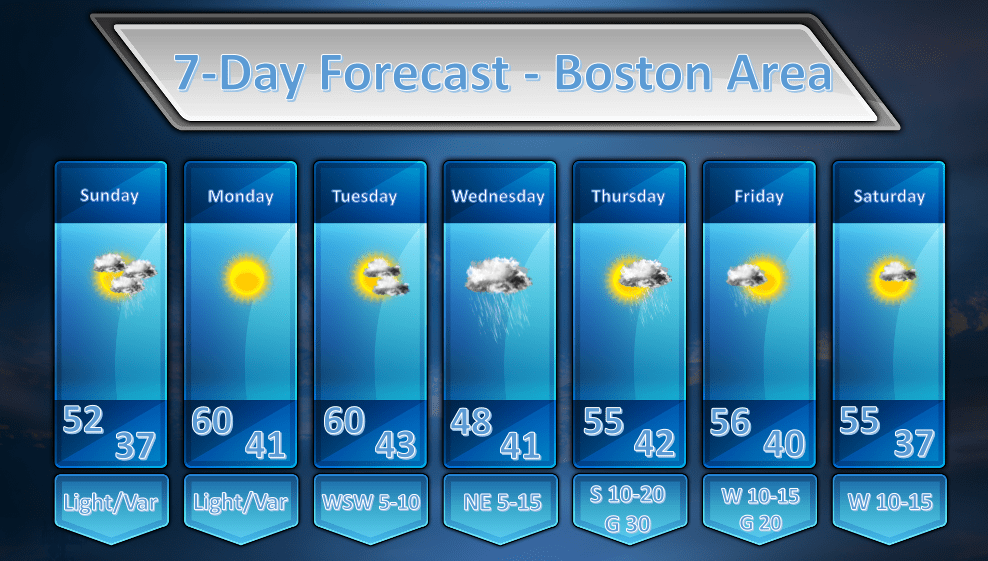
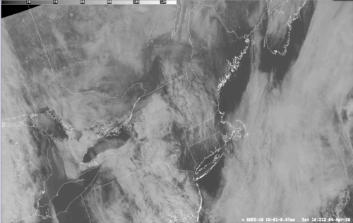
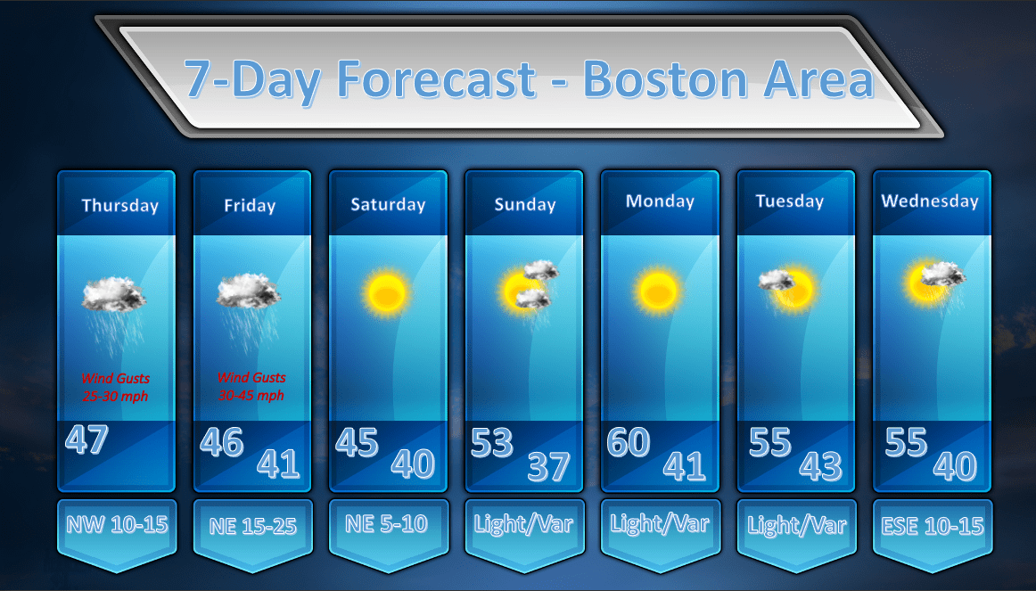
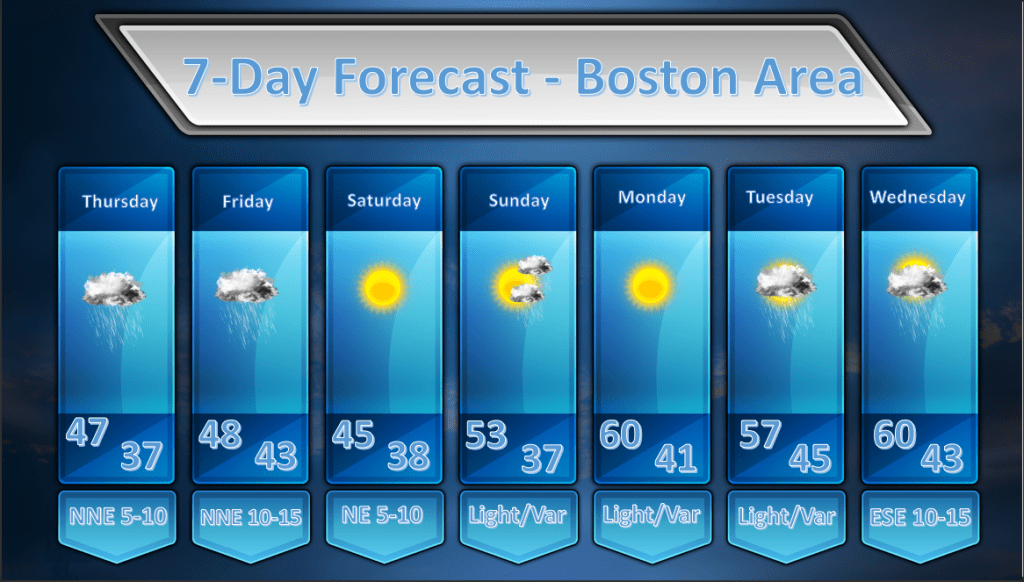
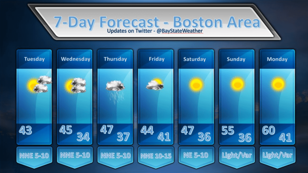
THE REST OF TODAY: Not much to say here as today was about as picture perfect a day as one could want. High temperatures around the region were largely in the upper 50’s to mid 60’s depending on exactly where you were. Winds were light for much of the day and this did allow a sea breeze to develop along the coast line and this held temperatures in Boston in the mid 50’s. The wind did flip around into the west at Logan Airport at 5pm and the temperature shot up to 61 there as well so everywhere got to bask in the beautiful early April weather. Tonight will be dry and seasonable as a weak bubble of high pressure settles in. Temperatures will settle down to around 40 in Boston and into the low to mid 30’s in the burbs.

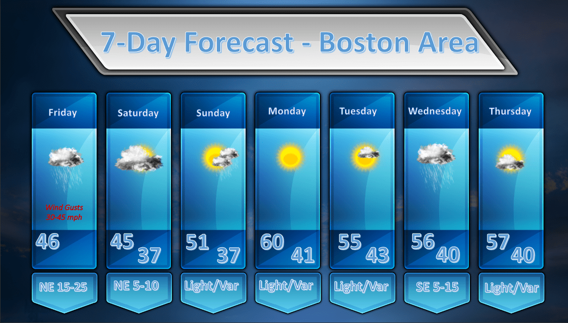
TUESDAY: Should be another winner as the overall weather pattern remains relaxed. Winds will continue to be light so, again tomorrow, a coastal sea breeze is likely to develop and that will hold temperatures at the immediate coast down into the mid 50’s while inland temperatures will be 60-65. Some spots south of the MA Pike might even try to make a run at the 70 degree mark.

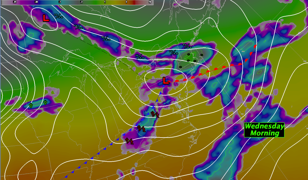
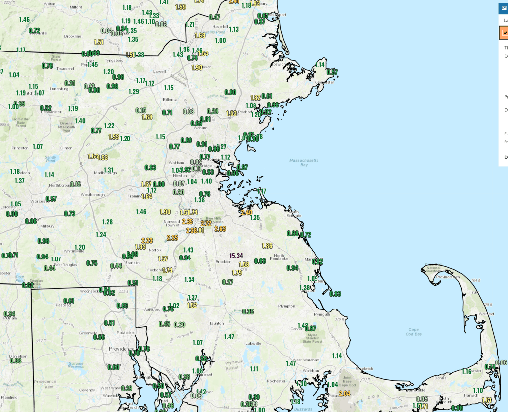
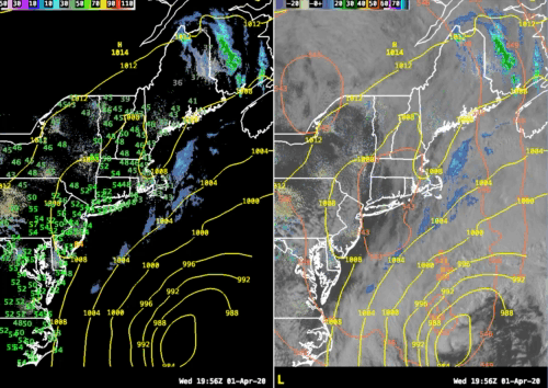
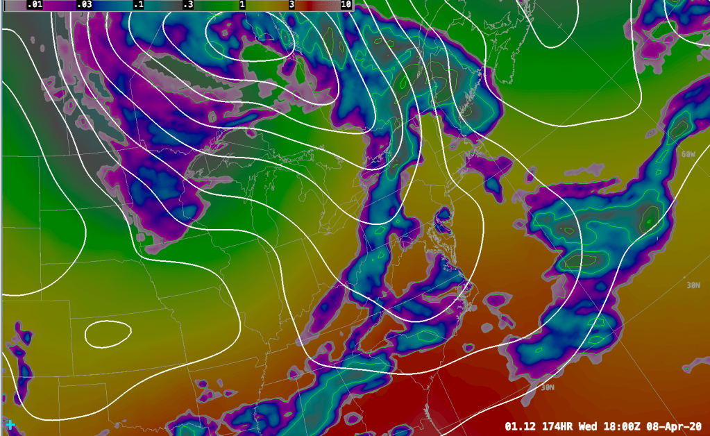
WEDNESDAY: A weak upper level impulse will ride along the flow on Wednesday and start to throw precipitation our way by sunrise. It looks like we could see .15 – .30″ of rain from this system. Wednesday just looks like a cloudy, cool and dreary day with periods of light rain. No big storm, just wet. The rain should start to taper off by mid to late afternoon and the remainder of Wednesday should just be cloudy and damp but the rain should end before sundown. Wednesday night a bubble of high pressure will crest on top of us and this should dry out the clouds and the night time hours of Wed into Thurs should be pleasant.

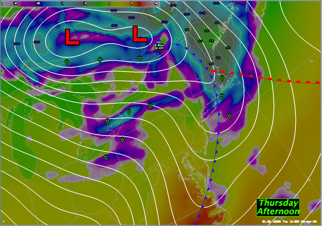
THURSDAY: Thursday will start off sunny but a very vigorous cold front will approach quickly from the west and bring some showers into New England by the late morning/early afternoon hours. It will be very breezy too with southerly winds 10-20 mph gusting upwards of 35 mph, especially late in the day, in the immediate Boston area. Out over SE mass, the Cape and Islands sustained winds will be in the 20-30 mph range and wind gusts could get up around 40-45 mph before the cold front rips through the area during the late evening hours.

FRIDAY: A large upper low will settle over the northeast on Friday and this will allow for variably cloudy skies and in and out sunshine. As spokes of energy rotate around the upper low I can’t rule out the chance of a shower.

SATURDAY: The upper low lifts a bit to the north but we will still see spokes of energy whipping around so I still envision an unsettled day with the risk of a shower.

SUNDAY: The upper low lifts away completely by Sunday and it looks like a mostly sunny and mild day. The models are suggesting that some high clouds may slide in during the day but, if this verifies, it should be the pick of next weekend.

Boston Area Forecast – April 5 2020

Issued April 5 2020 – 11:30 am

The weather forecast continues to look fairly tame for the next several days as the atmosphere settles down after a fairly active period.

The dominant feature on this morning’s weather map is a cold front the extends down from a low pressure area just east of James Bay. This front doesn’t pack much of a punch and there are just a few showers here and there along it. This front will pass through our area during the evening hours tonight with little fanfare. The most we might see as it passes through is a stray shower here and there. It will remain mostly cloudy today, unfortunately as low level moisture, being focused by a weak trough of low pressure at the surface, will hang in.

By Monday winds will flip into a drier NW direction and that should clear us out. Once the sun is really able to work on the atmosphere we should start to see some spring time temperatures around here (finally!).

High temperatures both Monday and Tuesday look like they will make it into the upper 50’s and some places will push up into the lower 60’s. It should be a pair of beautiful days.

By Wednesday another low pressure system will be on the approach and this will bring us another round of rainfall. Don’t worry, this will not be the epic kind of rainfall that we saw on Friday. This storm will be weaker and will also keep moving along rather briskly. .25-.60″ of rainfall will probably do it generally for this storm. Heaviest rainfall will be focused over eastern MA.

The next weather event will arrive quickly in the form of a cold front that will push into our area Thursday afternoon. The exact timing of the frontal passage isn’t 100% clear yet but I would favor slightly later in the afternoon over earlier but that will become clearer as the models lock on to this feature a little better. Either way it looks like we will see some showery weather for Thursday as this front moves through but it shouldn’t be a wash out by any means. .15-.25″ of rainfall in showers will be possible.

The front will slide off shore by Friday and the remainder of the week looks pleasant with partly sunny skies for the most part. My confidence in the temperature forecast out that far isn’t high due to the fact that the models are forecasting a fairly strong closed upper low over the northeast US by Friday/Saturday. My thinking is that the GFS MOS guidance is a bit too warm in that time range but I find it hard to argue with the guidance that far out. So, I’m going with it for now but as time goes on I have a feeling we will be lowering the max temps for next weekend by a little bit.

Boston Area Forecast – April 4 2020

Issued April 4 2020 – 3:30 pm

What a difference a day makes!

The rain and high winds that were spread all throughout Southern New England yesterday have been replaced by partly sunny skies and slightly warmer than expected temperatures.

The moisture that was expected to hang on in the lower levels of the atmosphere today dried out much faster than expected and we’ve been left with partly to mostly sunny skies across much of the region.

If you watch the satellite loop above which starts around 6am this morning and finishes around 2pm you can see the cloud layer that covered much of Southern New England burn away as the ocean storm pulls away to the SE. While this was not entirely expected, I doubt anyone is complaining about the extra sunshine we’re seeing today. :-). Closing out this look at the past, I felt like I would be remiss if I didn’t talk about how much rain we got in yesterday’s storm:

Eastern Massachusetts took the brunt of the rainfall from this system yesterday with over an inch of rain received in many areas. The jackpot for rainfall amounts was right near the Blue HIlls where 1.5 – 2.8″ of rainfall came down across a fairly small area near Milton, Norfolk, Foxborough and Norwood.

So, now that the big storm is by us, what’s next?

The two maps above show how the upper level pattern will be shaping up over the next 2-4 days. Starting on the left, looking at early next week, we will have a ridge of high pressure building through the mid section of the country which will lead to above normal upper atmospheric heights. This directly translates into warmer temperatures moving into the midwest and trying to poke into the Northeastern US. This should lead to rather pleasant conditions for us Sunday – Tuesday. On Sunday a weak cold front will slide across New England and may generate a shower or two late in the day.

The weather pattern is rather progressive in the mid latitudes meaning that systems are moving west to east at a fairly normal pace for this time of year. The blocking that was once present over the North Atlantic has retrograded back to Baffin Island in Canada. This is generally blocking any real serious shot of cold air from coming into the CONUS in the next 5-7 days.

By the mid – late part of this upcoming week the ridge will slide toward the east and a wave of low pressure will move to our south on Wednesday. This will likely throw a shield of rain on top of us Wednesday morning through the early evening.

A large upper low will move over the Great Lakes by Thursday morning. This is going to bring much colder weather into that area and will favor the formation of a storm system in southern Canada and this in turn is going to drag a cold front across our area by Thursday evening. This front may generate some precipitation for us here in New England in the later part of the day on Thursday. The details are still a little foggy with the Euro model showing the most precipitation over our area late Thursday. The GFS by contrast is much less aggressive with this system.

By Friday the upper air pattern has a very cold look for the northeast but, again, the details are in flux. The Euro model has a large upper low parked over eastern Canada and the northeast US. This should bring much below normal temperatures to the Northeast but it should be dry. The GFS holds back this feature to the west a bit which would favor a slightly warmer forecast but also a slightly wetter one.

The details of the longer range forecast will sort themselves out in the next couple of days.

Boston Area Forecast – April 3 2020

Issued April 3 2020 – 1:30 pm

Rain and wind dominate today’s forecast as the ocean storm we’ve been tracking for the last couple of days rages on out over the ocean. The storm is making its closest pass to New England as of this writing so we are experiencing the maximum impacts from this system.

The heaviest of the rain from this system came through last night but the wind is still very much a factor along the coast. Reported wind gusts from this storm:

LOCATION             MAX WIND     TIME/DATE   COMMENTS
                        GUST            OF
                         MPH    MEASUREMENT

CONNECTICUT

...Windham County...
   Willimantic AP          31  1213 PM  4/03  ASOS

MASSACHUSETTS

...Barnstable County...
   Chapin                  56  1137 AM  4/03  Mesonet
   Wellfleet               56  1131 AM  4/03  Mesonet
   East Falmouth           55  1206 PM  4/03  NONE
   Provincetown AP         51  1145 AM  4/03  AWOS
   Hyannis AP              49  1236 PM  4/03  ASOS
   Chatham AP              48  1243 PM  4/03  ASOS
   Yarmouth                45  1124 AM  4/03  CWOP
   Otis AFB                44  1245 PM  4/03  AWOS
   Orleans                 44   900 AM  4/03  CWOP
   West Chatham            42   125 PM  4/03  CWOP
   East Harwich            40   103 PM  4/03  CWOP
   Yarmouth Port           40   111 PM  4/03  CWOP
   Bourne                  39  1000 AM  4/03  CWOP
   West Harwich            37   132 PM  4/03  CWOP
   Hyannis                 32  1240 PM  4/03  CWOP

...Bristol County...
   New Bedford AP          44  1228 PM  4/03  ASOS
   West Island             40  1031 AM  4/03  CWOP
   Norton                  37  1210 PM  4/03  CWOP
   Taunton                 36   136 PM  4/03  CWOP
   Dartmouth               36  1221 PM  4/03  CWOP
   Fairhaven               35  1207 PM  4/03  CWOP
   Taunton AP              35  1135 AM  4/03  ASOS
   Somerset                32  1130 AM  4/03  CWOP
   Fall River              31  1235 PM  4/03  CWOP

...Dukes County...
   Aquinnah                51   809 AM  4/03  Ham Radio
   Edgartown               49  1009 AM  4/03  Ham Radio
   Marthas Vineyard AP     46  1217 PM  4/03  ASOS

...Essex County...
   Beverly AP              45  1124 AM  4/03  ASOS
   Lawrence AP             43   111 PM  4/03  ASOS
   Gloucester              41   120 PM  4/03  CWOP
   Newburyport             39  1215 PM  4/03  CWOP
   Rockport                38  1000 AM  4/03  CWOP
   Lynn                    37  1025 AM  4/03  CWOP
   Lawrence                35   136 PM  4/03  CWOP
   Bradford                34  1225 PM  4/03  CWOP
   Beverly                 31  1245 PM  4/03  CWOP

...Middlesex County...
   Medford                 48  1218 PM  4/03  CWOP
   Bedford AP              41  1233 PM  4/03  ASOS
   Weston                  35  1143 AM  4/03  CWOP
   Watertown               34   117 PM  4/03  CWOP
   Cambridge               33  1155 AM  4/03  CWOP
   Woburn                  32  1146 AM  4/03  CWOP
   Waltham                 32  1233 PM  4/03  CWOP
   Melrose                 31  1250 PM  4/03  CWOP

...Nantucket County...
   Siasconset              57   115 PM  4/03  CWOP
   Nantucket AP            56  1213 PM  4/03  ASOS

...Norfolk County...
   Blue Hill ASOS          49  1140 AM  4/03  ASOS
   Milton                  47  1155 AM  4/03  CWOP
   Wrentham                39   118 PM  4/03  CWOP
   Norwood AP              38  1213 PM  4/03  ASOS
   Dedham                  37  1111 AM  4/03  CWOP
   Bellingham              31   102 PM  4/03  CWOP

...Plymouth County...
   Duxbury                 48  1000 AM  4/03  Ham Radio
   Plymouth AP             46  1031 AM  4/03  ASOS
   Marshfield AP           41  1135 AM  4/03  AWOS
   Plymouth                38   109 PM  4/03  CWOP
   Scituate                38  1146 AM  4/03  CWOP
   Hanover                 37  1005 AM  4/03  CWOP
   Wareham                 36   930 AM  4/03  CWOP
   Mattapoisett            31  1015 AM  4/03  CWOP

...Suffolk County...
   Logan AP                49  1251 PM  4/03  ASOS
   Winthrop                39   121 PM  4/03  CWOP
   Boston                  35  1231 PM  4/03  CWOP

...Worcester County...
   Worcester AP            32   858 AM  4/03  ASOS

RHODE ISLAND

...Bristol County...
   Bristol                 31   115 PM  4/03  CWOP

...Kent County...
   TF Green AP             44  1226 PM  4/03  ASOS

...Newport County...
   Newport AP              40  1043 AM  4/03  ASOS
   Middletown              38   958 AM  4/03  CWOP
   Little Compton          32  1002 AM  4/03  CWOP

...Providence County...
   Smithfield-Lincoln A    37  1158 AM  4/03  AWOS
   1 SE Providence         32  1206 PM  4/03  HADS

...Washington County...
   4 SW South Kingstown    46   125 PM  4/03  HADS
   Quonset AP              43  1250 PM  4/03  AWOS
   Block Island AP         40   116 PM  4/03  AWOS
   Westerly AP             39  1253 PM  4/03  ASOS
   Narragansett            37  1101 AM  4/03  CWOP
   Charlestown             35  1115 AM  4/03  CWOP


***********************SUSTAINED WIND***********************

LOCATION                 WIND     TIME/DATE   COMMENTS
                        SPEED           OF
                         MPH    MEASUREMENT

MASSACHUSETTS

...Barnstable County...
   East Falmouth           36  1206 PM  4/03  NONE

These data are provided by the National Weather Service office in Norton, MA.

As you can see, across much of the eastern portion of our area it’s been a pretty wild day with wind gusts in excess of 50 mph out over Cape Cod and gusts of 35-50 mph reported around the Boston area.

The good news is that this storm is now on its way out of the region as it completes the loop back toward the west that took place through Thursday night. Clouds and showers will remain a fixture in our weather through the rest of today but conditions should gradually improve with diminishing winds as we head into Saturday.

Speaking of Saturday, it looks like Saturday will be a less nice day than I’ve been thinking as the low level moisture, enhanced by NE winds feeding in Atlantic moisture, hangs tough. It will be less windy and it should also be fairly dry albeit cool and cloudy. Improving weather will move in by Sunday with the slight risk of a shower late in the day on Sunday and then Monday and Tuesday look like great days with temperatures above normal, light wind and sunshine.

It looks like a weak impulse will track south of our area on Wednesday and that will probably throw some rainfall back our way then. Next Thursday, at least for now, looks pretty good.

Stay healthy and safe out there!

Boston Area Forecast – April 2 2020

Issued April 2 2020 – 10:30am

Good morning!

This is primarily an update to yesterday’s forecast so I am going to keep the discussion brief. The forecast is working out more or less as expected.

The storm that slid by to the south yesterday blew up into a monster out at sea overnight.

If you look carefully at the storm you can make out an eye like feature at its center. This is normally seen with hurricanes but it can also manifest in fairly intense mid-latitude cyclones. Observations indicate that this system has a central pressure below 980 mb. By comparison, Superstorm Sandy had a central pressure of 945.5 mb over Atlantic City when it made landfall back in 2012. So while this storm is a bit weaker it still packs quite a punch.

This system will impact New England but not in the same way that Sandy tore into the Mid-Atlantic coast 8 years ago. This storm will generate some pretty rough weather conditions along the coast tonight and on Friday. The low pressure area is currently performing a loop and is, at this moment, moving in a westerly direction. This is called retrograde motion. The storm will continue to retrograde back toward the New England coast through Friday morning. As it does so it will wrap some fairly hefty rainfall and wind back toward New England.

The image above is the wind speed and direction and wind gust speed forecast from the 12km North American Model (NAM-12). This forecast is for 11am Friday. As you can see, sustained winds (on the left) in Boston are going to be from the NE at 15-25 kt (1 kt = 1.15 mph in case you want to convert). Out on Cape Cod, however, you will be contending with 20-35 kt sustained winds out of the NE. What’s worse are the wind gusts. In the Boston area we are looking at 35-40 kt gusts and out on the Cape and Islands 40-50 kt gusts are not out of the question. One way or the other, if you are planning to venture out tomorrow for any reason, it’s not going to be pleasant, especially in the morning hours when the storm is making its closest pass.

In addition to the wind, we are also going to get quite a bit of rainfall during the next 48 hours or so. The images above show the 12 hour rainfall amounts from the 40km NAM (NAM-40). The image on the left runs from 8pm tonight through 8am tomorrow morning and the image to the right shows total precipitation from 8am Friday – 8:00pm Friday. The totals over Boston add up to about 1.20″ of rainfall from 8pm tonight through 8pm Friday night. The GFS model shows about 1.30″ for the same time period so, all in all, we are looking at a pretty good soaking from this system on top of the wind. Great day to say socially distanced and indoors.

As for the remainder of the forecast:

Once the storm gets out of here on Saturday the sun should return and it looks like we will see a gradual warming trend into next week. Sunday may feature a shower or two as a weak front slides by but I’m not totally sure we’ll even see rain at all from that system. Tuesday may bring along a morning shower and we may see late day showers on Wednesday, but again, these are iffy chances of precipitation at this point.

That’s all for today!

Boston Area Forecast – April 1 2020

Wednesday’s weather panned out pretty much as advertised as the day started sunny and then clouds have begun to slide in. Most of the cloudiness right now is of the mid and high variety but, looking at the satellite loop, lower clouds containing rain are advancing in from the east. From the east? Yup!

A storm system is currently spinning away to our south and has turned our winds locally into the NE. This has thrown quite a bit of moisture back at us and that process is only just starting. As the night progresses we will see this system start to really wind up and it will begin to perform a loop out at sea. As the storm loops through the day tomorrow it will throw clouds and rain back toward New England. The loop from the NAM12 model (shown below) demonstrates this process happening, at least in the mind of the model, pretty clearly.

The other computer models GFS, European and Canadian models all support this idea of the low looping around. The overall pattern also supports this due to high latitude blocking around Greenland that continues to be the major weather feature on the global weather models. This feature is jamming up the upper level weather pattern and in turn storms near the surface also get caught in this atmospheric log jam.

Fortunately this block is in the process of breaking down and soon the normal west to east progression of weather events will resume. The forecast reflects that with some rainfall on Thursday and Friday. The sun should return by Saturday as the storm finally shoves off and an upper level ridge of high pressure builds over the eastern US. On Sunday a weak frontal boundary will transit across the area and this may lead to a fairly cloudy day with the risk of a shower or two.

By Monday the sun should come back out and a fairly light WSW wind should develop. This will allow temperatures to rocket up into the low 60’s. I’m being conservative with the temperature forecast on Monday but, if we stay relatively clear, temperatures could even go into the mid 60’s or better.

Tuesday looks like a cloudy and mild day with the risk of a shower or two as a warm front tries hard to push northward into New England but I don’t think it’s going to get very far. Wednesday will be another mild and kind of cloudy day as we watch a cold front approaching from the west.

Boston Area Forecast – March 31 2020

Today started off much nicer than I thought it would! This morning we had abundant sunshine as the sun came up over the horizon. A weak inverted ridge of high pressure built over New England this morning and that allowed the low overcast to dry out.

Unfortunately the bright sunshine isn’t going to be a permanent fixture today as the atmosphere remains unstable thanks to a pool of cold air sitting over us. As the sun comes up the atmosphere will destabilize and clouds will form. Still, we should have a mix of sun and clouds which is better weather than we’ve had. It’s also possible that a shower or two will develop but I’ve left that out of the forecast this morning hoping that the relatively dry air mass will suppress any shower development.

Looking at Wednesday, that should be a dry and partly cloudy day for the most part. A storm system will be sliding south of us through the day on Wednesday but, initially, this storm will be too far to the south to throw any rainfall our way. By Wednesday evening, however, this storm will stall out over the ocean and then perform a loop around. While this loop is happening it looks like we’re going to have some rainfall thrown our way. It appears Thursday will be fairly gloomy once again with rain, drizzle and fog as the ocean storm continues to throw moisture back at us from the east.

This storm will shove off by Friday and, going into the weekend it looks like our weather will get better and better each day. By next Monday I’m looking at the possibility of 60 or better! That should make everyone feel a little more optimistic.