Very active and stormy weather pattern ahead! Read all the details in today’s forecast post!
Category Archives: Massachusetts Weather
Southern New England Forecast
Very active and stormy weather pattern ahead! Read all the details in today’s forecast post!
Southern New England Forecast
Issued: April 22, 2020 at 3:30 pm WEATHER SUMMARY: *** FOR THOSE OF YOU THAT FOLLOW THIS BLOG, MY APOLOGIES FOR THE LACK OF POSTS THE LAST FEW DAYS. I HAVE BEEN WORKING ON A PROJECT THAT WILL ACTUALLY HELP ME DELIVER THIS TO YOU AND IT TOOK QUITE A BIT OF TIME AND EFFORT.Continue reading “Southern New England Forecast”
Spotter Reports from April 17/18 Event
NOUS41 KBOX 182009 PNSBOX CTZ002>004-MAZ002>024-026-RIZ001>008-190809- Public Information Statement Spotter Reports National Weather Service Boston/Norton MA 409 PM EDT Sat Apr 18 2020 The following are unofficial observations taken during the past 20 hours for the storm that has been affecting our region. Appreciation is extended to highway departments, cooperative observers, Skywarn spotters and media forContinue reading “Spotter Reports from April 17/18 Event”
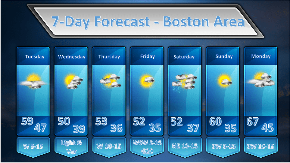
Boston Area Forecast – April 17, 2020
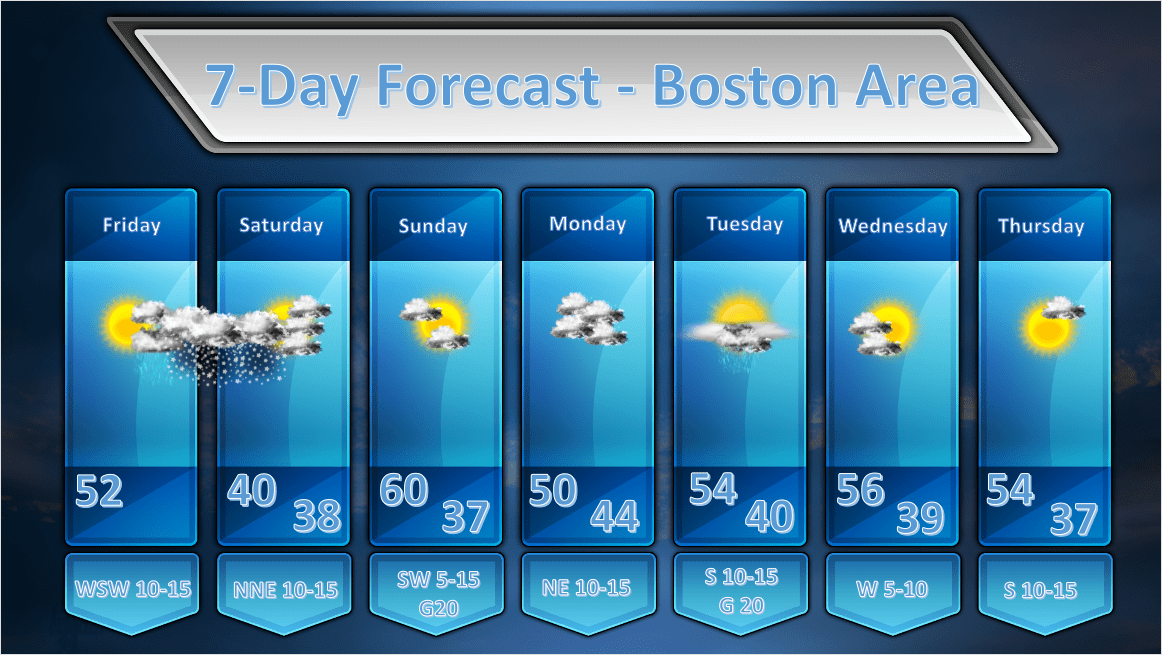
Issued: April 17, 2020 at 12:30 pm ***A LIGHT TO MODERATE SNOWFALL EVENT IS LIKELY TONIGHT INTO SATURDAY*** FORECAST DISCUSSION: THIS AFTERNOON: A weak ridge of high pressure at the surface and aloft will allow us to have a very nice afternoon today. High temperatures will be a little on the cool side for thisContinue reading “Boston Area Forecast – April 17, 2020”
Boston Area Forecast – April 16, 2020
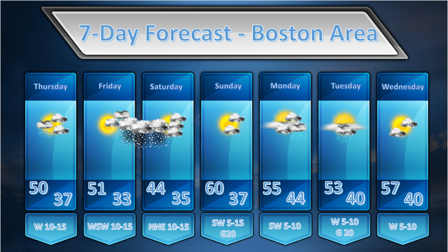
Issued: April 16, 2020 at 1:00am FORECAST DISCUSSION: TODAY: During the early morning hours an upper level disturbance will be transiting across the area and this may generate a shower or two in the morning. This still looks like a fast mover and most of the rainfall should be over before or right around sunrise.Continue reading “Boston Area Forecast – April 16, 2020”
Boston Area Forecast – April 15, 2020
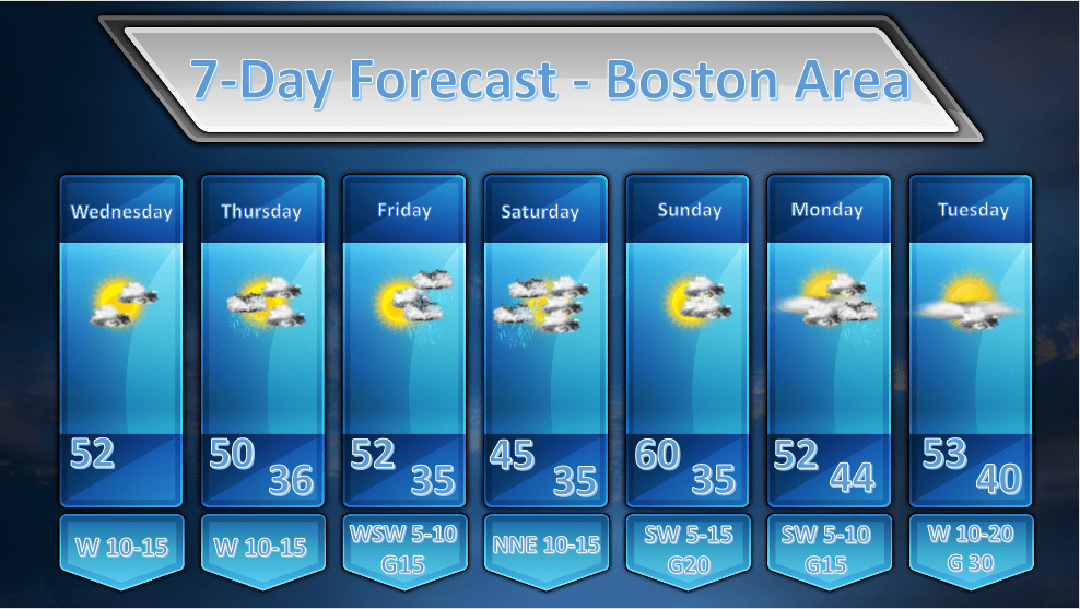
Issued: April 15, 2020 at 11:00am FORECAST DISCUSSION: WEDNESDAY: A weak wave of low pressure is sliding south of New England this morning. Along with this low are variable amounts of cloudiness from the South Shore northwestward, and overcast skies to the southeast with some light rain out over Cape Cod. As all of thisContinue reading “Boston Area Forecast – April 15, 2020”
Storm Reports from April 13 Event
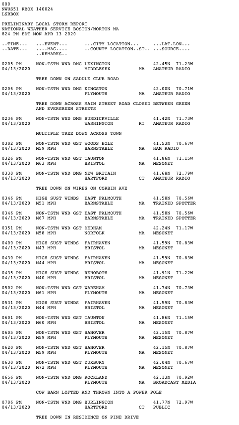
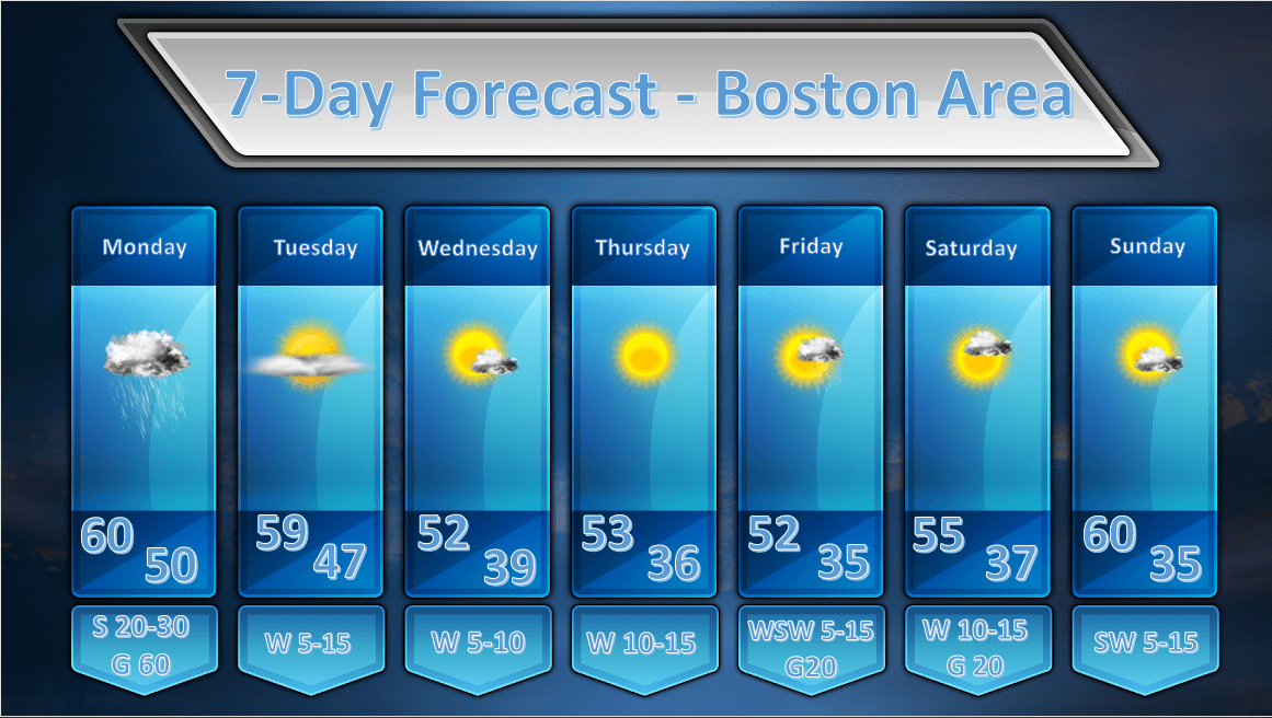
Boston Area Forecast – April 13, 2020
Issued: April 13, 2020 at 9:00pm FORECAST DISCUSSION: TUESDAY: We should start of mostly sunny on Tuesday as a surface high pressure ridge builds in from the west. Some mid/high level moisture will transit across New England and may generate some wispy high clouds or some middle level clouds. I am not generally expecting overcastContinue reading “Boston Area Forecast – April 13, 2020”
High Wind Warning Update – April 13, 2020
Issued: April 13, 2020 at 12:30 pm We are starting to see increasing sustained winds and wind gusts across all of southern New England as today’s weather event approaches. The chart above shows all stations reporting wind gusts of 20 mph or more. Generally wind gusts of 25-35 mph are found across much of MassachusettsContinue reading “High Wind Warning Update – April 13, 2020”
