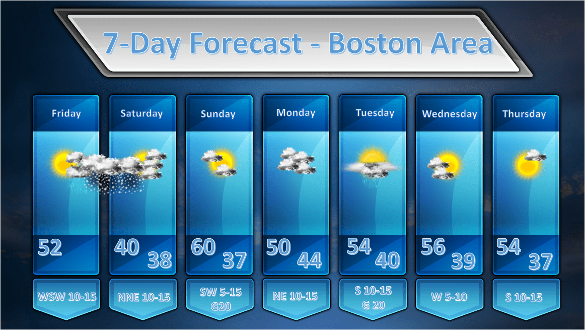
Issued: April 17, 2020 at 12:30 pm ***A LIGHT TO MODERATE SNOWFALL EVENT IS LIKELY TONIGHT INTO SATURDAY*** FORECAST DISCUSSION: THIS AFTERNOON: A weak ridge of high pressure at the surface and aloft will allow us to have a very nice afternoon today. High temperatures will be a little on the cool side for thisContinue reading “Boston Area Forecast – April 17, 2020”
Tag Archives: Meteorology
Boston Area Forecast – April 16, 2020
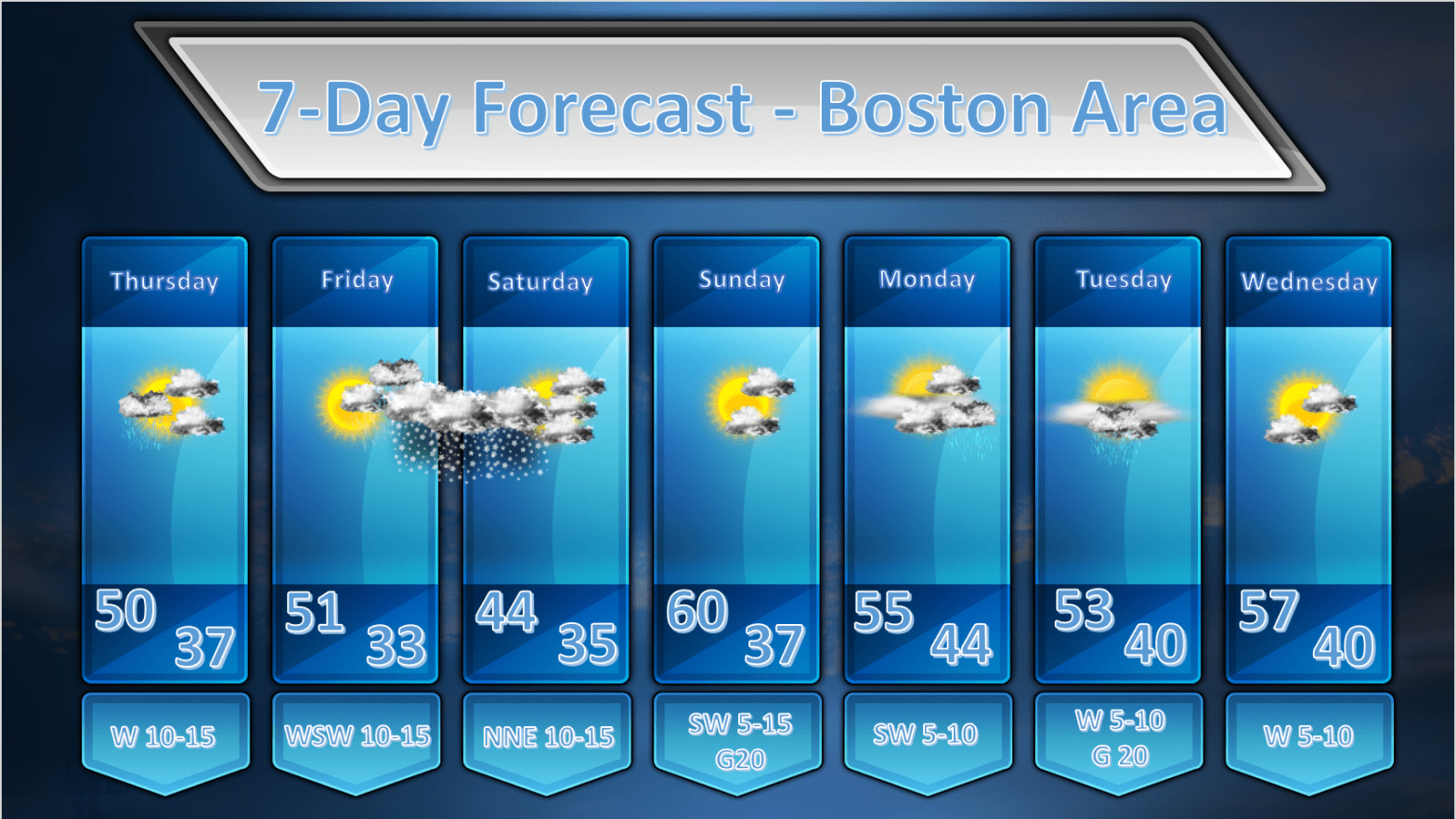
Issued: April 16, 2020 at 1:00am FORECAST DISCUSSION: TODAY: During the early morning hours an upper level disturbance will be transiting across the area and this may generate a shower or two in the morning. This still looks like a fast mover and most of the rainfall should be over before or right around sunrise.Continue reading “Boston Area Forecast – April 16, 2020”
Boston Area Forecast – April 15, 2020
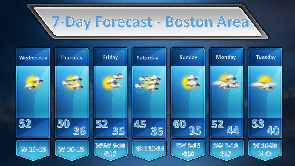
Issued: April 15, 2020 at 11:00am FORECAST DISCUSSION: WEDNESDAY: A weak wave of low pressure is sliding south of New England this morning. Along with this low are variable amounts of cloudiness from the South Shore northwestward, and overcast skies to the southeast with some light rain out over Cape Cod. As all of thisContinue reading “Boston Area Forecast – April 15, 2020”
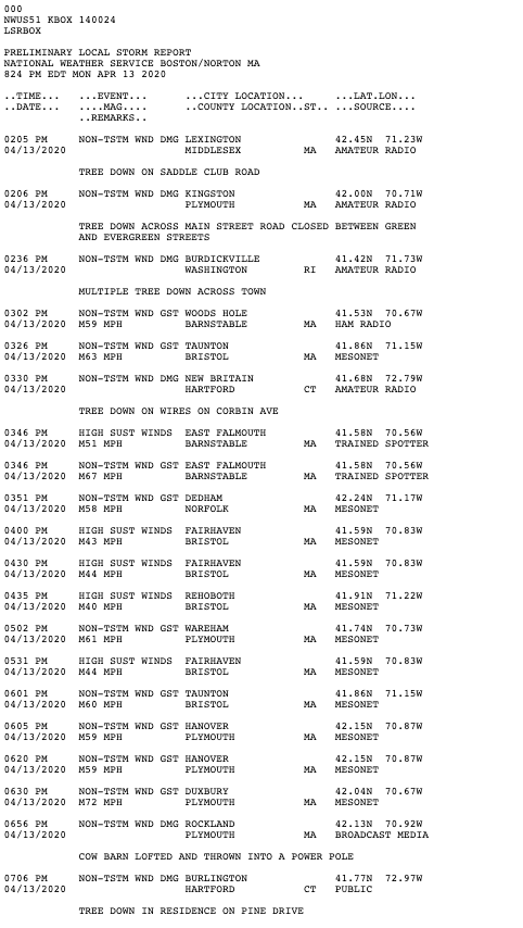
Storm Reports from April 13 Event
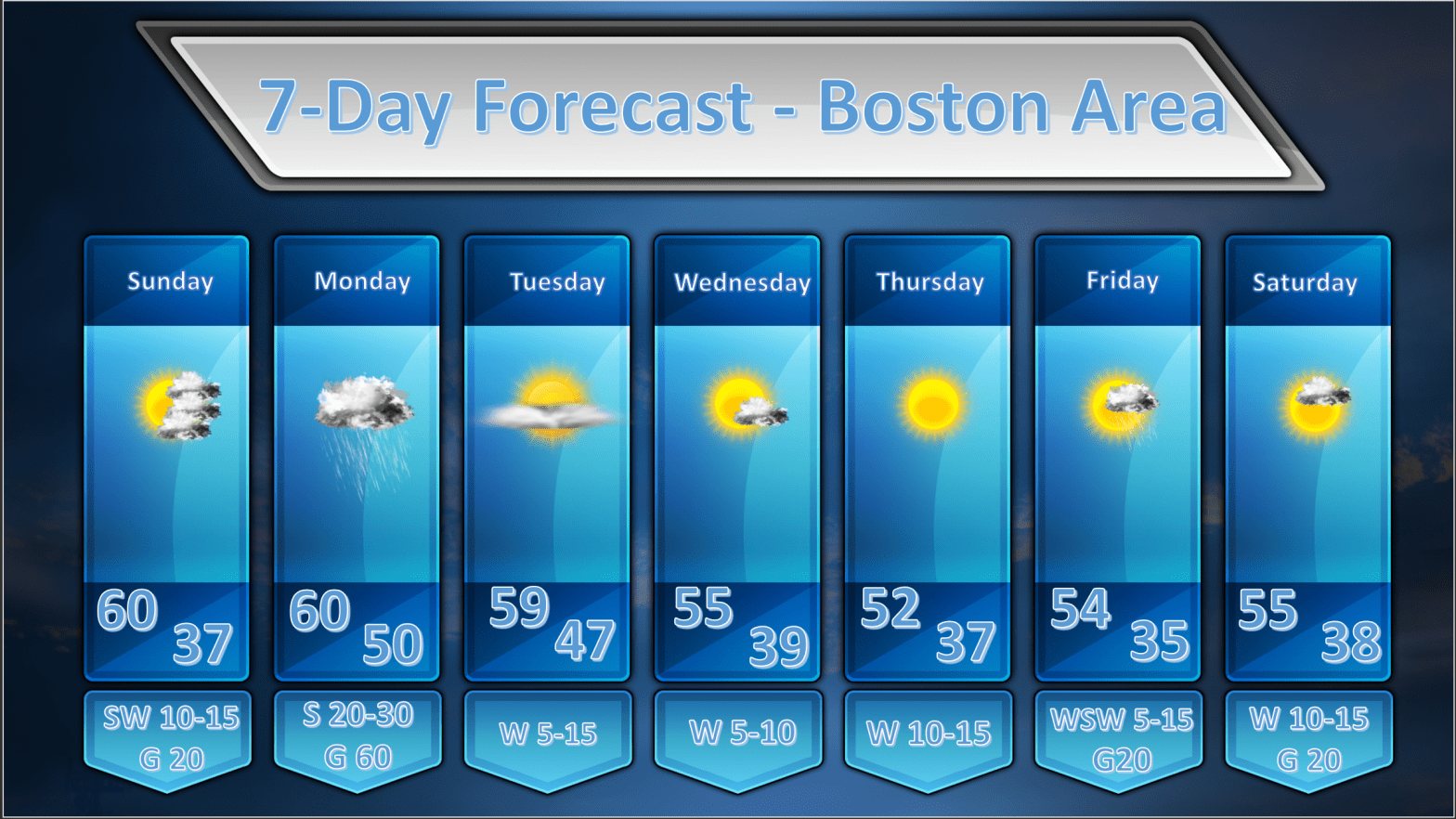
Boston Area Forecast – April 13, 2020
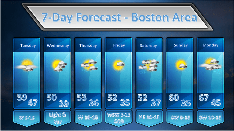
Issued: April 13, 2020 at 9:00pm FORECAST DISCUSSION: TUESDAY: We should start of mostly sunny on Tuesday as a surface high pressure ridge builds in from the west. Some mid/high level moisture will transit across New England and may generate some wispy high clouds or some middle level clouds. I am not generally expecting overcastContinue reading “Boston Area Forecast – April 13, 2020”
High Wind Warning Update – April 13, 2020
Issued: April 13, 2020 at 12:30 pm We are starting to see increasing sustained winds and wind gusts across all of southern New England as today’s weather event approaches. The chart above shows all stations reporting wind gusts of 20 mph or more. Generally wind gusts of 25-35 mph are found across much of MassachusettsContinue reading “High Wind Warning Update – April 13, 2020”
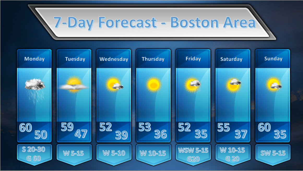
Boston Area Forecast – April 12, 2020
Issued: April 12, 2020 at 9:00pm The focus of tonight’s discussion will be on the weather event that will move into New England by tomorrow morning. The major highlights of tomorrow’s weather will be: Strong and gusty winds with possible wind gusts in excess of 50 mph in metro Boston and upwards of 70 mphContinue reading “Boston Area Forecast – April 12, 2020”
Special Weather Outlook – April 12, 2020
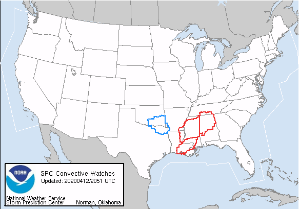
Severe Weather Outbreak Potential for Southern United States Issued: April 12, 2020 @ 5:00pm The national weather service issued Tornado Watch 109 at 420pm EDT for much of central and northern Alabama as the severe weather outbreak continues this afternoon across the southern US. While official tornado reports have been relatively sparse at this timeContinue reading “Special Weather Outlook – April 12, 2020”
Special Weather Outlook – April 12, 2020
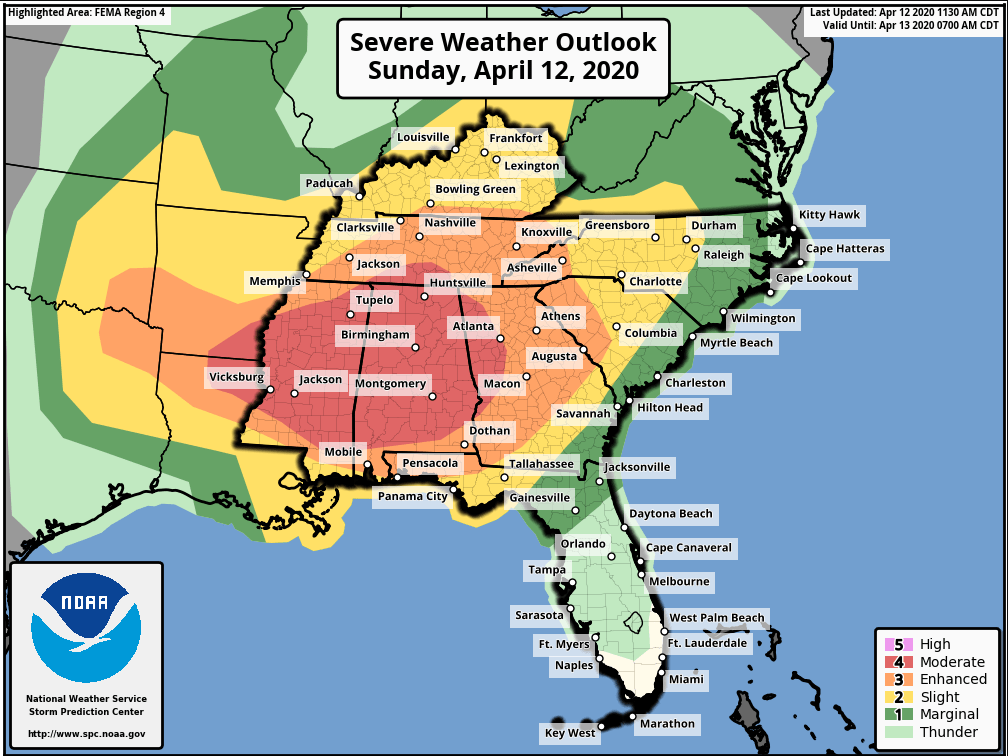
Severe Weather Outbreak Potential for Southern United States Issued April 12 2020 – 1:00 PM FORECAST DISCUSSION: There continues to be a very real possibility of a serious severe weather outbreak across the southern United States this afternoon. Presently there is a complex of severe thunderstorms moving through north central Louisiana and tornadoes have beenContinue reading “Special Weather Outlook – April 12, 2020”
Boston Area Forecast – April 11, 2020
Issued: April 11, 2020 at 7:20pm This will be a short discussion this evening as there really aren’t any major changes to the forecast. There are, however, some fairly important notes for Monday. The map below is a map of the watches and warnings issued for Southern New England. The brown outlines which are shownContinue reading “Boston Area Forecast – April 11, 2020”
